geotimesheader
News
Notes
Technology
Government
ends GPS scrambling
Doug Walker received an e-mail message May 1 telling
him that Selective Availability, the U.S. militarys degradation of the
signals coming from Global Positioning System (GPS) satellites, had been
shut off. The next day, Walker, who teaches geologic mapping at the University
of Kansas, joined two colleagues and took his $200, hand-held GPS receiver
outside. It read his position to within about 20 feet it used to read
it to within 100 feet.
| Its going to make a huge difference,
says Walker, who has been developing methods for using GPS and other technologies
that will allow geologists to create digital maps from the field. Im
virtually positive now that GPS accuracy is going to be on the order you
see on topo maps.
The U.S. Department of Defense developed and launched
the GPS satellites in the 1970s as a military tool for determining positions
on Earths surface. Fearing potential U.S. enemies could use the system
to target missiles, the military degraded the signals so that a single
GPS receiver could only measure a given position to within 100 meters.
With Selective Availability shut off, a receiver could potentially measure
a position to within 10 meters. |
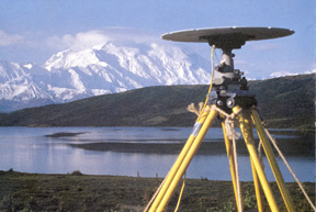
Geoscientists
use GPS receivers to monitor
deformation
of Earth's surface. Here, a receiver sits
near
Alaska's Mount McKinley. |
The time it takes radio signals to travel
from four of the 25 GPS satellites to a ground-based GPS receiver helps
determine that receivers 3-D position. Thus the GPS satellites are ideal
tools for measuring position and for navigating around the globe. According
to a White House statement released May 1, the $8-billion market for commercial
GPS applications should double in the next three years. The decision to
discontinue Selective Availability [SA] is the latest measure in an ongoing
effort to make GPS more responsive to civil and commercial users worldwide,
the statement read.
Earth scientists are increasingly using GPS for
a range of data collection, from measuring displacement of Earths crust
over time to quantifying water vapor by the speed at which the signals
travel through the atmosphere.
The United States will stop the intentional
degradation of the Global Positioning System signals available to the public
beginning at midnight tonight, the White House announced in the same statement
May 1. The decision to discontinue SA
is supported by threat assessments
which conclude that setting SA to zero at this time would have minimal
impact on national security. The military will still jam GPS signals regionally
if national security is threatened, it added.
Geoffrey Blewitt, a University of Nevada researcher
who uses GPS for tectonic studies, also received an e-mail message May
1 with the news. He says the change is exciting for mapping, but doesnt
offer such a paradigm shift for using GPS to measure deformation of Earths
surface.
Geoscientists have worked around the degradation
by differencing the signals with two receivers, measuring positions to
within millimeters of accuracy. Such precision is required for measuring
displacement around faults or vertical displacement of volcanoes.
A single receiver can cost as little as $200,
while a system of two receivers with radios for communicating data can
run up to thousands of dollars. It really affects users who use single
receivers, Blewitt says. With SA shut off, he adds, the dominant error
for hand-held receivers comes from uncertainty in a signals speed as it
passes through the ionosphere.
Single-receiver users range from designers of
Geographic Information Systems to rental car companies directing lost drivers,
says Thomas Herring, a Massachusetts Institute of Technology researcher
who also uses GPS for tectonic studies. Still, he adds, the improved signal
will make GPS data more robust because researchers will be able to accurately
and directly pinpoint the locations of the GPS satellites. Now we can
actually use the satellite clock information to give us a better indication
of whether or not the data are valid. Without SA, a GPS satellite clock
can be accurate to within 10 billionths of a second.
Kristina Bartlett
