geotimesheader
News
Notes
Hazards
Engineering
Taiwan quake
is data boon
Seismologists and engineers say that data from last Septembers multiple
earthquakes in Taiwan have given them a better understanding of how buildings
are affected by ground motion. The enormous amounts of data from the eight
Chi-Chi earthquakes will lead to advances in building design, they say.
The earthquakes, which killed more than 2,400 people, occurred nearly in
the center of a high-density network of recording stations and created
the most thorough picture of what happens to the ground during a fault
rupture.
| Engineers have eight times more data to study how buildings, bridges,
freeways, dams and harbors can be designed more earthquake resistant,
says Leon Teng, a professor in the Department of Earth Sciences at the
University of Southern California (USC).
Teng and researchers from the Institute of Earth Sciences, Academia
Sinica and the Taiwan Central Weather Bureau, both in Taipei, created a
movie of the wavefield showing the acceleration, velocity and displacement
of wave motions. The movie presented at the April Seismological Society
of America meeting in San Diego, Calif. showed that the rupture evolved
differently than was previously thought. |
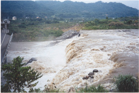
The Chi-Chi
Earthquake caused by the Chelungpu
fault
surface rupture cut through the Ta-Chia River,
forming
a fault scarp and an instant six-meter-high
waterfall.
LeonTeng, USC. |
The current theory of fault rupturing is analogous to tearing a sheet
of paper, Teng says, with the rupture velocity a measure of how fast the
tearing point travels. This tearing point was thought to be regular in
space and time, but this description may no longer be entirely accurate.
Analysis of the movie indicated that the Chi-Chi earthquakes did not follow
the accepted model.
The spots of tearing change with time and do not seem to follow any
obvious order. This is new to seismology and is important to earthquake
shaking hazard evaluation, Teng says. Seismologists will no longer be
able to calculate the rupture velocity of earthquakes because the velocity
calculation assumed that fault rupture points move regularly through time
and space.
Although not knowing the rupture velocity makes evaluating hazards from
earthquakes more difficult, advances in building designs are possible because
having so complete a data set of earthquake wave motions allows engineers
to determine the predominant wave frequencies that shake a building to
its foundation.
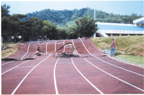
The Chelungpu
fault runs through the Kuang-Fu
School
running track, forming a three-meter scarp.
Leon
Teng, USC. |
Those are the numbers that engineers have been craving, says James
Dolan, a colleague of Tengs at USC, referring to the Chi-Chi data set.
I think that well see enormous benefits from these data, he says.
Digital strong-motion recorders over the 100-kilometer-long Chelungpu
fault surface rupture are only three to five kilometers apart, creating
a network that records wave motion from the epicenter outward. It just
happened that the earthquakes occurred in the middle of the network and
everything was recorded, Dolan says. |
The data gave seismologists and engineers a unique view of the complete
response of the ground to seismic waves, including the initiation of the
quakes and the propagation of waves. Teng says that this network and others
like it act as observation tools for understanding the physics of earthquakes.
And the more than 70,000 aftershocks that occurred generated data that
will help to clarify the geometry of the fault plane.
Some engineering changes could be immediate, Teng says, but every country
faced with potential earthquake disasters will respond differently. The
Taiwan Central Weather Bureau released the data set to the public within
a month after the earthquakes, allowing anyone to access it from the Web.
Julia Cole
Geotimes contributing writer
