geotimesheader
Where
on Earth?
| Each month, the first three readers to identify
the location pictured in the current print version of Geotimes will
receive the Glossary of Geology. The first 10 will receive
a Where on Earth?
T-shirt.
To submit photos for future Where on Earth? contests,
click here. |
Answers to
the May & April photo contests:
May
clues & answer:
Christina Reed |
Clues:
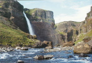
1.
Columnar joints, pictured top left, underlie large sections of this nation's
landscape.
2.
Hikers find this waterfall -- the second-tallest in the country at 120
meters -- near where "hell freezes over".
3.
Jules Verne refers to this country's western peninsula in Journey to
the Center of the Earth.
Scroll down for the answer and
winners ... |
Answer:
Haifoss waterfall is nestled west of Mount Hekla, the volcano known
as the gate to hell in mediaeval Icelandic folklore, and south of the Langjokull
glacier in Iceland. |
May winners:
Helen Delano -- York Springs, Penn.
Jesse Kasehagen -- Santa Barbara, Calif.
Honorable mention:
William Smith -- McLean, Va.
Katherine Price Blount -- Corpus Christi, Texas
Fred Hawkins -- Denver, Colo.
Nancy Williams -- Boulder, Colo.
Susan Banda -- Pamona, NJ
Mike Klein -- Boulder, Colo.
John Zeise
April
clues & answer:
David Applegate |
Clues:
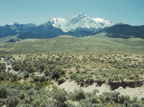
1.The
fault scarp in the foregroung was formed in the last 20 years by a magnitude-7+
earthquake that killed two people in this sparsely populated region.
2.
This 3,900-meter peak, composed of a Silurian and Devonian limestone sequence,
is the highest in a range dominated by Mississippian carbonate banks.
3.
Root vegetables are a staple of the inhabitants of the region, which was
also a favorite haunt of the author of The Snows of Kilimanjaro.
Scroll down for the answer and
winners ... |
Answer:
Borah Peak is the highest point in Idaho, a state famous for its potatoes,
and is the highest peak in the Lost River Range. It was the site of a magnitude-7.3
earthquake on Oct. 28, 1983 the largest ever recorded in Idaho. The quake
produced extensive surface faulting and landslides. It caused two deaths
and $12.5 million in damage in the Idaho towns of Challis and Mackay. |
April winners:
David Frank -- Washington, D.C.
Kate Johnson -- Reston, Va.
Roy Kepferle -- Cincinnati, Ohio
John Callahan -- Boone, N.C.
Fred Hawkins -- Denver, Colo.
Charlie Sandberg -- Lakewood, Colo.
Bill Lund -- Southern Utah University, Cedar City, Utah
Roger Smith --
Gloria Koroghlanian --
Joe Michaletz -- Helena, Mont.
Submit
your photo for a future Where on Earth?
contest
Please consider submitting your own field shots for possible
publication in "Where on Earth?" All photos will be returned. If
we run your photo in Geotimes, you'll receive a free one-year subscription
or renewal.
Mail photographs, slides or electronic files on disk to
Geotimes,
4220 King Street, Alexandria, VA 22302. Please contact
Geotimes
via e-mail at geotimes@agiweb.org
for electronic submissions and FTP instructions.
