Geotimes
Energy & Resources

Caribou study charges energy debate
Lisa M. Pinsker

Links

Gwitchin 
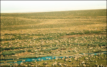
villages are strategically located to overlap with the seasonal migration routes of the Porcupine Caribou Herd, named for the herd’s crossing of the Porcupine River during its fall and spring treks between the mountains of Canada and the Arctic coast. The caribou herd has coexisted with the Gwitchin people for thousands of years, providing them food and clothing. In the summertime, the caribou calve along the Beaufort Sea coast after roaming through the Arctic National Wildlife Refuge (ANWR), where the potential for oil drilling has become the centerpiece of President Bush’s energy plan.

The 123,000-member Porcupine Caribou herd calves in the summer along the Arctic coast. Image couresy of Brad Griffith

In March, just weeks before the Senate voted down an amendment that would have opened up part of the refuge to oil drilling, the U.S. Geological Survey (USGS) released a 78-page wildlife assessment. The report says that the caribou could face substantial risk of decline under certain oil development scenarios for ANWR. A week later, at the request of the Department of the Interior, the USGS released another, two-page report that examined additional scenarios, under which the caribous’ decline would be minimal. These reports launched the USGS and the caribou into a firestorm of criticism and concerns from both opponents and advocates of drilling ANWR.

A 1998 USGS assessment of oil and gas resources in ANWR estimates that between 5.7 and 16.0 billion barrels of oil are technically recoverable in the federally owned ANWR coastal plain (the so-called 1002 area), the adjacent state-owned offshore area and the native land holdings to the east — just under two million acres of land in total. They estimated that most of the economically recoverable oil lies west of the Marsh Creek Anticline in the undeformed region closest to the areas of current oil development in Prudhoe Bay.

On Aug. 1, 2001, the U.S. House of Representatives passed its version of the energy bill with an amendment allowing a maximum surface development of 2,000 acres in ANWR for oil exploration and drilling. The failed Senate amendment also included such a provision. These 2,000 acres represent the “footprint” of oil development, says Ken Bird, a petroleum geologist with the USGS. “If oil were discovered, it is the size of the area that would be covered by gravel drilling pads and roads,” and any other infrastructure, he explains.

“Over the years since Prudhoe was discovered in 1968, the size of the pads that they build to drill these wells has been decreasing and so there are some oil fields that have been developed in the last five years that are using very small pads — on the order of 50 to 100 acres,” Bird says. With that new technology, he says, came the realistic possibility of a 2,000-acre limit, where 10 different oil fields, each 100 acres in size, could then spider-web across the development area connected by another 1,000 acres in gravel roads, pipelines and infrastructure. However, Bird emphasizes, no one knows exactly how much oil lies in ANWR, nor where the oil lies and therefore what development would look like.

That’s why Brad Griffith and his research team from the USGS Biological Resources Division used five scenarios that represented a range of potential oil development in ANWR to model how drilling might affect the survival rates of the caribou, according to Bob White, a retired nutritional ecologist from the University of Alaska-Fairbanks whose research was part of the USGS study. The study calculated survival rates based on the idea that mother caribou and their newborn calves live in areas with the greatest amount and growth of green vegetation. In general, White says, oil development displaces calves to less green areas, dropping survival rates.

The hypothetical development scenarios were independently developed in 1998 by economists Arlon Tussing and Sharman Haley for the NSF-funded Sustainability of Arctic Communities project. “The scenarios randomly project the hypothetical distributions of oil discoveries given certain political scenarios of opening to exploration and development. And the probabilities were all driven by the data in the [1998] USGS assessment,” Haley explains. However, they noted in their published work that the scenarios did not include all the final numbers for the 1998 USGS assessment. Haley says that they intended to create a general range of plausible development.

The use of the Tussing and Haley scenarios stands at the heart of the debate that erupted after the release of the initial wildlife study. Opponents of drilling ANWR heralded the study for showing how full development could destroy the species. Advocates called the study incomplete and criticized it for focusing on the worst-case scenario.

“When the main report came out there was a lot of concern outside the Department [of the Interior] and particularly inside the Department that while the model ran several scenarios, it only described in detail the worst one. And it didn’t describe or run the projections we had made as to where the oil and gas were most likely to be developed in ANWR,” says USGS director Chip Groat. But, Groat says, the USGS stood by the underlying science in the report and did not want to “tinker” with the model. They decided to plug into the caribou model two additional scenarios based on the most current USGS oil data — one with most of the oil and gas concentrated in the undeformed area and the other with that area plus the native lands. In both scenarios, the study showed that the impact of oil development on the caribou was minimal. Groat says that using the additional scenarios both tested the model’s ability to handle new information and provided a broader range of what development could look like for the caribou.

But adding this additional information garnered the report even more attention than after the original release. The USGS wildlife studies for ANWR entered “an environment in which people were largely past looking for information to inform their decisions, and rather were looking at information to back up their positions,” Groat says. “Most people had their minds made up by the time this report came out.”

Indeed, the Washington Post quoted Sen. Joseph Lieberman (D-Conn.), one of the staunchest opponents of drilling ANWR, as saying that he found it hard to believe that a seven-day review could provide better information than a report surveying the scientific literature about Arctic wildlife from the past 12 years. Groat says, however, that that the model was already complete. It took only a few hours to run the new scenarios in the same model and see results.

Dan Kish, a Republican staff member with the Senate Committee on Energy and Natural Resources, said he was pleased to see the supplemental report, which he think fills in some of the “holes” left by the original study. “They owed it to the sanctity of the scientific process to not come up with some scenario that could become misconstrued in the press that was not an accurate depiction of what was going on,” Kish says. “The characterization of the original study was wrong,” he says, because the scenarios look at areas of development no one has considered. Unfortunately, he adds, few in Congress understood what the additional scenarios represented. “If they were for opening ANWR, they thought it was terrible that they had released the first study. If they were against opening ANWR, they thought it was terrible that they’d done the second study.”

“The conclusion is the same in both the original and supplementary report,” Griffith says. Development of a small portion of the 1002 area will displace the calves minimally; larger development will displace them more and have greater negative effects on survival. However, White is quick to point out that the two additional scenarios are not necessarily more “realistic” than the five used in the original study. While Congress has proposed limiting the total acreage to 2,000, it does not confine those acres to the undeformed area. “Neither the legislation passed by the House nor the legislation recently rejected by the Senate restricted development to either of the two additional scenarios evaluated in the supplemental report; in fact, both bills proposed development of the entire 1002 area,” Griffith says.

With Congress heading into conference this month to create a compromise energy bill between both houses, thoughts of the caribou are sure to still roam Capitol Hill.

Links:
June Energy Notes
Web Extra on the new USGS assessment of petroleum for NPRA
USGS site about the supplementary wildlife report for ANWR

Back to top


Geotimes Home | AGI Home | Information Services | Geoscience Education | Public Policy | Programs | Publications | Careers

© 2024 American Geological Institute. All rights reserved. Any copying, redistribution or retransmission of any of the contents of this service without the express written consent of the American Geological Institute is expressly prohibited. For all electronic copyright requests, visit: http://www.copyright.com/ccc/do/showConfigurator?WT.mc_id=PubLink