
| Do you have slides and photos you've
collected from field work or vacations? Every month, we'd like to feature one of your photos from anywhere in the world and invite other readers to guess where it was taken. Look every month in the print Geotimes for a new photo. Following are clues, answers and winners from past issues. |
 |
| Send answers for the June 2005 Where on Earth? contest,
which appears in the print magazine, to Geotimes by June 28 (or postmarked
by this date). From those answers, Geotimes staff will draw the names
of 10 people who will win Where on Earth? T-shirts. And from those 10 names,
we will draw the names of two people who will win a Brunton
compass.
Click here
to submit a guess for this month's Where on Earth?
contest. Submit
photos for Where on Earth? |
|
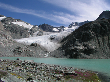
Clues: 1. This glacial lake is surrounded by two shrinking glaciers, one that shares the name of the lake and one that sounds like something that would appear in a house, rather than in nature. 2. In the mid-1800s, a British surveyor named a dominating volcanic mountain peak in the park after a famous 19th century Italian soldier; the park now shares the name with the peak. 3. The main hiking trail leading up to this lake ascends 1,200 meters (almost 4,000 feet) over 7 kilometers (about 4.4 miles), and passes a 300-meter-high (nearly 1,000-foot-high) waterfall along the way. Legend has it that loggers and fishermen created the trail hundreds of years ago.
Name the lake and park. Scroll down for the answer |
| Answer: Wedgemount Lake in Garibaldi Provincial Park in British Columbia is surrounded by the Wedgemount and Armchair glaciers. It is a popular hiking destination, with a 7-kilometer-long trail that climbs 1,200 meters and takes four to six hours each way. Photo by Naomi Lubick. |
April 2005
Winners
Brian Cooper (Huntsville, Texas)
Ben Haravitch (Hemlock, N.Y.)
Jim Jackson (Portland, Ore.)
Anne Jefferson (Corvallis, Ore.)
Bob Kahn (Falls Church, Va.)
Hannah Meckler (Delmar, N.Y.)
Rose Pool (Corpus Christi, Texas)
Norman Smith (Lincoln, Neb.)
Jeff Spooner (Rolla, Mo.)
Ken Sprenke (Moscow, Idaho)
|
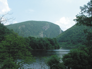
Clues: 1. The main rock formation in this area, of Silurian age, is full of pure quartz, making it highly resistant to erosion. Nonetheless, the deep mountain pass pictured here was carved out of a flat river plain over the past several million years by one of the few remaining undammed rivers in the region. It is one of many ravines formed by wind or water in the high ridges of a long mountain chain. 2. During the most recent ice age, glaciers reached just south of this area and have left behind telltale signs. 3. The park surrounding this ravine is more than 109 square miles and offers outdoor recreational opportunities, including hiking, canoeing and kayaking. Visitors will see remnants of past inhabitants: from native campsites and colonial homesteads to copper mines that were active as recently as the early 1900s.
Name the feature. Scroll down for the answer |
| Answer: Check back next month for the answer and winners of the May Geotimes Where on Earth? contest. |
 |
Geotimes Home | AGI Home | Information Services | Geoscience Education | Public Policy | Programs | Publications | Careers |