
|
 Subscribe

Travels in Geology June 2007 posted June 15, 2007
Panama: Beyond the canal
 Laura Morales |
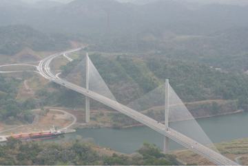
| The Centennial Bridge, built in 2004, crosses the Panama Canal at the Culebra Cut, which marks the narrowest section of the canal. The Culebra Cut required the removal of more than 76 million cubic meters (100 million cubic yards) of rock and soil and runs through the continental divide. |
You probably know that Panama has a canal. The canal is, after
all, one of the most trafficked waterways in the world. It would be a shame,
however, to think of Panama as merely the fastest route between two oceans.
Even a brief visit to Panama reveals that it is a singular destination —
a haven for ecotourists, geologists, history buffs, beach bums, and civil
engineers.
A good place to begin exploring the Central American country is Panama City.
This bustling international hub is a convenient flight destination and will
allow you to travel easily to other sites via the country's inexpensive bus
system or a rented car. The capital's mix of modernity and history is visible
everywhere, but for a particularly poignant example, amble through the ruins
of Panama Viejo. It was one of the first cities in all of the Americas and a
treasury for gold traveling from Spanish conquests in Peru to Spain; today it
looks out at skyscraper scaffolding. Plan to spend a few days exploring the
city's historical sites, as well as the many museums and cultural sites. And
be sure to check out the fantastic local cuisine, which is reminiscent of creole
cuisine — hot and spicy.
 Amadea Britton |
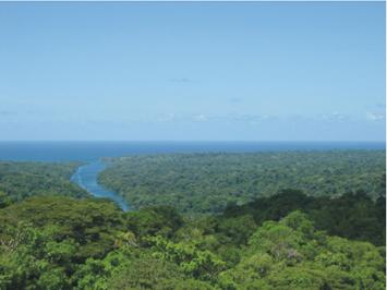
| The Chagres River delta opens out into the Caribbean Sea through dense rainforest. Historic Fort San Lorenzo, most famous for its siege by Captain Henry Morgan, is located at the mouth of the river. |
Although traversing the city can be a vacation in and of itself,
Panama is the place to trade the urban jungle for the greener kind. Panama boasts
extensive protected forests because forests on the canal's edges reduce erosion
and prevent the water from filling with sludgy sediment.
One of the most obvious beneficiaries of this maintenance strategy is Soberania
National Park, which borders the canal. From Panama City, take a taxi or bus
to Pipeline Road, Gamboa, which is in the park, and on the way, stop at the
Culebra (Snake) Cut of the canal; it is the narrowest section and slices directly
through the shale of the continental divide.
When you reach Gamboa, all you need for an astonishing self-guided
bird walk is a pair of binoculars, a Panama birding book, and plenty of water.
More than 300 species of birds live in the park. If you are quiet, expect to
see tropical showpiece birds such as toucans and neon parrotlets. The path is
well-marked, but if you would rather go with a tour, the nearby Gamboa
Rainforest Resort offers guided nature walks and air tram rides above the
jungle, as well as luxurious accommodations, complete with a spa and a collection
of restaurants and bars to fit any mood.
From Gamboa, take a ferry up the canal to Barro
Colorado Island (BCI). Book the boat ride and tour of BCI in advance: It
is well-worth the extra planning to see this geological and biological marvel.
BCI was originally a large hill covered by semi-deciduous rainforest, but in
1913 the nearby Chagres River was dammed and the entire region was flooded to
create a section of the canal. The resultant Lake Gatún, at the time
the largest human-made lake in the world, was dotted by a number of artificial
"islands"— the tops of submerged former hills. The Smithsonian
Tropical Research Institute, a bureau of the Smithsonian Institution, bought
BCI and converted it into one of the most important tropical ecology and biology
research stations in the world. Visitors may see troops of screaming howler
monkeys, sloths, bats and pristine old growth forest free from logging and poachers.
 Amadea Britton |
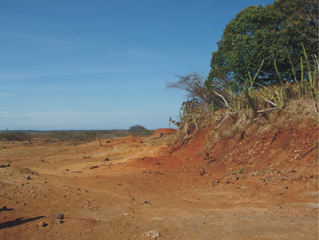
| The eroded edge of shell middens near Chitré on the Azuero Peninsula is all that remains of native inhabitants who lived in Panama thousands of years ago. |
There are a number of other spectacular national parks easily
accessible from Panama City. Take a bus (or train via the scenic Panama Canal
Railway) north to visit the dense forest of the San Lorenzo protected area.
Beware that it is wet almost year-round here so carry a rain jacket. The forest
creeps up to the Chagres River delta, home of the infamous Fort San Lorenzo,
a Spanish defense built in the late 16th century. Spend a few hours walking
around the mossy and crumbling stone and coral battlements. Looking out on the
restless gray waters of the Caribbean, it is easy to imagine a history of piracy
— such as Captain Henry Morgan's 1671 siege of the fort. Rumor has it that
Captain Morgan used the fort as a place to regroup as his pirate crew looted
and pillaged much of Panama that year.
To see a totally different type of terrain, take a bus down
the Pacific coast toward the brown and dusty Azuero Peninsula. Along the way,
fortify yourself with patacones (fried plantains) from roadside restaurants
and food stands. Stop at Altos de Campana, a formation of igneous rock covered
in montane forest with panoramic views of the Pacific, and hike around for a
bit. Continuing along the coast, you will pass El Valle de Antón, one
of the largest inhabited calderas in the world, created in an eruption more
than 3 million years ago. At more than 600 meters (almost 2,000 feet) above
sea level, the elevation of El Valle creates a pleasant year-round climate,
making it a nice place to relax. The town offers a variety of accommodation
options, from hostels to four-star resorts and eco-lodges, as well as some great
hikes. If you have a day or two to spare, plan to take a horseback ride through
the mountains (it's dirt cheap here and offers spectacular views), and spend
a few minutes in the thermal mudbaths. The town is the playground of many of
Panama's richest people.
A bit farther south you will reach a trove of hidden archaeological
gems. The entire region is dotted with stratified pre-Colombian archaeological
sites and often large sloping mounds of earth turn out to be densely packed
shell middens — the great refuse heaps of fishing villages present thousands
of years ago. The middens are filled with shells, stone flakes from carved tools,
fish bones, and even pottery shards.
 Amadea Britton |
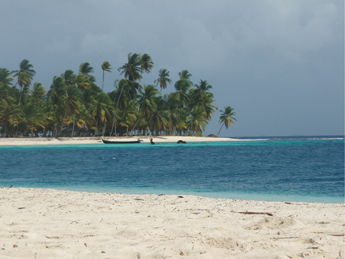
| The Comarca Kuna Yala is an archipelago of more than 360 islands owned by the native Kuna Indians. Many families live on individual islands and interact by boating between the islands. Visitors can hire boats to take them between islands as well. |
When you're ready for a trek off the mainland, take a flight
from Panama City to the Comarca Kuna Yala (San Blas Archipelago), a group of
more than 360 islands in the Caribbean run by the Kuna Indians. From the airport,
hire a guide to shuttle you to one of the remote islands by boat. While a few
hotels can be found on some of the islands, keep in mind that most of the the
accommodations in this archipelago are rustic (often no running water). But
the beaches are dream-like, with healthy fringing reef perfect for snorkeling
and diving (watch out for brightly colored fire coral — it will sting if
you brush against it). The marine species here are different than you would
see snorkeling on the Pacific side of Panama, making a beach trip on both sides
of the country a good idea if you have time.
The Panamanian Isthmus was fully formed about 3 million years ago as the Pacific
Plate slipped beneath the Caribbean Plate. At this point, single species were
divided into two separate groups and underwent separate evolution. Today biologists
use the "magnitude of difference" (both molecular and morphological)
between similar populations of individuals on opposite sides of Panama as a
metric for how fast speciation occurs in the face of geologic barriers and differing
conditions. You can almost see evolution in action.
The best time to see all this is in Panama's dry season, which runs from January
to late April. This is also the busiest season for tourism so plan ahead. But
it is worth it to discover for yourself that Panama is not merely the shortest
distance between two oceans, but rather a distinct place all its own.
Links:
Panama
Tourism Information
Barro
Colorado Island
Panama
Canal
Gamboa
Rainforest Resort
Smithsonian
Tropical Research Institute
Back to top

