
|
 Subscribe

FEATURE
Journeys
Following a Floating Village
Falling for Niagara
Poetry in Stone
 AGI/NASA |
In water-dominated Cambodia, the water cobra, or Naga, is a friendly beast, a mythical creature with multiple heads that symbolizes fertility and prosperity, helps to control rainfall, inhibits evil spirits and generally brings good luck. The Naga, according to ancient Khmer legend, is nothing less than the spirit of the water, land and forests of the Khmer people. Carved in stone, the many-headed Naga is a common feature among the country’s many elegant, thousand-year-old Angkor temples. And in a country so shaped by water, such a creature certainly symbolizes Cambodian life.
Low-lying Cambodia is not likely to be the top vacation destination on any geologist’s “must-see” list. Six thousand years ago, much of modern Cambodia was underwater. It has no volcanoes and few lofty mountains or exposed rock strata. Instead, much of the country is at or below sea level, with the flat horizon interrupted by occasional small hills, called phnoms in Khmer, that are scattered across the country. On one such hill, Phnom Penh, in the southern part of the country, rests the capital.
 Carolyn Gramling |
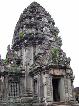
| Sitting deep in the jungle, the temple of Ta Prohm is overgrown with fig and silk-cotton trees, which are slowly pulling it apart, stone by stone. Originally constructed as a Buddhist monastery, Ta Prohm was built by Jayavarman VII in the mid 12th to early 13th century, and was dedicated to his mother. |
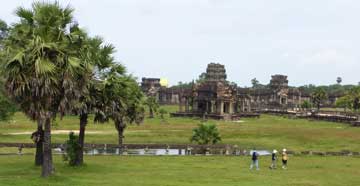
Cambodia’s attraction for historians is more obvious. In the north, near the modern city of Siem Reap, the low landscape is dominated by the graceful temples of Angkor, including Angkor Wat, built when the region was the seat of power of the Khmer Empire from the 9th to the 13th centuries. These temples are a must-see on anyone’s list, geologist or not.
The Angkor temples also mark a high point in the country’s regional power and stability. As their empire weakened from the 13th to 15th centuries, the Khmer fought constantly to keep control of the country, repeatedly struggling with their hostile neighbors. Sandwiched between Thailand to the west, Laos to the northeast and Vietnam to the east, the Khmer periodically were pushed out of power, and the country was often a vassal state of either the Thai or Vietnamese until the late 19th century. At that time, it became a French colony, part of Indochina, and only regained its independence after World War II, when it became a constitutional monarchy. During the Vietnam War, military coups and political instability gave the communist Khmer Rouge rebels the opportunity to start a civil war of their own, eventually seizing power in 1975. Throughout the regime of Khmer Rouge leader Pol Pot, anywhere from 1.7 million to 3 million Cambodians may have been killed. Following a Vietnamese invasion in 1979, a peace settlement was finally reached in 1991 and the country’s reconstruction began.
Despite this recent political instability, as well as the many unpaved roads and even land mines still buried in the countryside, tourism in Cambodia has taken off in recent years, particularly around Siem Reap. Rather than brave the roads between Thailand and Cambodia, take the short, 45-minute flight from Bangkok to Siem Reap’s new airport. From Siem Reap, you can reach the dozens of ancient Angkor temples scattered throughout the region’s forests and farms, at distances of anywhere from 15 minutes to several hours from the city. With no public transportation available, tourists can visit the temples by hiring a car and driver, by tuk-tuk — a type of low, covered rickshaw pulled by a motorcycle — or by bicycle.
 Carolyn Gramling |
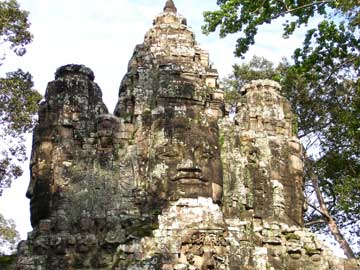
| Bayon temple, situated north of Angkor Wat and built in the late 12th century by Jayavarman VII, is famous for the majestic stone carved faces on its 37 towers, oriented toward the cardinal points. Who the faces represent is still debated, but may be some combination of Buddha and Jayavarman himself. |
But the temples, while spectacular, are not the only attraction in the region, especially to a those interested in geology. Cambodia does have mountains: Two ranges, the Cardamom Mountains and the Elephant Range, skirt the southwestern part of the country, rising to about 1,500 meters (4,900 feet) and 1,000 meters (3,280 feet), respectively. A third range, the Dangrek Mountains, lies between Thailand and Cambodia and forms the northern rim around the Tonlé Sap Basin, reaching elevations of about 700 meters (2,300 feet).
Three-quarters of the country, however, is low-lying and is dominated by the Tonlé Sap Basin and the Mekong Lowlands, which generally lie less than 100 meters (330 feet) above sea level. This has created an unusual hydrological feature that has had a profound effect on its people and economy.
The Tonlé Sap Basin consists of both a lake and a river, so that although tonlé sap translates to “large freshwater river,” it is also often translated as “great lake.” The lake is a long, narrow gash that stretches northwest to southeast across much of the center of the country. Although the lake may simply occupy a depression created during the collision of the Indian subcontinent with Asia, another idea about how this water-filled basin was formed holds more mystery. Some scientists have hypothesized that the elongated lake formed during the slanted impact of a comet or asteroid, which may also be the source of a well-known group of tektites, or melted meteorites, found scattered across Australia and southeastern Asia. However, even after a 1992 expedition dedicated solely to searching for telltale signs of impact around the lake, the crater hypothesis has yet to be substantiated.
 Carolyn Gramling |
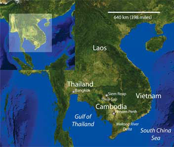
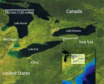
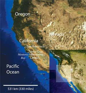
| Although Angkor Wat is the best-preserved and most spectacular of the Angkor temples, dozens more dot the landscape of Cambodia, which sits at the southern tip of Southeast Asia (map, above). |
To the east of the Tonlé Sap Basin flows the Mekong River, which has its origin in Laos and flows south into Vietnam’s Mekong Delta. The Mekong cuts across the eastern half of Cambodia and connects to Tonlé Sap Lake via the small river also called Tonlé Sap. For much of the year, Tonlé Sap Lake is perhaps no more than a meter deep, and covers an area of about 2,700 square kilometers (1,042 square miles). During the dry season from early November to March, the lake drains gently into the Tonlé Sap River, which in turn drains into the Mekong River — sometimes called “the mother of Southeast Asia.”
When the monsoon rains begin, however, the mighty Mekong begins to swell, and, under the pressure of its waters, the Tonlé Sap River reverses direction and pours back into the lake. By October, at the height of the monsoon season, Tonlé Sap Lake can grow to more than four times its dry season area and become as much as nine meters (30 feet) deep, inundating surrounding forests and rice paddies, and creating one of the most productive inland fisheries in the world. Fish from the lake supply more than three-quarters of Cambodia’s annual inland fish catch.
 Carolyn Gramling |
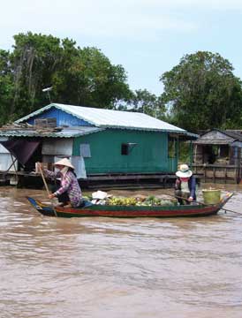
| In the floating village of Chong Kneas, villagers ferry fruit and vegetables between the barge and boat houses by canoe. |
The flooding creates a landscape always in flux, with a constantly changing shoreline. It is one of the most unusual ecosystems in the world, designated by the United Nations Educational, Scientific and Cultural Organization (UNESCO) in 1997 as a biosphere reserve, or a region that encompasses multiple protected ecosystems.
The shifting waters have also given rise to a unique floating village that follows the water’s movement. Chong Kneas is almost entirely afloat, a constantly moving, shape-shifting cluster of barges and boats filling the meanders of Tonlé Sap River. Rows of precarious-looking stilt houses line either shore, connected by the shallow canoes that travel back and forth between them.
When I traveled to Cambodia in early August 2006, Tonlé Sap Lake was already swelling and the village was bustling. Off the starboard bow of our long, shallow tourist boat, two villagers steered canoes loaded with fruit and vegetables between makeshift floating homes. Behind one such house, curtained for privacy with bright pink and orange polyester scarves, a floating wooden cage containing three pigs tilted into the water as the pigs stood close together at one end of the box. On our port side, a villager meticulously moved among car batteries spread out in even rows across the deck of a wide barge. Puzzled, we turned to our guide, who told us the barge is a battery charging station. The car batteries power what few appliances the villagers have — and explain the incongruous presence of occasional TV antennae attached to some roofs.
The floating village of Chong Kneas is a living reminder of how significant water is to Cambodian life. Archaeological evidence suggests that even 3,000 years ago, people in the region lived in houses built on stilts and subsisted on a diet of fish and cultivated rice. Still, it is in the realm of mythology that perhaps the most powerful connection between Cambodians and water is made: Legend tells that the Cambodian people decended from the union between an Indian Brahman and the daughter of the king of the Naga, the snakelike water spirits. The Cambodians, it seems, once born of water, will never be far from it.
 AGI/NASA |
Straddling the border between the United States and Canada is one of North America’s most magnificent natural sites: Niagara Falls. Standing on either side, you can’t help but be captivated by its beauty. Water plunges 17 stories from its crest to a swirling pool at its bottom. And at night, lights with ever-changing colors illuminating the falls are as mesmerizing as a lava lamp.
Niagara Falls is a short 20-minute drive from Buffalo, N.Y., or less than hour’s drive from Toronto, Canada. On the Canadian side, the town of Niagara Falls is quite developed, with countless hotels, restaurants, kitschy tourist shops, golf courses and amusement-park-style ways to enjoy the area, including behind-the-falls boat tours and helicopter tours. Science museums tell the glacial history of the region, and numerous park trails allow visitors access around the falls. For centuries, this tower of water has drawn travelers from afar, including families, honeymooners and daredevils who thought it was a good idea to go over the falls in a barrel. Niagara Falls is not just a natural beauty; it is a cultural icon.
But Niagara’s wonder isn’t limited to its water. If you truly want to appreciate the natural history of the area, hike through the Niagara Gorge Trail System on the U.S. side. Stop by one of the tourism offices to get a trail map or download one from the Web before you go. And bring sturdy shoes, as the hikes through this area can be steep and rocky. Traversing the trails is worth the trouble, however, as they provide exceptional snapshots of ancient life from the Ordovician period about 450 million years ago.
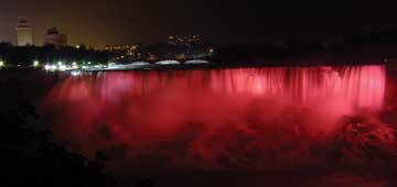
| At night, the falls are lit up in a display as bright and colorful as New York’s Times Square. |
Shallow tropical seas once covered the area, along with most of North America, says Jorg Maletz, a geologist at the University of Buffalo, N.Y. Remnants of ancient life can be seen in geologic succession throughout Niagara Gorge, including such locations as Whirlpool State Park, the trails through the town of Lewiston, N.Y., and Devil’s Hole, which used to be a waterfall and is now a dry, empty amphitheater that offers a terrific place to study how the force of waterfall can erode the rocks and soil around it, Maletz says.
Niagara Falls’ 450-million-year-old red shale is topped by beach-type sandstone, overlain by successive layers of shale, sandstone and finally 440-million to 420-million-year-old dolomite, a hard carbonate rock. This dolomite is the “caprock,” or top resistant layer, for Niagara Falls and contains a plethora of fossils, including everything from the seemingly ubiquitous trilobites to brachiopods, graptolites, echinoderms and other ancient marine critters. In fact, just a few minutes up the road in Lewiston is Art Park, where visitors can actually collect these fossils.
Compared to its stone and fossil foundation, Niagara Falls is pretty young. The falls, a remnant of the last glacial advance, have existed less than 12,500 years, Maletz says. Ontario and much of the upper Midwest and Northeastern United States were covered by ice sheets 2 to 3 kilometers (1 to 2 miles) thick about 18,000 years ago. As the glaciers moved south, they carved out huge depressions tens of kilometers wide. When the glaciers melted and retreated, their water filled the basins and they became the Great Lakes. By 12,500 years ago, the Niagara region was iceless and water began to flow from what was then Lake Erie into Lake Ontario via the Niagara River, which provides the only outlet for the Great Lakes to the Atlantic Ocean. The resulting waterfalls, although not the tallest falls in the United States and ranking somewhere around 500th tallest in the world, are renowned for their width and sheer volume of flowing water.
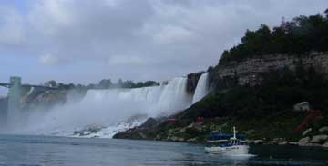
| One of the most powerful waterfalls in the world, Niagara Falls straddles the border between the United States and Canada. |
Niagara Falls is “a dramatic, spectacular sight,” Maletz says. You should plan to see the falls from both the U.S. and the Canadian sides — but the Canadian side, while far more developed, does offer the more impressive views. The falls are made up of three separate waterfalls across the Niagara River: the American Falls, Bridal Veil Falls and Canadian or Horseshoe Falls. Some 70 percent of the water flows over Horseshoe Falls, which stretches 670 meters (about 2,200 feet) across and accounts for two-thirds of the width of the falls. During peak tourist hours, roughly 168,000 cubic meters (six million cubic feet) of water pours over its crest every minute. This is 5,700 cubic meters, or more than 200,000 feet of water per second. (The 1950 Niagara Treaty, which regulates water diversion over the falls, dictates that that peak water flow matches peak tourist hours. During nonpeak hours — after 10 p.m. during the summer or 8 p.m. in the fall — more water is diverted to various other users, including several hydropower plants.)
While the water cascades over the falls and into the Niagara Gorge below, it quickly picks up speed, occasionally reaching 9 meters (30 feet) per second as it gushes into an area known as Whirlpool Rapids. These rapids stretch for about 1.6 kilometers (1 mile) long beneath the falls, and end spectacularly in a churning whirlpool 518 meters (nearly 1,700 feet) long by 365 meters (about 1,200 feet) wide. Whirlpool State Park in New York offers good views, Maletz says. And for a fee, you can take a walk right down to this churning whitewater whirlpool.
One caveat before you travel, however: Don’t plan for Niagara Falls to always be there, Maletz says. The falls are some of the fastest eroding waterfalls in the world, dissolving the soft shale beneath the dolomite at a pace of up to a half a meter every year. Eventually, the powerful water will have worn enough of the landscape that, without its stony base, the falls itself will disappear. But not to worry, that’s not likely to happen for another 30,000 years or so, Maletz says. So brush up on your Ordovician and Silurian critters, grab a hiking map and some sturdy boots, and pack everyone up for a trip. The 15 million people who admire Niagara Falls each year can’t be wrong.
Meanwhile the image of the pristine beauty From “Carmel Point,” by Robinson Jeffers |
 AGI/NASA |
The western edge of North America is geology at its most basic: fluid versus solid, uplift versus erosion. Few places exhibit this dynamic as beautifully as California’s Highway 1 when traveling south from Carmel-by-the-Sea. Skirting the steeply sloped hillsides of the Santa Lucia Mountains, the road reveals new beauty at each bend. Over one headland, you look south for kilometers, watching waves break on granodiorite and mudstone, transported northwest over hundreds of kilometers along the San Andreas Fault zone. At the next bend, you see the Bixby Bridge rising nearly 80 meters (more than 260 feet) over a verdant ravine. Beside the shore are sea stacks, towers made of rocks that are at least 60 million years old. These wear-resistant cores of rock are the land’s last stand against the ocean.
But this area of California has much more to offer than what is found along a single, captivating highway. It also has spectacular geologic formations and fossils. Three groups of rocks make up the Salinian block, a northwest- trending terrane, bound on the east by the San Andreas Fault and on the west by the Sur-Nacimiento Fault. Of these rock groups, the oldest is the Sur Series, a group of metamorphic rocks that date to the Paleozoic era, or about 560 to 250 million years ago. Then, about 100 million years ago, salt-and-pepper speckled magma intruded into these metamorphosed rocks. Recent geologic studies have designated these old speckled rocks as Santa Lucia granodiorite, porphyritic (course-grained) granodiorite of Monterey at Point Lobos or hobnail granite. The last name refers to tabular, white feldspar phenocrysts, some up to 10 centimeters (about 4 inches) long.
Forty million years later, after uplift and erosion had exposed this granodiorite, turbidity currents (rapidly moving, sediment-laden water) deposited 60-million-year-old sedimentary rocks on top. This Carmelo Formation consists of gray mudstones, tan sandstones and tawny conglomerates containing granodiorite boulders up to nearly 3 meters (almost 9 feet) wide. Mudstones of the Carmelo Formation bear fascinating feathered and serpent-like tracks of ancient marine animals, or trace fossils, some up to nearly 2 meters (more than 6 feet) long by 22 centimeters (about 9 inches) wide.
About 27 million years ago, the Pacific Plate began to carry the Salinia north, along the San Andreas Fault. Geologists believe that Salinia once occupied a mountainous region between the Sierra Nevada and the Peninsular Ranges in Southern California, although some still place Salinia’s origins between 2,400 and 5,600 kilometers (about 1,500 and 3,500 miles) south, in southern Mexico.
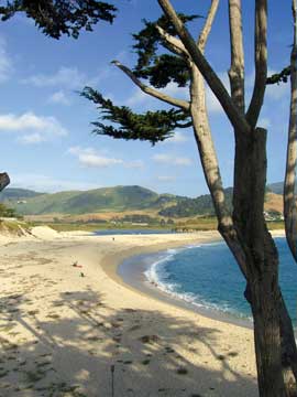
Point Lobos State Reserve is the best place to see these motley groups of rocks, as well as Monterey pines and cypress, California sea lions, sea otters and nesting Brandt’s cormorants. Just south of Carmel, the park is threaded with more than a dozen trails that traverse rock, meadow and forest, and provide easy access to water, beach and headland. Be aware that parking is limited and when lots fill, entry may be limited. Although a staircase at the trail’s end leads to an excellent exposure of the Carmelo Formation, note that only the Sea Lion Point Trail is wheelchair accessible. Of the reserve’s other sites, a whaling station thrived off Whalers Cove from 1862 to 1879. Hidden Beach, with its convolutedly eroded mudstones that look like they are covered in paintings of canyons, is a short walk from the Bird Island Trailhead. Nearby Weston Beach has the richest exposures of trace fossils, which have been recently interpreted as the result of mollusks moving through the mud.
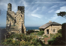 Jessica Malikowski/Tor House Foundation |
| Poet Robinson Jeffers helped build Tor House and then built Hawk Tower (above) from rocks collected from the beach at Carmel Bay (below). This was the family’s home until 1978, when the Tor House Foundation took on its care as a historic landmark. |
 Burghardt Advertising |
Located more than half a kilometer (about a third of a mile) south of Carmel’s beautiful beach, Tor House and its accompanying Hawk Tower rise from a low bluff, all overlooking the ocean. Poet Robinson Jeffers helped build the house in 1919, and then went on to build Hawk Tower by himself from 1920 to 1925. He built them for his wife and two children, naming the house for the craggy knoll, or tor, on which it rested. However, these granodiorite-clad structures don’t seem to be constructed as much as appear to grow from the hillside, as if Jeffers had used the nearby cliffs, sea stacks and outcroppings for blueprints. Up close, they are geology manifest — no two blocks are alike, and rarely do stones of the same size rest next to each other. Edges are not perfectly straight but look weathered and eroded. Barnacles still cover some of the stones Jeffers liberated from the sea. Finger trails run through the mortar — trace fossils of a man and his passion.
Working with rocks he collected from the beach below, Jeffers mixed small, large and immense boulders in a seemingly random but actually intentional pattern. He anchored a corner of the guest room at Tor House on a mass of bedrock, which he called Thuban in honor of a faint polar star. He spanned one window with a colossal boulder, another with a row of square rocks, and over the main entrance to Hawk Tower, he placed a perfectly shaped wedge as a keystone. In an homage to Tor House, Jeffers wrote, “My fingers had the art to make stone love stone.”
Tor House was the family home. Dark, redwood paneling gives the main room a somber feel, enhanced by the cloudy light that comes through the large west window and smaller south windows. Fire has blackened the once-tawny sandstone of the fireplace, which dominates the north wall, between two doorways. One of these doorways leads to a small bedroom and the other to the former kitchen and dining room. Here, Jeffers and his wife, Una, entertained famous visitors, including Charlie Chaplin, Charles Lindbergh and George Gershwin. They would have been warmed by the massive fireplace, as well as by homemade wine, fermented from oranges, raisins and rice.
Across a small, flower-rich garden is Hawk Tower, which rises more than 12 meters (40 feet). Jeffers built it for Una, who had loved similar towers she had seen in Ireland. The lower walls are 1.8 meters (6 feet) thick with stones that weigh up to 181 kilograms (400 pounds). Jeffers moved each one himself, at first using a long incslined ramp to raise them and then a pulley-and-hoist system.
Within seven years of finishing Hawk Tower in 1925, Jeffers was one of the most well-known poets in the country, even becoming the first poet to appear on the cover of Time magazine. Both in short verse and epic, book-length poems, he recognized and expressed — like few other poets have — the distinct connection between people and landscape, and how each influences the other. For Jeffers, this connection was grounded in his stunning Carmel homestead. In the conclusion to his Tor House poem, he wrote: “My ghost you needn’t look for; it is probably here, but a dark one, deep in granite.”

