
|
 Subscribe

FEATURE
Summer Road Trip: Driving Across the Northern United States
Callan Bentley
 Callan Bentley |
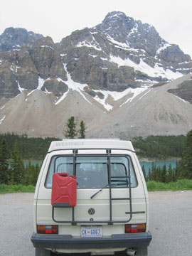
| Author Callan Bentley drove from Washington, D.C., through Canada — shown here in Alberta — to Alaska and back. |
One summer, Callan Bentley, a geologist at Northern Virginia Community College in Annandale and a Geotimes contributing writer, trekked across North America in his Volkswagen Westfalia camper van and lived to tell about it. Over a three-month period, he journeyed from Washington, D.C., to central Alaska and back. When he came across interesting geology, he used the van’s solar power to fire off a dispatch for Geotimes. The following is part of his roadtrip series, the full length of which can be found on Geotimes online in our “Travels in Geology” section, at www.geotimes.org/Travels.html.
Driving to “West Dakota”
Those with an interest in all things geologic should make a point of visiting western South Dakota and eastern Wyoming. Four hours of driving through Badlands National Park, the Black Hills and Devils Tower takes the geo-philic traveler through a region that has much to entertain.
Let’s imagine that you’re driving from east to west (as I did). Right away, roadside billboards advertising Wall Drug besiege you on Interstate 90. Wall Drug, located in Wall, S.D., isn’t really of geological interest, but it is a labyrinthine collection of stores, kitsch and eateries that boasts, among other attractions, an animatronic Tyrannosaurus rex that commemorates the area’s former residents. It’s worth a stop just to watch this lethargic T. rex “roar.”
Also in the town of Wall, but neglected by comparison, is the visitor center for the National Grasslands, 4 million acres of publicly owned prairie administered by the U.S. Department of Agriculture. There you can find information on nearby Buffalo Gap National Grassland and more about the entire system of public lands in the area.
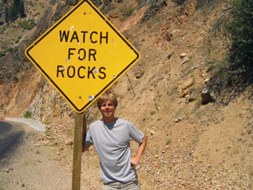 Courtesy of Callan Bentley |
| Callan Bentley stands by his motto — watch for rocks. |
South of I-90 is Badlands National Park, an excellent example of a characteristic “badlands” landscape. Badland formations, with their steep canyons and gullies, colorful rocks and soils and, frequently, fossil beds, are found in several locations in the United States and Canada. These landscapes form in arid locations, where loosely cemented sediments are eroded by periodic intense rainfall. In this national park, sediments range in age from Cretaceous (145 million to 65 million years ago) to Miocene (23 million to 5 million years ago). The oldest deposits are associated with the Western Interior Seaway, a body of seawater that stretched from the Gulf of Mexico to the Arctic Ocean from about 140 million to 60 million years ago. In the outcrops, some of which you might be able to see on hikes through the park, fossils of Baculites mingle with vertebrates like flying, fish-eating pteradons, sea-monsterish mosasaurs and the giant turtle Archelon.
The area is also rich in fossils from the early Cenozoic, including a treasure trove of mammals from the Oligocene (34 million to 25 million years ago). One favorite site is the “Big Pig Dig,” a site from which fossils of an ancient pig relative called Archaeotherium have been extracted. Alongside Archaeotherium, the dig contains ancient camels, rhinos, dogs, horses and even a boa constrictor. Fossil casts, videos and life-sized reconstructions of all of these critters are on display in the excellent Ben Reifel Visitor Center near Interior, S.D. A superb stratigraphic display describes how each geologic layer was deposited and what fossils it contains.
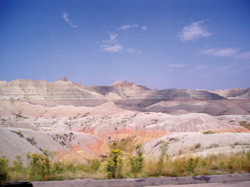 photo by Megan Sever |
| The Badlands of South Dakota offer much to the geophilic traveler. |
When the Badlands have finished working their arid magic on you, it may be time to head for the hills. Higher and cooler than the surrounding Great Plains, the Black Hills appear “black” because of the dark color of the coniferous trees on their flanks. Geologically, the Black Hills are actually a massive upwarping of rock layers that arched to form a dome. The uppermost (youngest) layers of rock have been breached at the center of the dome, so that the underlying granite core is exposed, and is surrounded by a bulls-eye ring of sedimentary rocks.
To learn more about the hills, spend an hour or two at the South Dakota School of Mining and Technology’s museum in downtown Rapid City. Watch out for motorcycles, though: Nearby Sturgis, S.D., is host to an annual gathering of Harley-Davidson enthusiasts, which ensures that year-round, loud “hogs” throttle through the streets of Rapid City. It’s also one of the few towns in the area that hosts a lot of hotel and restaurant options, should camping not be your style.
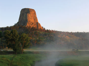 courtesy of Callan Bentley |
| Devils Tower in Wyoming is an intrusion of igneous rock that exhibits terrific examples of columnar jointing. |
The Harney Peak granite, at the center of the Black Hills, is the raw material from which nearby Mount Rushmore and the Crazy Horse Memorial were carved. Though a tourist trap, Mount Rushmore is likely to be particularly visually appealing to geologists, who may spot the dikes of lighter colored granite arcing through the presidents’ faces, and the contact between the granite and darker-colored schist and gneiss at the base of the mountain (about halfway down George Washington’s chest).
Driving west into northeastern Wyoming, a final stop in this area might be Devils Tower. Carved out of the surrounding sediments by the Belle Fourche River, Devils Tower is a delightful place to visit — very quiet and peaceful, a world apart from the mêlée at Mount Rushmore. The iconic column of igneous rock was not only the backdrop for Stephen Spielberg’s Close Encounters of the Third Kind, it is also a world-class example of columnar jointing. In these formations, liquid magma contracts as it cools, and the resulting cracks split the solidifying magma into tall, multifaceted columns of rock.
The Devils Tower magma solidified between layers of Jurassic and Triassic sandstones and siltstones approximately 50 million years ago. Few experiences can be more satisfying than contemplating a great stump of rock in the warm light of sunset.
Wyoming’s Fossil Aquarium
As they were in life, Green River Formation fossil fish are everywhere — you can find the beautiful, iconic and relatively inexpensive fossils in nature stores, museums, private collections and geology departments throughout America. The size of a chocolate bar, a typical Green River Formation fossil fish looks like a dark brown etching on a tan background, making them easy for amateur collectors to identify. Professional paleontologists also venerate them for their incredible detail: In most fish fossils, only bones are present, often strewn about in a disarticulated mess. But Knightia (a herring, the most common Green River fossil) and its kin display scales, teeth and fins, all exactly where they would be in a living fish.
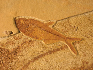 courtesy of Callan Bentley |
| Knightia is the most common fossil in the Green River Formation of Wyoming and is exposed at Fossil Butte National Monument. |
The fossil fish come from the southwestern corner of Wyoming, near the Utah and Colorado borders. An area of dry upland sagebrush today, the fossil site doesn’t look like a great place to go fishing. But 50 million years ago it was the center of a large aquatic ecosystem. In the basins of three large lakes (including aptly named Fossil Lake), fine-grained siltstones and freshwater limestones recorded the creatures living there at that time. Fossil Butte National Monument, near Kemmerer, Wyo., exhibits some of the finest exposures of the Green River Formation.
The National Park Service maintains a free museum at the site, where visitors may view an entire ecosystem that was preserved in the Green River Formation. In addition to fossil fish, the formation yields reptiles such as turtles and crocodiles, and at least one snake. Other fossils show insects, crayfish and freshwater shrimp, sketching the fine details of these small, delicate organisms: antennae stretched out for several inches, or the delicate lace of veins in a dragonfly’s wings. Leaves of shore-bound plants also abound, especially sycamore trees and fan-palms. Even flying creatures like birds and bats that fell into Fossil Lake were preserved.
If the sun isn’t too hot, several hikes offer another good way to take in the site. One trail winds through the upland portion of the park, featuring modern plants and animals. Visitors can also hike to the main area where fossils are excavated. On Saturdays, the park offers an additional bonus: a participatory program called “Aquarium in Stone,” where visitors help to quarry fossils. Because it is a national park, visitors cannot keep the fossils they find, but the rangers do issue a certificate bearing each sample’s museum I.D. number and recognizing the visitor’s contribution.
Outside of the Fossil Butte National Monument, several local commercial operations work their own exposures of the formation. For a fee, visitors can participate in the quarrying of fossils, and they actually get to keep what they find. (The state of Wyoming, however, retains any “rare and unusual” fossils, such as stingrays, gar fish, mammals and birds.)
Ferrying through the Inside Passage
Travel, some would argue, is more about the journey than the destination — and whether by car or by boat, it’s a pleasure to take the slow route. A road trip is certainly a throwback to times before frequent flyer miles and high gas prices: You navigate a landscape, and deliberately take the long way so you can experience something new.
Perhaps nothing is more contemplative than a boat ride. In case you think “boat” and “road trip” don’t mix, you should learn about the Alaska Marine Highway, a system of ferries that connects the coastal towns of southern Alaska to the outside world.
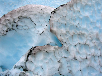 Lisa Dean |
| Glaciers are one of the first things to notice on your ride southward along Alaska’s Inside Passage. Glacial ice in the passage is a weird, glowing shade of blue: unbelievable until you see it for yourself. |
After logging 16,000 kilometers in my van, the last of which (across the Yukon portion of the Alaska-Canadian Highway, or AlCan, on the way to Alaska) were the worst, it was with distinct pleasure that I drove onto the M.V. Columbia and set the emergency brake. It is a four-day ride on the ferry from Haines, Alaska (or nearby Skagway), to Bellingham, Wash. (a little over an hour north of Seattle).
This is the Inside Passage, a coastal route that meanders through waters dividing the mainland from the Alexander Archipelago, a suite of 1,100 islands along the coast of southeast Alaska and British Columbia. Seasickness is rarely an issue in the passage, as the islands block the rougher waves of the Pacific Ocean to the west.
The ferry ride is not cheap, however: In addition to your personal transport ticket, you’ll pay extra for both vehicle and stateroom (if you choose to get one). The total bill for two people, one room (with private bath) and a van is close to $2,500. If you don’t want to splurge on a stateroom, you can camp on the ferry — just remember to bring lots of duct tape if you do, because tent stakes don’t work on a metal deck.
A U.S. Forest Service representative acts as the shipboard naturalist, giving talks about the land, wildlife and native cultures. If you need a non-nature distraction, there’s a movie lounge (equipped with recliner chairs), an arcade, a snack bar, a sit-down restaurant and a cocktail lounge. The bar is possibly the most singularly Alaskan aspect of the ship: I challenge you to name another municipal “highway system” that features its own bartender and velvet Elvis paintings on the wall.
Traveling the Inside Passage from north to south, as I did, the first things to notice are the glaciers. The rocks of coastal Alaska are just now emerging from the last ice age, and large ice caps and valley glaciers are still quite evident. In “nearby” Wrangell-St. Elias National Park, the Malaspina Glacier alone is larger than the state of Rhode Island. As the glaciers melt, they retreat into U-shaped valleys, which fill with seawater to become fjords.
The ferry’s trek begins in Lynn Canal, the longest and deepest fjord in North America — more than 600 meters deep in places. It is a magical sight: Hanging glaciers suspended above the fjords provide spectacular waterfalls. Rainbow Glacier, southeast of Haines, is one such sight: The glacier hulks, big and weirdly blue, high above the passage.
Like Alaska’s people, most of its rocks started off somewhere else. Alaska is composed of a great many puzzle-pieces called terranes, bits of crust that were detached from their original locations by tectonic forces, which then rafted the pieces up to their current locations sometime in the past 200 million years. Shuffled along via the faults of the Queen Charlotte Fault System (a northern equivalent to California’s San Andreas Fault), these terranes have been added piecemeal to North America.
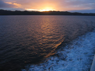 Callan Bentley |
| For four memorable days on a ferry from Alaska to Washington, water, islands and sky combine to create a scenic panorama that is constantly changing. |
In addition, new crustal material is still being generated on the spot. From the town of Sitka, passengers can gaze west at the slopes of the Fuji-shaped Mount Edgecumbe, a young volcano. The mountain is a tectonic oddity: Usually, volcanoes are located at subduction zones, but Edgecumbe is part of a field of similar volcanic vents located a mere 25 kilometers from the Queen Charlotte Fault, a transform fault. One possible explanation is that a minor fault within the Queen Charlotte system acts as a pipe, funneling magma upward to the surface.
In 1974, a prankster lit a pile of tires in Mount Edgecumbe’s summit caldera, triggering fears in Sitka that the volcano was erupting. That was a false alarm but the mountain has erupted as recently as 200 years ago. A noticeable layer of grey ash in the Sitka soil profile is evidence of another eruption 9,000 years ago.
The town of Wrangell, another stop on the ferry’s route, is a good place to disembark and examine the gorgeous phyllite of the Taku Terrane. This silvery metamorphic rock is studded with enormous, perfectly formed garnet crystals. The site once hosted a mine operated by the Alaska Garnet and Manufacturing Company, the first corporation in the world staffed entirely by women.
Between Wrangell and Ketchikan is Prince of Wales Island, the third largest island in the United States. There, the rainy weather has dissected a significant amount of limestone out of the Alexander Terrane, yielding a “world-class example of karst topography,” says shipboard naturalist Brenna Campbell of the Tongass National Forest. According to Campbell, places on Prince of Wales Island feature between 3,000 and 10,000 sinkholes per square mile, easily the highest such concentration in North America.
The island’s caves have yielded bones of Pleistocene species like the ringed seal and arctic fox, which shifted southward during the last ice age but are now found only far to the north. In addition, a human jawbone, radiocarbon dated to be about 10,000 years old, was found in On Your Knees Cave. This date almost doubles the previous estimates for how long people had been living in southeast Alaska, and raises the possibility that some human cultures may have migrated south into the “Lower 48” via the coasts, rather than by an inland route.
Alaska is a land of superlatives. Exiting the biggest state in the union by ferry is a great way to go: lingering and contemplative. On my four days aboard the Columbia, I spent many hours just staring out the window at the rainy, forested maze of islands. Traveling along a coast so naked and wild, uncomplicated by cities, is an opportunity to get a real sense of the huge, beautiful continent on which we live.
Links:
"Travels in Geology," Geotimes online

