
|
 Subscribe

NEWS NOTES
Turning Iraqs water back on
 U.S. Geological Survey |
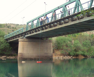
| Engineers from Iraq’s Ministry of Water Resources measure stream discharge from a bridge across a tributary of the Tigris River in Dokan, Iraq. |
Decades of war have ravaged Iraq’s complex water management system. But new technology and training from U.S. agencies, including the U.S. Geological Survey (USGS), are helping Iraqi engineers to get the water flowing again.
Iraq’s famed Tigris and Euphrates rivers, which define the geographical region of Mesopotamia, have shaped much of the area’s history for thousands of years. Sometimes called the “Cradle of Civilization,” the fertile land between these rivers gave rise to the ancient Sumerian culture more than 7,000 years ago. The rivers’ penchant for spring floods helped the Sumerians develop irrigated fields, farming and year-round agriculture.
Indeed, irrigation is a legacy of the region. The Iraqis have “a long history of managing [their] water resources,” says Stephen Lipscomb, a USGS hydrologist in Boise, Idaho. By 1980, he says, they had developed a complex system to manage water for flood control, irrigation and hydroelectric generation.
But over the past three decades, Iraq has been mired in a series of wars, and the country has also suffered under heavy embargoes. As a result, much of Iraq’s once-effective water management system has “fallen into disrepair,” Lipscomb says. That has had implications not only for agriculture and power generation (Baghdad residents currently have consistent power from the national grid for perhaps two to four hours each day), but also for forecasting periodic floods. Iraq’s water gauging stations were all manual: To keep close watch on flooding on the Tigris River, for example, “you would have to send a person out to the river once a day to read a gauge pounded into the side of a riverbank,” Lipscomb says. “They’re trying to figure out when [the floodwaters are] going to crest, so that people can plan accordingly and save property and lives. And they’re relying on this very antiquated system.”
In 2004, a year after the U.S.-led invasion of Iraq, the U.S. State Department, via the U.S. Agency for International Development (USAID), recognized the urgent need to improve the country’s water management infrastructure, which meant both updating the technology and bringing Iraq’s Ministry of Water Resources engineers up to speed on how to use it. To train the engineers, USAID contacted both the USGS international water branch and the Army Corps of Engineers.
In 2005, Lipscomb and James Hathorn of the Army Corps headed to Dokan, in northern Iraq. They brought with them two pieces of equipment: an automated water gauging station that could be hooked up to a satellite telemetry system (which both automatically uploads data via satellite and allows the engineers to remotely retrieve data) and an acoustic Doppler current profiler that could take river depth and water velocity measurements. The training lasted one week, after which they left the equipment behind.
They returned again for two weeks in 2006, bringing more equipment and a larger team and training the engineers to install a second gauge at a station on the Tigris River near the Syrian and Turkish borders. As the project continued, a team from Italy’s Ministry of Environment and Territory became involved as well, focusing particularly on helping with efforts to restore the ravaged marshlands of southern Iraq. Those marshlands, the largest wetland ecosystem in the Middle East, were badly damaged by upstream dam construction and drainage under the regime of Saddam Hussein. The limited flow of water (as well as poor water quality management) resulted in high salinity, sewage contamination and high concentrations of pollution from pesticides and untreated industrial discharge — a particularly acute problem for residents of southern Iraq who rely on the marshes for drinking water and agriculture.
But the agencies recognized that a few weeks of training on the new, sophisticated technologies weren’t going to be sufficient. So in the fall of 2007, two groups of Iraqi engineers traveled to Boise to spend several weeks in training with USGS and Army Corps scientists and engineers.
To date, Lipscomb says, the State Department (with the assistance of the Italian government) has purchased about 100 real-time water quality gauging stations that are now being installed throughout Iraq, particularly along the Tigris and Euphrates rivers and the large canals that channel water for irrigation. A new satellite ground station in Baghdad will also enable the country to receive its first satellite data from the new gauging stations this summer. “Currently, there are five [stations] up and running, and they’re eager to get the remaining ones installed,” he says. “It’s going to take some time; if they could get all the remaining gauges installed and running over the next five years, they’ll have done a good job.”
Security issues prevent U.S. engineers from being onsite for most of those installations, and they can only help from afar, which can be frustrating, Lipscomb says. Following the installation of the first two gauges in the less war-torn northern part of the country, the next three were installed in the south by Iraqi engineers alone. “There were many e-mails and phone calls; that made it very difficult,” Lipscomb says. “We spent three months resolving what would have been a simple problem if we could have been onsite. But it’s a learning curve for them.”
Lipscomb is quick to note that Iraq’s engineers are skilled in their understanding of water management, with a thorough knowledge of their country’s river systems. What USGS is providing is technological assistance, he says. “It’s not like we’re coming in there and showing them how to do things from scratch. They’re just hamstrung by a lack of technology, which their country has not invested in over the last 30 years. But they’ve been doing this for a long time.”

