Ernest Rutherford, Nobel Prize winner in chemistry in 1908, observed that:
“All science is either physics or stamp collecting.” While this assessment
may be an affront to scientists of many persuasions, most scientists have an
appreciation for the sentiment: Modern science is expected to go beyond genteel
sorts of observations and descriptions of phenomena (“stamp collecting”)
and explore the reasons why things are the way they are (“physics”).
If there is a single litmus test for modern science, it is whether possessing
understanding provides not only a description of past events but also the basis
for prediction of the future.
Prediction is an area of frustration to seismologists. Our inability to predict
events, after all, can lead to future disasters, as the world just witnessed,
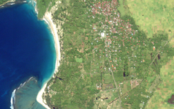
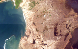
when a powerful earthquake struck in the Indian Ocean, causing a tsunami that
left hundreds of thousands dead (see sidebar).
The science, however, is not without predictive capability. We can now, for
example, predict with a fair measure of certainty how the ground will shake
during an earthquake on a given fault. But predicting exactly when and where
an earthquake will strike remains an elusive beast, always hiding just around
the next corner. This inability generates frustration among the public as well.
In contrast to economics, where predictions are constantly wrong and right in
equal measure, people look to earthquake scientists to take away the harrowing
element of unpredictability, and tend to apply a zero-tolerance standard to
emerging earthquake prediction efforts.
Waves of optimism
The earthquake prediction pendulum has swung from optimism in the 1970s to rather
extreme pessimism in the 1990s. Earlier work revealed evidence of possible earthquake
precursors: physical changes in the planet that signal that a large earthquake
is on the way. Using such precursors, the 1975 Haicheng earthquake in China
was predicted, saving untold thousands of lives. The prediction was almost entirely
based on an unusually prodigious sequence of foreshocks over several months
prior to the mainshock. When the magnitude-7.8 Tangshan earthquake struck northern
China, not far from Beijing, a year later, it had no such foreshock sequence,
and was not predicted. Estimates of the death toll from that event range from
250,000 to as high as 750,000.
Over time, scientists grew increasingly discouraged about relying on these precursors.
At the same time, a new scientific paradigm emerged and did not bode well for
earthquake prediction: chaos theory. According to these theories, large physical
systems behave in complex and often unpredictable ways. A small disturbance
in a sand pile, for example, can cause either a small avalanche or a large one,
depending on innumerable factors that can never be known in advance.
Some respected earthquake scientists argued that earthquakes are likewise fundamentally
unpredictable. The fate of the Parkfield prediction experiment appeared to support
their arguments: A moderate earthquake had been predicted along a specified
segment of the central San Andreas fault within five years of 1988, but had
failed to materialize on schedule.
Other scientists perhaps remained more open-minded, but concluded nonetheless
that research dollars would be better spent on studies to mitigate earthquake
hazards. From a practical standpoint, even if earthquakes could be predicted,
buildings and other infrastructure would still have to withstand the shaking.
A dearth of research focused specifically on prediction led to a vacuum that
was filled to some extent by pseudo-science — research done by individuals
on the fringes or outside of the scientific community. Earthquake prediction
soon earned itself a bad name, and reputable seismologists avoided use of the
“P-word” in both polite company and in proposals.
At some point, however, the pendulum began to swing back. Reputable scientists
began using the “P-word” in not only polite company, but also at meetings
and even in print. No single profound breakthrough stoked this newfound, yet
cautious, optimism. Specific earthquake prediction, involving narrow windows
in time, place and magnitude range, remains as elusive as ever. Even when the
Parkfield prediction experiment bore fruit with the occurrence of a magnitude-6
earthquake on Sept. 28, 2004, it was clear that scientists had been unable to
accurately predict the precise timing of even this anticipated earthquake.
The earthquake cycle
 If the optimism
regarding earthquake prediction can be attributed to any single cause, it might
be scientists’ burgeoning understanding of the earthquake cycle. The concept
of a cycle dates back to G.K. Gilbert’s pioneering and visionary work in
the late 19th century. Somewhat remarkably, before the association between faults
and earthquakes was clearly understood, Gilbert wrote of a process whereby earthquakes
would release strain in Earth, and would happen again only after sufficient
time had elapsed for the strain to rebuild. Harry Fielding Reid formalized this
concept with the development of elastic rebound theory in the aftermath of the
1906 San Francisco earthquake, which killed 3,500 people.
If the optimism
regarding earthquake prediction can be attributed to any single cause, it might
be scientists’ burgeoning understanding of the earthquake cycle. The concept
of a cycle dates back to G.K. Gilbert’s pioneering and visionary work in
the late 19th century. Somewhat remarkably, before the association between faults
and earthquakes was clearly understood, Gilbert wrote of a process whereby earthquakes
would release strain in Earth, and would happen again only after sufficient
time had elapsed for the strain to rebuild. Harry Fielding Reid formalized this
concept with the development of elastic rebound theory in the aftermath of the
1906 San Francisco earthquake, which killed 3,500 people.
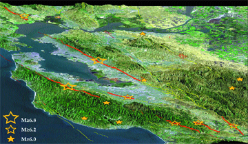
During the 75 years before the great 1906 earthquake on the San Andreas Fault,
which killed approximately 3,500 people, the San Francisco area suffered at
least 14 shocks greater than magnitude 6.0 on all its major faults, including
two events greater than magnitude 6.8. During the succeeding 75 years, there
was only one shock larger than magnitude 6.0. The release of stress building
up to the larger earthquake could shed light for seismologists trying to develop
earthquake patterns for local regions, as Ross Stein and colleagues reported
in Nature in 1999. Courtesy of R. S. Stein, Nature, 402, pp. 605-609,
1999.
The plate tectonics revolution of the mid-20th century led to the realization
that most of the planet’s large earthquakes occur along boundaries between
plates. The motion of the plates, driven by convection in the mantle, provides
the engine that drives the earthquake cycle. This understanding led to the “seismic
gap theory”: If motion at plate boundaries is accommodated by earthquakes,
then future large earthquakes can be expected along plate boundary segments
that are conspicuously quiet. Although the details of this theory have been
debated, the idea has apparently been vindicated as scientists have teased out
the earthquake histories of large plate boundary faults (see sidebar in Geotimes
print edition).
Seismic gap theory does not, however, lead immediately to prediction. Large
earthquakes on a given segment of the San Andreas Fault might recur, say, every
150 years on average, but if, as geologic data suggest, individual pairs of
earthquakes are anywhere from 100 to 200 years apart, prediction is clearly
hopeless. Indeed, scientists’ efforts through the late-20th century focused
on the business of long-term earthquake hazard assessment rather than prediction.
Hazard assessments use probabilities to highlight those zones where earthquakes
are likely to occur in a given time period, based on past activity. Such efforts
have been implemented with increasing sophistication in recent years, on a national
level by the U.S. Geological Survey and in California by a collaboration with
the California Geological Survey.
In parallel with these efforts to predict long-term hazards, some scientific
studies have shed further light on the details of the earthquake cycle. The
best promise for prediction lies in intermediate-term prediction: identification
of regions or faults where earthquakes are likely to occur within a few months,
years or, at most, decades.
Path to prediction
One promising line of research is finding that large earthquakes recur especially
regularly along some plate boundary segments, as illustrated by the Parkfield
prediction experiment. Although the 2004 temblor was late, its location and
magnitude were precisely what scientists had said it would be (see Geotimes
Web Extra, Sept. 28, 2004). The value of the prediction in this case was
not so much its warning to the general public but rather its impetus to scientists
to install sophisticated monitoring equipment to catch the earthquake “red-handed.”
Monitoring has expanded recently with the San Andreas Observatory at Depth experiment,
which is drilling into the heart of the active fault. Among the objectives is
to better understand the small earthquakes that recur on the fault almost like
clockwork.
In other regions, for example parts of Japan and perhaps the Hayward Fault in
San Francisco, the long-term regularity of earthquakes might allow scientists
to make meaningful predictions of potentially damaging earthquakes that are
likely to occur within the next few decades. Intermediate-term predictions would
be of significant value in regions such as San Francisco, as they would identify
regions where hazard mitigation efforts (for example, retrofitting of vulnerable
structures) should be focused. One might also imagine future intermediate-term
prediction experiments designed to capture expected large earthquakes.
Another area of research, which is both intriguing and controversial, looks
at evidence that earthquake activity over a given region can signal the approach
of a large earthquake. Some studies suggest that an impending large earthquake
is heralded by an increase in moderate earthquakes in the region surrounding
the fault, over a timescale of years to at most a couple of decades.
One conceptual view of this phenomenon is that the rate of moderate earthquakes
is suppressed after a large earthquake and returns to “normal” prior
to the next large earthquake. A different view is that the rate of moderate
earthquakes increases as the crust is strained around an impending rupture,
just as a flexed pencil might start to crack around the area that will eventually
break. Seismologists describe such a phenomenon as “accelerating moment
release” — an increase in the rate of energy released by earthquakes.
The accelerating moment release concept is not new, as prediction schemes have
been developed around this idea since the 1980s. However, since the 1990s, scientists
have developed an increasingly sophisticated theoretical and computational framework
to further explore the concept. In particular, we are now able to use computer
programs to predict not only how one earthquake will change the stress in the
neighboring regions of the crust, but also how an impending earthquake will
affect the crust.
To date, regions of accelerating moment release have been identified after large
earthquakes have occurred. Knowing the time and place of a large earthquake
allows scientists to look back and identify the pattern. The trick, of course,
is to predict earthquakes before they happen. This requires analysis of ongoing
earthquake patterns and identification of regions where the rate of earthquakes
is increasing.
Unfortunately, an increasing rate of earthquakes does not always signal an impending
large event. For this and other reasons, such investigations generally remain
in the realm of research science — not yet mature enough to provide the
basis for earthquake prediction. Still, a few researchers have been so bold
as to identify patterns before the fact and suggest that a large earthquake
might be imminent.
In recent years, for example, a group of scientists at the University of California,
Los Angeles, led by Vladimir Keilis-Borok made headlines with a new twist on
the method. Looking back at previous large earthquakes in several regions, Keilis-Borok’s
team identified a pair of patterns that they considered to jointly represent
a reliable precursor. Increasing moment release was one of the patterns; the
other was the appearance of a cluster of moderate earthquakes stretching over
a specified fault length and within a specified time span. When both of these
criteria are met, a prediction is issued for the region around the cluster,
lasting for nine months.
Keilis-Borok’s group circulated initial predictions privately among colleagues.
Although they have not published full results, two predictions appear to have
been fulfilled by large earthquakes in northern Japan and central California
in late 2003. Several subsequent predictions, however, including one for a large
earthquake in southern California in 2004, garnered substantial attention from
the media as well as the scientific community, but proved to be failures (see
Geotimes Web Extra, Sept. 7, 2004). No prediction
had been made by any researchers prior to the devastating Sumatra earthquake
of late 2004.
Future chatter
The highly publicized recent failure of the Keilis-Borok prediction and the
qualified (and belated) success of the Parkfield prediction perhaps illustrate
where seismologists stand in our quest for earthquake prediction: We are quite
good at identifying where large earthquakes are likely to occur on time scales
of several decades to centuries, but still unable to identify regions where
earthquakes will happen tomorrow, next week, or even within the next few years.
For this to change, scientists would have to identify a precursor that reliably
signals an impending large earthquake.
An intriguing new candidate did emerge at the close of 2004, when Robert Nadeau
and David Dolenc of the University of California, Berkeley, identified “tremors”
— a sort of seismological chatter — on the San Andreas fault near
Parkfield, below the part of the fault where earthquakes occur. Bursts of tremors
may portend future earthquakes, perhaps the signature of fluid migration in
the deep crust.
It is too early to know where these new signals might lead us, but the search
for the Holy Grail continues.
 |
Geotimes Home | AGI Home | Information Services | Geoscience Education | Public Policy | Programs | Publications | Careers |