
 Antarctica
truly is “the polar continent,” as it has resided over or near the South
Pole since Gondwanan supercontinent times about 350 million years ago.
Antarctica
truly is “the polar continent,” as it has resided over or near the South
Pole since Gondwanan supercontinent times about 350 million years ago. Climate connection
Today, the Southern Ocean surrounding Antarctica is the world’s only system
in which mixing occurs between water masses from all ocean basins. The Southern
Ocean is also the most biologically productive on Earth and plays key roles
in global budgets of carbon and nutrients and the exchange of carbon dioxide
between the atmosphere and the ocean via large-scale mixing processes.
Antarctica has several important sites where cold water sinks and acts as part
of the the driving wheels of the global ocean conveyor belt, which helps moderate
the climate of the high latitudes. The ice sheet exerts a direct influence on
the Southern Ocean, in part, through its influence on temperature and the strong,
gravity-driven winds that blow down the ice sheet and out over the coastal ocean.
These winds influence sea-ice formation and ocean mixing, which in turn influence
atmospheric and ocean circulation processes.
Thus, variability in Antarctic temperatures and the extent of glacial and sea
ice affects climate systems throughout the globe. Consequently, many researchers
believe it is critical to understand how the ice sheet will react to current
and future global warming, as some of the predicted scenarios by the International
Panel on Climate Change indicate that within a few centuries, greenhouse gas
concentrations, most notably carbon dioxide, could be higher than when the ice
sheets formed on Antarctica more than 30 million years ago.
An urgent task for numerical ice-sheet modeling is thus to assess the vulnerability
of the major modern ice sheets to future climate changes. ANDRILL’s investigation
of past variations of the West and East Antarctic ice sheets, the two components
of the Antarctic Ice Sheet, will help validate these models and also tell us
directly what ice-sheet responses to expect for given types and amounts of climate
change.
Previous large-scale modeling of the paleo-Antarctic Ice Sheet has concentrated
on the basic response of the East Antarctic Ice Sheet to changes in surface
snowfall and additions or losses of ice volume in the Cenozoic (past 65 million
years). The modeling suggests relatively minor recession of the terrestrial
East Antarctic Ice Sheet, with greater likely vulnerability of the marine-based
West Antarctic Ice Sheet. The potential for drastic West Antarctic Ice Sheet
retreat is not well understood because accurate modeling requires a challenging
combination of understanding different flow regimes — ranging from floating
ice to ice streaming — and understanding how the ice sheet moves on a layer
of water and deforming sediments.
Geological drill cores from the Antarctic margin provide direct evidence of
the past extent and variation in size of the Antarctic Ice Sheet and associated
oceanic and sea-ice processes. Scientists can compare data from these cores
to what is known from elsewhere about major events that affected the world during
the Cenozoic, such as ocean circulation changes, warming and cooling trends,
and sea-level changes. It thus becomes possible to evaluate the connection between
the changes in Antarctica and those in the rest of the world.
Data from ANDRILL will facilitate high-resolution ice-sheet and sediment models,
driven by larger-scale climate and continental ice-sheet models, and apply them
to the region. And detailed comparisons with the core data will enable validation
of the models and a unique opportunity to improve understanding of the interactions
among sea level, climate, sediment accumulation and changes in the ice sheet
— all filling an urgent need to better predict the vulnerability of West
Antarctic Ice Sheet to climate change.
The project’s core
 ANDRILL
is an international program including about 170 scientists from the United States,
New Zealand, Italy and Germany. The program has upgraded a drilling technique
adopted from previous drilling efforts, in which mining drill rigs were modified
for drilling sea ice. With a core recovery rate greater than 95 percent in the
types of materials encountered on the Antarctic continental shelf, this drilling
technology performs significantly better in Antarctic locations than other techniques
used by the Ocean Drilling Program farther offshore on the continental slope
and other locations.
ANDRILL
is an international program including about 170 scientists from the United States,
New Zealand, Italy and Germany. The program has upgraded a drilling technique
adopted from previous drilling efforts, in which mining drill rigs were modified
for drilling sea ice. With a core recovery rate greater than 95 percent in the
types of materials encountered on the Antarctic continental shelf, this drilling
technology performs significantly better in Antarctic locations than other techniques
used by the Ocean Drilling Program farther offshore on the continental slope
and other locations.
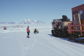
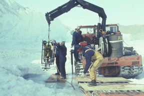
Researchers deploy a remotely operated
vehicle (ROV) through sea ice in the southwestern Ross Sea to investigate the
chemistry of the chilly waters. Image courtesy of Ross Powell.
ANDRILL’s new drilling rig successfully passed a recent drill
test in New Zealand after being customized to work from both sea ice and ice
shelves in Antarctica. The rig can lower 2,000 meters of drill string through
holes in the ice. For ice shelves, a custom-designed hot water drilling system
first melts an access hole through the ice and then the geological drill string
is lowered through it. This technology enables the collection of paleo-ice-sheet
and paleoclimate records from areas that otherwise are inaccessible.
Two projects within ANDRILL aim to recover records from different geological
time periods and thus address slightly different scientific questions. The McMurdo
Ice Shelf Project will begin drilling this October and will last approximately
two months. The Southern McMurdo Sound Project will start one year later, and
both projects are located near the U.S.-operated McMurdo Station and New Zealand-operated
Scott Base.
The McMurdo Ice Shelf Project will look at past responses of the floating Ross
Ice Shelf and grounded West Antarctic Ice Sheet to a range of climate forcings
over various timescales, as environments have changed with the growth or decay
of the ice sheet over the past 5 to 10 million years. To reach this goal, ANDRILL
will drill into a 1,200-meter-thick body of Pliocene-Pleistocene glacial, marine
and volcanic sediments that are rich in remains of fossilized marine life. The
sediments have accumulated in the Windless Bight region within a trough around
the still-active volcanoes forming Ross Island. The trough in Earth’s oceanic
crust around the island has formed over the past several million years as the
volcanoes grew in size and locally weighed down the crust.
The project will recover a single 1,000-meter drill core from the trough’s
axis in approximately 900 meters of water. Sediments recovered from this core
will be used to determine when the site was open water, or when it was covered
by sea ice, the Ross Ice Shelf or the West Antarctic Ice Sheet. At present,
scientists have little direct evidence of changes through time for this part
of the Antarctic Ice Sheet, which some believe is potentially quite sensitive
to climatic and sea-level changes.
In contrast, the Southern McMurdo Sound Project is targeting middle Miocene
to Pliocene deposits with some thinner younger deposits (approximately 17 million
years ago to present), which accumulated in a sinking tectonic basin generated
by faulting on the margin of the Victoria Land Basin in the western Ross Sea.
The project is primarily trying to establish a robust history of growth and
decay of the East Antarctic Ice Sheet and associated sea-ice changes during
the Neogene from about 17 million years ago up to about 2 million years ago.
Currently, scientists have windows of time in which they know what has happened
with this part of the Antarctic Ice Sheet, from the preserved sediments recovered
from previous drilling efforts. The new drilling will hopefully fill some of
the critical time gaps when the history of the ice sheet is not well-defined
or known at all. The project may also shed more light on the debates about how
active the East Antarctic Ice Sheet has been in the past. Understanding such
past behavior can help scientists understand how the Antarctic Ice Sheet may
behave during current and future global warming.
Only the beginning
In addition to ANDRILL, which the United States sees as a major contribution
to the International Polar Year (2007 to 2008), the U.S. geoscience community
recognizes that other data are important to geoscientific research on the geological
history of Antarctica. A number of geoscience initiatives oriented toward paleoclimatic
problems have evolved from recent NSF workshops. One such initiative, the SHALDRIL
(SHALlow DRILling) project, aims at ship-based coring along the Antarctic continental
margin. It will provide access to sedimentary records lying beneath the sea-ice
zone, between where ANDRILL is looking and the continental slope where more
traditional ship-based drilling platforms can be used.
Another project still in its planning phase is called FASTDRILL (FAST ice sheet
DRILLing), which is aimed at developing a mobile drilling system capable of
rapidly drilling local- to continental-scale arrays of deep boreholes through
the entire 3- to 4-kilometer-thick Antarctic ice sheet. This project will allow
unprecedented access to the glacial and subglacial environments that are of
growing multidisciplinary interest to geologists, glaciologists, biologists
and paleoclimatologists. This effort will potentially allow access to subglacial
lake environments to investigate life in deep ice and subglacial environments,
as well as access to paleoclimate records that are locked in lake sediments.
The latter would be the first deep-time paleoclimate records from well within
the continental interior of Antarctica.
Recent advances in remote sensing, autonomous and remotely operated vehicles
(AUVs and ROVs), and new geochemical and biogeochemical analytical techniques
are also providing a wealth of new data and opportunities for important discoveries.
Several new U.S. and international field programs using these new technologies
are either currently under way or being planned. These data-gathering missions
cover the full range of Antarctic environments, from the continental interiors
to the near-shore/ice-shelf zone, continental-slope/sea-ice zone, and the more
distal Southern Ocean.
Although Antarctica is often forgotten or ignored by laypeople and politicians
alike, due to its position as the world’s only polar continent tucked away
at the bottom of the world, its massive size (about 1.5 times as large as the
United States, including Alaska) and unique characteristics make it a major
player in climatic and geological research. The future of this frozen mass of
water has important societal ramifications that justify the need to drill back
in time in Antarctica, to gain a clearer understanding of how the ice sheet
is capable of behaving.
|
Breaking up (ice) is hard to do A panel of experts for the National Academies’ National Research
Council (NRC) is evaluating whether or not the U.S. Coast Guard’s
fleet of polar icebreaking ships needs a makeover. For the short term,
at least one of the ships will need to be revamped, or the U.S. Coast
Guard will have to build a new one, according to the panel. |
 |
Geotimes Home | AGI Home | Information Services | Geoscience Education | Public Policy | Programs | Publications | Careers |