
|
 Subscribe

TRENDS & INNOVATIONS
Put to the Nuclear Test: Seismology and the International Monitoring System
IMS helps with tsunami warnings
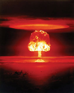 |
| Above: Nuclear explosions, such as the one above, can be detected by seismometers and other tools in the International Monitoring System (IMS). Photograph is courtesy of the U.S. Department of Energy.
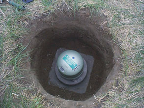
Below: Seismometers are a key piece of the IMS, a network designed to support the Comprehensive Nuclear Test Ban Treaty. Seismometers detect nuclear explosions like they detect earthquakes. Photograph is courtesy of Washington University. |
 |
When North Korea detonated what it claimed was a nuclear device on Oct. 9, 2006, seismologists were paying close attention. Seismology has had a link to nuclear weapons ever since seismic waves were recorded from Trinity, the world’s first nuclear explosion test, in 1945. The technology has since played a key role in efforts to monitor nuclear testing.
Although nuclear-capable nations have staged more than 2,000 weapons tests since Trinity, the North Korean event was of particular significance in the monitoring community. It was the first nuclear test conducted since the International Monitoring System (IMS), a global network of seismometers and other technologies established to support the Comprehensive Nuclear Test Ban Treaty (CTBT), has been up and running. As such, the North Korean test provided an opportunity for scientists to assess the IMS’s capabilities.
Unlike existing ratified treaties, which permit underground nuclear tests of 150 kilotons or less, the CTBT bans nuclear tests of all sizes and in all environments. The United Nations adopted the CTBT in 1996, but the treaty is not yet in force because it first must be signed and ratified by the world’s 44 nuclear-capable nations. Currently, three of these nations — North Korea, India and Pakistan — have neither signed nor ratified the treaty, and seven nations have signed but not ratified it.
Among the latter group is the United States, which in 1996 was the first nation to sign the CTBT. The U.S. Senate voted against ratifying it in 1999, however, over concerns that the plan for verifying adherence to the treaty’s total ban was inadequate. In particular, critics argued that the IMS would be unable to detect small, clandestine nuclear tests.
But in 2002, a National Academy of Sciences panel released a report that concluded that the IMS could detect and identify nuclear explosions with yields as low as one to two kilotons in any environment. “One kiloton is extraordinarily small for a nuclear test,” says Paul Richards, a seismologist at Columbia University’s Lamont-Doherty Earth Observatory, and a member of the panel.
So last year’s blast in North Korea was not only a test of that country’s nuclear device, but a test of the IMS’s actual capabilities. The IMS network comprises 170 seismic stations — the primary technology for detecting underground tests — and 151 total hydroacoustic, infrasound and radionuclide stations around the world that constantly monitor for evidence of nuclear explosions.
Currently, about three-fourths of the stations are in place and transmitting data to the International Data Center in Vienna, Austria. The center processes the data and sends them to official data centers in signatory nations for assessment. Although these data are not publicly released, seismic data similar to those collected through the IMS are often available to the general research community from stations operated by other organizations, such as the U.S. Geological Survey.
Seismic stations in both the IMS and other networks successfully detected the North Korean event, says Hans Hartse, a seismologist at Los Alamos National Laboratory in New Mexico. Data from the stations also allowed seismologists to estimate the location of the test and readily identify that it had the characteristics of an explosion rather than an earthquake. “Explosions tend not to produce as many S waves,” or shear waves, as earthquakes, Hartse explains.
Seismic data also provided an estimate of the blast’s yield: less than one kiloton, according to the U.S. Office of the Director of National Intelligence. “It is a very nice demonstration of how a relatively small event in a relatively under-instrumented part of the world can be quickly and confidently identified as an explosion based solely on seismic data,” says Keith Koper, a seismologist at St. Louis University. Analysis of IMS radionuclide data further identified the event as a nuclear rather than chemical explosion.
Overall, “the IMS functioned as expected,” says Thorne Lay, a seismologist at the University of California at Santa Cruz. “I think things worked very well.” Moreover, though researchers cannot reveal exactly how well the system worked due to security reasons, the network’s success at detecting and identifying a small nuclear test bolsters the conclusion of the National Academy report.
Still, many scientists recognize that, like any technology, the IMS can always be made better. Current research in seismology includes efforts to develop better regional models of Earth’s crust. Such models provide information about how Earth’s makeup in a particular region impacts the velocity and attenuation of seismic waves that move through it. This, in turn, helps seismologists estimate the location of a nuclear event more accurately. The work is directly relevant to the CTBT, which allows for inspection of only a 1,000-square-kilometer area around a suspected test site. Because of this inspection limit, “you want to be able to locate events with this level of precision,” Koper says. Improved regional models could also help seismologists better discriminate between different types of seismic events.
Researchers are also working to develop better automated methods for processing seismic signals. Tens of thousands of seismic events — including earthquakes, volcanic eruptions, mining blasts, and even traffic — occur every day, producing huge volumes of data. Automated processing is critical to the monitoring of these data, and helps to ensure that signals from any nuclear explosions are detected among the plethora of normal background seismic signals. “You can’t always expect a country to have a press conference” before conducting a nuclear test, Koper says, “and you can’t even expect that a country will test within its own territory.”
Jay Zucca, a seismologist at Lawrence Livermore National Laboratory in California, says he thinks the combination of improved models and high performance computing will “have a real big impact in the next five to six years in our ability to detect, locate and identify seismic events.”
Nonetheless, the current capabilities of the IMS, including its presumed 1- to 2-kiloton detection threshold, are nothing to sneeze at, according to Lay. Practically speaking, at some point, the size of a nuclear test becomes too small to benefit weapons development. “Systems can always improve,” Lay says, “but the current capabilities are very good and many scientists believe this is a low enough [detection] level that the CTBT can be implemented now and enforcement improved over time.”
|
Much to the frustration of many scientists, the rich collection of data gathered via the International Monitoring System (IMS) — a global network of seismometers and other technologies that support the Comprehensive Nuclear Test Ban Treaty (CTBT) — is generally not available for research. The reason is political: open release of the data is allowed only if all CTBT signatory countries agree to the idea. And currently, some countries don’t. The devastating Indian Ocean tsunami of Dec. 26, 2004, however, prompted CTBT officials to explore the idea of releasing IMS data for earthquake and tsunami monitoring. “It was a real big handicap in December 2004 that tsunami networks were not getting real-time data that could have helped them do their job,” says Paul Richards, a seismologist at Columbia University’s Lamont-Doherty Earth Observatory. By early 2005, the International Data Center in Austria, which collects the data, began forwarding seismic and hydroacoustic data to the Pacific Tsunami Warning Center in Hawaii and the Northwest Pacific Tsunami Information Center in Tokyo, Japan. Charles McCreery, director of the Pacific Tsunami Warning Center, says that the data, which fill gaps in global coverage and are more reliable than data from other sources, could help scientists process earthquakes more quickly and determine their magnitudes more accurately — both of which are important for a tsunami warning system. “We can see the benefits on the horizon,” he says. |

