
|
 Subscribe

FEATURE
The Impending Coastal Crisis
Nicholas K. Coch
With populations moving closer to coasts and development proceeding at breakneck pace, is disaster in store?
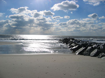
 U.S. Army Corps of Engineers |
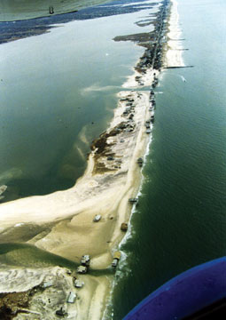
| The barrier islands off the coast of Long Island, N.Y., have been breached many times by storms, such as the 1992 and 1993 nor'easters, which breached the islands after decades of sand mismanagement. |
By mid-century, more than half of the U.S. population will live within a day’s drive of a coast or lakeshore. Once the realm of small villages and ocean-based economies, these areas are now heavily developed and populated with tourists and secondary homes. Many inhabitants appreciate the scenery, but assume shorelines never change. Geologists, however, see a different picture. Billions of years of geologic history have shown that coastal areas are the least constant features on the planet’s surface. Tropical storms (hurricanes) and extratropical storms (Pacific storms, nor’easters) devastate shorelines. In addition, the post-glacial rise in sea level enables storm surges to destroy coastal areas at higher and higher elevations each century. Fixed structures built on coasts with rising sea levels may be doomed.
Coastal Dynamics
Increasing coastal erosion has led to a clamor for engineering structures such as sea walls, groins and stone jetties at inlets to preserve shorelines. Seventy years of experience, however, have shown that while such structures may trap sand and build beaches locally, they cut off sand supply to other areas.
When waves arrive at an angle to the shoreline, they create a “littoral drift system” that moves great volumes of sand along a shoreline, in the same way that a stream transports sediment. The width of a beach at any location is a balance between the sand supplied by longshore drift and the sand that is removed in coastal storms. In short, beaches can maintain themselves — as long as the sand supply is not interrupted by man.
Stone or wooden groins built perpendicular to the shore will trap sand on one side but cause erosion on the other side. Rock jetties built to keep inlets open also cut off the sand supply, causing massive erosion on the beaches farther down the shoreline. The Atlantic coastline is filled with such structures, with eroding beaches behind them.
 Nicholas K. Coch - Queens College, City University of New York |
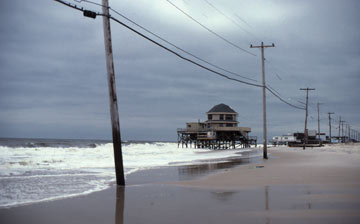
| Barrier islands naturally roll over. When the natural supply of sand is artificially halted, however, problems arise. In a winter storm in 1991, after decades of sand starvation, the sandy beach washed away beneath this house. |
Much of the Atlantic and Gulf coasts consists of barrier islands, which are basically elongated sandbars with bays on their landward sides, such as the Outer Banks of North Carolina. Development is most concentrated here, and the system is far from natural. In a natural system, barrier islands respond to storms and sea-level changes by a process called “barrier rollover.” In this centuries-long scenario, the front of the barrier island is cut back by waves and the sand is washed over the island to the back side. Thus, the island maintains its width, but moves landward with each storm. The landward bay shoreline will also move inland as sea level rises. Seen from space, the whole system looks the same after awhile, but all the elements are displaced landward. Where these barrier islands are developed and the natural sand supply is interrupted, however, the result of this process is that all the fixed structures on the barrier island, and on the bay shorelines as well, will eventually be destroyed unless we spend millions of dollars to replenish the beaches.
Long Island
Long Island’s south shore illustrates many of the problems facing the U.S. Atlantic and Gulf barrier island shorelines. Stretching almost 200 kilometers from Montauk Point at the tip of the island to New York City, it is one of the most heavily developed and populated hurricane-prone shorelines in America and has been greatly modified by development and engineering structures.
The defining moment for the Long Island coast was the 1938 Long Island-New England Hurricane. This Category-3 event caused severe beach and dune erosion, and breaching of the barrier islands in eastern Long Island formed 10 new tidal inlets across less than 25 kilometers of shoreline. Most of these inlets closed naturally within a year as sand drifted across their mouths. But the coastal devastation created pressure to build engineering structures to stabilize the remaining inlets for profitable navigation and to improve water quality and foster deposition on the beaches.
Immediately following the storm, Suffolk County stabilized Shinnecock Inlet in Hampton Bays with wooden bulkheads and jetties. Suffolk County and the state of New York then erected stone jetties at both Shinnecock and Moriches inlets from 1952 through 1954. The Army Corps of Engineers strengthened and improved these stone jetties in the 1990s and early 2000s. Some landowners in Southampton and elsewhere constructed stone structures to trap sand to widen the beaches in front of their homes. These engineering structures, especially the jetties at the inlets, had local benefits, but eventually removed sand from the littoral drift system that once nourished the beaches farther down the shoreline.
By the 1960s, erosion threatened shorefront structures and residents began to demand groins and bulkheads be built along the beaches to “control” erosion. The jetties built by the Army Corps to permanently stabilize major storm-cut inlets, along with older jetty systems, soon reduced the natural east to west sand movement. Sand accumulated at the eastern ends of inlet jetties and into the bays, carried by tidal currents. In contrast, the beaches on the western sides of each inlet were eroded at an accelerated rate because sufficient sand was not reaching those areas.
Although the Army Corps developed a beach nourishment program in 1958, Suffolk County was not interested in pursuing the program. Following a massive nor’easter in March 1962 that breached the barrier island in Westhampton Beach, they agreed to move forward with a modified storm protection plan. Unfortunately, the plan endorsed by Suffolk County and the state of New York did not include beach nourishment as the primary component, but rather relied on stone jetties (as many as 50) to deposit sand and locally stabilize the beach. This plan moved forward, primarily for local political reasons, despite the objections of the Army Corps of Engineers and others.
In 1964, after Suffolk County decided to build engineering structures to trap sand and maintain the beach westward to Moriches Inlet instead of the beach nourishment plan proposed by the Army Corps, in partnership with the county and state, the Army Corps began to build 21 groins extending east from Moriches Inlet through the hamlet of Westhampton and into the Village of Westhampton Beach. The groins were to be 146 meters long and constructed of large boulders. Commercial structures in Westhampton Beach, which along with larger homes in the area had been seriously damaged in nor’easters, were deemed vital to the local economy, and political pressure forced the Army Corps to build the groins in an east-west direction, the reverse of the original project plan. In addition, there were no plans to artificially fill the groin compartments, a measure that was recommended by the Corps. Because conventional groins cause sand deficits behind them, filling the groins with artificial fill upon construction helps sand move downshore, rather than being trapped in empty groins. The first 11 groins were built in 1964 and 1965 and four more were added in 1970. Construction was halted after Suffolk County refused to continue funding the project in 1972.
This plan would have worked if the project had been completed — but it was not. These two decisions — to build the groins in an east-west direction and not to fill the groin compartments — resulted in a coastal disaster when the county decided to stop the project at the 15th groin. Soon after, the beaches on the western side of the 15th groin began to erode at up to six meters per year, many times the historic rate of around a third of a meter per year. What little sand was moving west from Shinnecock Inlet was being trapped in the unfilled groin compartments at Westhampton Beach.
 Aram Terchunian |
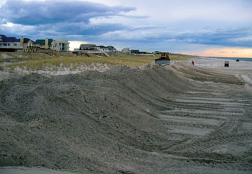
| Today, the beaches of West Hampton Dunes and nearby municipalities are replenished with sand to protect the development. |
Additionally, the Westhampton barrier island was “rolling over” at an accelerated rate due to the reduced sand supply, with erosion on the front side and sand overwashing onto the backside. Homes in the front were being lost to erosion and homes in the rear were being buried in overwash. Moving structures away from the beach was not an option because a road limited relocation away from the ocean.
These “storm protection” structures significantly reduced the natural sand flow westward along the south shore of Long Island, leading to extensive beach erosion in western Long Island, in Nassau County and in Brooklyn and Queens. Ironically, many of the “erosion control” measures that authorities built after these storms have actually weakened the beaches behind these structures, so that by the late 1960s, these beaches were much more vulnerable to hurricane damage than they were in 1938.
West Hampton Dunes
The situation came to a head in 1992 and 1993 when major nor’easters struck, breaching the barrier island system and resulting in the loss of 118 homes and another 60 undeveloped properties. The barrier island was breached in two places: Pikes Inlet and Little Pikes Inlet.
 Peter Dutton |
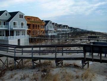
| In West Hampton Dunes, houses are built landward of the dunes to protect the shoreline. |
The Army Corps immediately undertook emergency measures to close Pikes Inlet, but initially, the smaller Little Pikes Inlet was not closed. This decision was fateful, as the breach that was initially narrow enough to jump across grew into a raging inlet more than 1,100 meters wide that swallowed 118 homes. By August 1993, Little Pikes Inlet was closed: Steel sheets were driven into the inlet bottom and hydraulic fill was added to close the breach and bring the surface level up to three meters above sea level.
Local residents who were outraged at losing their property banded together to incorporate themselves as a new village, West Hampton Dunes, which enabled them to finish litigation that had begun the 1970s against Suffolk County, the state of New York and the federal government. The residents successfully argued in federal court that building the groins from east to west, not filling the groin compartments and not finishing the project caused the erosion that deprived them of their homes and property.
An agreement between all parties was signed on Oct. 31, 1994. The agreement specified a number of remedial and maintenance plans, such as shortening the westernmost groins, artificially filling groins to help transfer sand westward, building artificial dunes and beach berms in front of homes and establishing conservation zones to keep the dunes in good shape. Today, West Hampton Dunes is a model coastal community: beautiful, well managed, storm resistant and environmentally conscious.
But is it a happy ending?
A coastal geologist may see a somewhat different picture, however. The “dunes” are really berms or ridges built up from hydraulic fill that was dumped and bulldozed into shape. Sand grains that are dumped in place by a bulldozer or dump truck are packed more loosely than those deposited by water and wind. Therefore, such bulldozed dunes have little resistance to these forces. In fact, a similar ridge system failed in South Carolina during Hurricane Hugo in 1989.
 Aram Terchunian |
| Rock jetties, groins and other reinforcements have been built at Westhampton Beach to try to secure the beaches, but these engineering structures have actually increased erosion at other parts of the island. |
Since restoration of the area was completed, there has been a marked increase in development. Modern West Hampton Dunes is far more densely populated than ever. However, instead of modest beach homes, numerous multimillion-dollar three-story houses line the road in close proximity. Some homes have as many as three sets of cooling units and propane tanks attached to their sides, and many have structures such as gazebos and walkways in front of them, which greatly increase the amount of potential storm debris.
A Category-3 hurricane can be expected to have a storm surge height of more than four meters with waves six to nine meters high. If a hurricane makes a landfall at high or spring tide, nothing built at West Hampton Dunes will survive.
What can we learn?
West Hampton Dunes illustrates the benefits and problems created by trying to manage our shorelines to limit the inevitability of coastal erosion. Coastal segments are an integrated system; reducing erosion at one place will cause further erosion at another. We cannot expect fixed structures to survive as the shoreline inevitably moves. Yet, we often do expect just that.
Coastal homeowners, “protected” by artificial sand berms and engineering structures, may think that they are secure. However, the picture is bleak: Sea level is rising, sea-surface temperatures are increasing and most tropical weather experts agree we have entered a multidecadal period of greater hurricane frequency. It has been more than 70 years since a major hurricane hit the coast of Long Island. But the last major hurricane affected parts of six states. Are we ready for that?

