Key: A= Agriculture, F= Wildfires, W= Water Supplies
Map courtesy of NOAA/NCEP
| Geotimes Home | Calendar | Classifieds | Advertise | Subscribe |
| Geotimes
Published by the American Geological Institute |
News
and Trends in the Geosciences
May 2000 |
The southern United States and several states in the Midwest will be in for another severe drought this summer, according to a projected spring forecast released by the National Weather Service.
Our data indicate drought conditions are probably going to get worse before they get better, said Secretary of Commerce William Daley at a March 8 press conference in Washington, D.C. The forthcoming drought may increase the risk of fires, limit drinking water supplies and induce severe lightning storms and tornadoes.
The areas in the worst shape for drought are the Appalachian regions and the southeastern United States, said USGS Director Charles Groat. Surface and underground water levels reflected poor snowfall this winter as the network of over 7,000 USGS stream gages measured record low flows.
The Department of Commerce aims to help industries such as agriculture, tourism and shipping by developing new seasonal prediction outlooks for droughts and floods. On average, droughts have damaged the economy by $6 billion a year, Daley said.
Still, different marketing strategies by businesses often do not help farmers hit with low soil moisture content, high temperatures and lack of water for irrigation. Last summers drought left 60 percent of the nations counties in a state of agricultural disaster, receiving aid mainly in the form of low interest loans, Secretary of Agriculture Dan Glickman said.
The National Drought Policy Commission released a report March 8 that stresses the importance of preparedness for droughts over the current policy of declaring disaster areas and distributing aid after they are damaged. The report includes crop insurance and improved risk management programs as ways to offset costs to farmers during drought years. It also recommends mitigation measures to conserve water: more efficient irrigation practices, livestock watering ponds and improved public education on droughts. Says NOAA Administrator D. James Baker: Forewarned is forearmed.
Alison Alcott
Geotimes
contributing writer
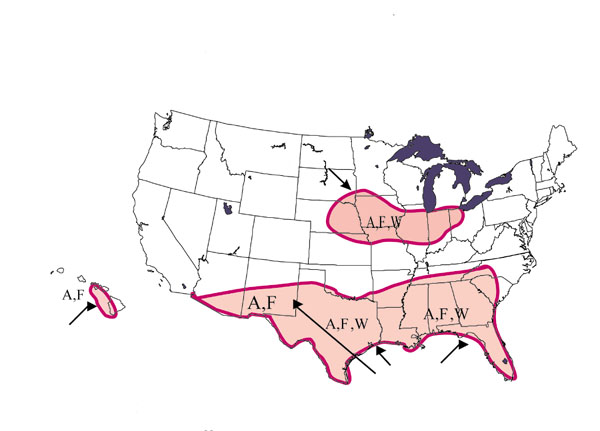
Spring
U.S. Drought Outlook: April-June 2000 Areas Most at Risk
Key: A= Agriculture, F= Wildfires, W= Water Supplies
Map courtesy of NOAA/NCEP
 |
Geotimes Home | AGI Home | Information Services | Geoscience Education | Public Policy | Programs | Publications | Careers |