Chasing Lava: A
Geologist’s Adventures at the Hawaiian Volcano Observatory
by Wendell A. Duffield. Mountain Press Publishing Company,
January 2003. ISBN 0 8784 2462 8. Paperback, $16.00.

Check out this month's On
the Web links, your connection to earth science friendly Web sites. The
popular Geomedia feature now available by topic.
Book Reviews:
Chasing Lava
Meteorites, Ice, and Antarctica
Maps:
Digital mapping for Washington state
|
Chasing Lava: A
Geologist’s Adventures at the Hawaiian Volcano Observatory
|
The above title is not the first question that comes to mind when you pick
up Wendell Duffield’s book Chasing Lava, but the answer is only one of
many interesting and entertaining tidbits to be found within this charming memoir
of the author’s three years (1969-1972) as a staff scientist at the U.S.
Geological Survey’s (USGS) Hawaiian Volcano Observatory (HVO).
In 1969, Neil Armstrong walked on the Moon. That year was also a time of turmoil
within the earth sciences, with the emergence of plate tectonics as an exciting
new paradigm. Many geologists will be familiar with the now-almost-clichéd
analogy between motions of Earth’s plates and the skins of convecting lava
ponds. This analogy was developed by Duffield (known as “Duff” to
his friends, someone you’ll be by the end of the book’s introduction)
through his observations of the active lava lake at Mauna Ulu in the early 1970s
(and described in an article in Geotimes, April 1972). This time period
included several eruptions of Kilauea Volcano in Hawaii and corresponding advances
in our understanding of Hawaiian volcanoes. Finally, it was the time during
which a self-described Lake Wobegon kid was transformed into a Hawaiian volcanologist.
MIT geologist Thomas A. Jaggar founded HVO in 1912. After the catastrophic 1902
eruption of Mt. Pelee in Martinique, which killed more than 28,000 people, Jaggar
recognized the need for a training ground for volcanologists. His motto for
the observatory — Ne plus haustae aut obrutae urbes (No more burned
or buried cities) — states his vision and frames Duffield’s book.
Photos of Jaggar, reproduced in tasteful sepia, provide inspiration both for
pursuit of ambitious goals and for standards of field attire (shirt and tie,
please). Our personal guide to Hawaii’s volcanoes, however, is of a more
humble nature: Mingo, the Duffields’ cat and, also perhaps, the personification
of the family `aumakua (Hawaiian protective deity). And Duff proves a
humorous articulator of all things Hawaiian and volcanic.
Chasing Lava consists of 24 chapters, most short but all beautifully illustrated
by color photographs and diagrams and by engaging grayscale drawings. Each chapter
title encapsulates the flavor of the book.
For example, “Are You on the Level?” recounts experiences of “leveling”
the volcano, that is, of measuring and remeasuring the relative elevation between
points to monitor deformation of the volcano’s surface. However, the title’s
play on words refers to the leveling team’s attempt to alleviate the boredom
of the job (and to counter disparaging comments from Park Service employees
about geologic dress codes) by creating and wearing team shirts emblazoned with
the words “O`ahu State Prison” in bold letters across the back.
The colorfully titled chapters “Water Beds and Magma Beds,” “Tree
Molds and Leg Molds,” “A Suffocating Experience” and “How
Fast Can You Run” introduce the reader to the hazards and resultant adrenaline
(and sometimes red-rock addiction) experienced by those who choose to spend
their time playing with molten lava.
The scientific content of Chasing Lava is not confined to Kilauea’s activity
in the early 1970s. The book provides a nice overview of hotspot volcanism,
the history of the HVO (and with it, the development of modern methods of volcano
monitoring) and the workings of a volcano observatory.
Also covered is the larger structure of Kilauea Volcano, from the movement of
landslide blocks of the Grand Staircase during an earthquake in 1975 to the
continuous southward motion of Kilauea’s South Flank first identified by
Duff, Don Swanson and Dick Fiske (all USGS employees at the time) through their
pioneering surveying efforts.
Interspersed with scientific overviews are quirky bits of HVO history and lore.
In “Swords into Plowshares, Spears into Pruning Hooks,” Duff intertwines
an introduction to the Koa`e fault system with a history of military trash in
the Ka`u Desert. Although I know several volcanologists who have collections
of military debris from desert surveys, I did not know that there were still
live shells to be found (and avoided!), or that the original HVO water tilt
meters were constructed from salvaged World War II artillery-shell casings.
More entertaining (and less politically correct from a 21st century vantage
point) are Duff’s accounts of field experiments pursued by spectacle-seeking
scientists (coupled with a “geologist’s inherent urge to throw rocks”).
First, there was the premature eruption attempt. The scientists tried to generate
eruptions from a “pistoning” lava lake by “seeding” it with
vats of water (one- and five-gallon containers) and, when those failed, a metal
container filled with explosives — to no avail.
Not having learned from that experience, the scientists continued to flaunt
Pele (the deity of Hawaii’s volcanoes) with an additional experiment. To
demonstrate a direct connection between a convecting lava lake within the Mauna
Ulu crater and a fissure source for lava just a few hundred yards away, the
scientists employed a half-ton of bastnäesite, a lanthanum-rich mineral
mined in southern California. As there is very little lanthanum in Hawaiian
basalt, the idea was that adding a large dose of lanthanum to a lava lake would
contaminate the lava sufficiently to provide a chemical fingerprint that could
be traced in time and space, potentially providing information on both lava
transfer and mixing rates. The result? Well, you can guess.
Finally, Chasing Lava includes stories of life on a tropical volcanic island.
From rainwater to groundwater to mix-ups in the plumbing of Volcano House (the
Sheraton hotel perched on the rim of Kilauea Caldera), Duff philosophizes about
the importance of water on the planet. On a more lighthearted note, he introduces
the reader to fruits both tropical and volcanic, including Pele’s fruit,
the `ohelo berry (in the author’s view, best sampled after fermentation).
And about the snake? I’ll leave that for you to find out as you read the
book.
 |
Meteorites, Ice, and Antarctica
|
Meteorites are concentrated on the ice in Antarctica! This thought,
which suddenly flashed “bright as a comic-strip light bulb” into Bill
Cassidy’s mind, marked the moment of origin of the U.S. program of collecting
Antarctic meteorites.
Cassidy was listening to a presentation by Makoto and Masako Shima, a husband
and wife team, at a meeting of the Meteoritical Society in Davos, Switzerland,
on the evening of Aug. 27, 1973. Makoto Shima described the chemical compositions
and rare gas contents of four meteorites of distinctly different types that
had been found by Japanese glaciologists in December 1969 on a small stretch
of ice in the Yamato Mountains in Antarctica. If the four fragments were not
pieces of a single fallen body, they had to belong to a concentration. But meteorite
concentrations were not known to exist anywhere in the world.
At that moment, Cassidy could not think of a mechanism to produce one, but the
Yamato discovery (which he learned later that evening actually consisted of
nine different meteorite species) was something so new and exciting that he
began then and there to compose a research proposal that he would submit to
the National Science Foundation (NSF). He planned to search for meteorites out
of the U.S. base at McMurdo Station, across the continent from the Yamato Mountains.
After years of proposal revisions, in 1976, Cassidy began his program, the Antarctic
Search for Meteorites (ANSMET) — the subject of his recent book, Meteorites,
Ice, and Antarctica.
Cassidy tells his story in three parts, with an appreciative foreword written
by the late Robert M. Walker, the founder of the McDonnell Center for Space
Science at Washington University in St. Louis. The dust jacket calls the book
a personal account, which describes it precisely. Written in the first person
and sometimes directly addressing the reader, it is partly an adventure story
and partly a nontechnical, but scrupulously accurate, science text that is strongly
flavored throughout with Cassidy’s whimsical views.
Early in the book, Cassidy describes the exhausting 22-hour flight in the noisy
interior of a C-141 cargo plane from California to Christchurch, New Zealand,
where scientists are outfitted with Antarctic gear before being shipped on to
McMurdo Station. When he arrived at McMurdo, he found that two Japanese scientists
had come earlier and already begun to hunt for meteorites. The administrator
at the NSF chalet declared there would be only one meteorite project that season
and asked the two teams to work together. They agreed, and Cassidy composed
a brief memorandum to the effect that they would conduct joint field searches
and share equally in the meteorites they collected, regardless of who actually
discovered them. The brief U.S.-Japanese agreement, which Cassidy composed that
evening in McMurdo, is included in the book as Appendix A.
This arrangement continued for three field seasons and Cassidy found it to be
advantageous in several ways. He learned much from the Japanese members, each
of whom had extensive experience in Antarctica. Furthermore, because NSF did
not supply snowmobiles for the first two seasons of meteorite searches (which
some at NSF saw as an intrusion into the traditional Antarctic programs), the
Japanese shipped snowmobiles of their own to McMurdo for their third season;
this incident embarrassed NSF into supplying vehicles to Cassidy’s team
for that and all later seasons.
Cassidy originally planned to return his meteorite samples to his home base,
the University of Pittsburgh, as do most principal investigators who work on
NSF grants. He hoped to build a curatorial center from which to send research
samples to laboratories around the world. But he found that larger moves were
afoot and he began to hear ominous sounds, “as of leviathans lumbering
about . . . in the flickering shadows at the edge of the clearing.”
Both NASA and the Smithsonian Institution, which curates the national meteorite
collection in Washington, D.C., were interested in the Antarctic meteorites.
In the negotiations that ensued, Cassidy relinquished his claims for keeping
the samples but won an understanding that the collecting program would remain,
at least for the time being, at the University of Pittsburgh.
The three agencies then reached an agreement whereby the NSF would fund and
provide logistical support for the fieldwork and technically retain ownership
of the meteorites collected. NASA would serve as the initial curator of the
Antarctic meteorites using laboratory procedures similar to but somewhat less
strict than those it had developed for the Apollo samples; NASA also would supply
sterile (Apollo surplus) paraphernalia to the field teams to avoid contamination
of these precious planetary materials during their collection from the most
sterile environment on Earth. The Smithsonian’s National Museum of Natural
History would be the final archival site of the annually growing collection.
Cassidy describes this three-agency agreement as unique in the U.S. government
and one that has proved advantageous to all parties.
In Part I, Cassidy reports an initial success for ANSMET when two meteorites
were found on the first day in the field; but no more were spotted for the next
six weeks. Luckily, a helicopter pilot offered them a ride to the Allan Hills,
where they struck a bonanza. This discovery assured the program a second season,
and ANSMET teams have gone to the ice annually since then (except for 1989 to
1990, when participation was cancelled because of abnormally bad weather and
a series of aircraft malfunctions).
As his teams grew larger, Cassidy chose meteorite specialists from several countries.
(This reviewer was fortunate enough to be a member in the third and sixth seasons).
Cassidy led the field parties himself from 1976 to 1993 and then yielded his
position to co-investigator Ralph P. Harvey, an experienced team member and
former graduate student, who currently is serving as the leader of ANSMET.
Early in Part II, Cassidy points out that as of 2003, ANSMET and teams from
Japan and Europe had collected approximately 30,000 meteorite fragments in Antarctica.
The great majority of them are stony meteorites of very ordinary types, but
among them are rare fragments of Mars, the Moon and previously unknown rock
types from asteroids. Cassidy devotes one chapter to martian and one to lunar
meteorites, recounting their controversial histories and explaining how they
were identified and how much they have added to our knowledge of their parent
bodies.
He also gives a remarkably informative account of the latest ideas on the origin
of the solar system from a primeval nebula — in which minute grains bearing
isotopic anomalies that formed in other stars were incorporated into meteorites.
He then outlines the classification of meteorites. This section presents a highly
technical subject in clear, nontechnical language that will be of interest not
only to general readers but also to scientists who know a lot about meteorite
classification but may not be completely up-to-date on the new varieties.
In Part III, titled “Has It Been Worthwhile?,” Cassidy evaluates the
Antarctic collection and its contributions to science. He argues that being
frozen into the ice sheet has delayed the severe weathering that destroys most
stony meteorites on other continents within a few tens of thousands of years.
As a result, Antarctica has yielded stony meteorites that fell to Earth from
recent times back to about 2 million years ago. This spectrum includes the unusually
large proportion of rare types of meteorites found there. Cassidy discusses
the dynamics of ice motion and possible modes of formation of stranding surfaces.
He also laments the paucity of research on this subject that should help to
trace the history of the ice sheet through various periods of climate change.
He devotes his final chapter to thoughts about research activities for the future.
Cassidy aims to write for the “intellectually curious general reader.”
With this book he has succeeded spectacularly. It is an absorbing account of
a project that started from a sudden inspiration in 1973 and has evolved into
a scientific program of international importance. Nobody else could have told
this story, which is beautifully written and spiced with a warm, low-key sense
of humor. This is a most welcome addition to the mass of literature on Antarctica
and on meteorites, and it will be enjoyed by general readers and scientists
of all ages.
 Washington
is one of the few states that has completed 1:100,000-scale digital geological
mapping statewide. Most states do not have any complete coverage at any scale
other than 1:500,000 state geologic maps. The Washington mapping has led to
the creation of a georeferenced geologic database that enables users to make
rapid and accurate assessments of the geology of an area for a multitude of
purposes, including land management and earthquake mitigation.
Washington
is one of the few states that has completed 1:100,000-scale digital geological
mapping statewide. Most states do not have any complete coverage at any scale
other than 1:500,000 state geologic maps. The Washington mapping has led to
the creation of a georeferenced geologic database that enables users to make
rapid and accurate assessments of the geology of an area for a multitude of
purposes, including land management and earthquake mitigation.
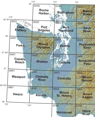
Shown here are several of the 1-degree by 2- degree quadrangles of Washington
state, identified by quadrangle name; numbers are quadrangle identifiers within
the digital product. This recent digital mapping has enabled users to make rapid
assessments of geology in the state. Courtesy of Washington State DNR.
As an intermediate step to creating new geologic maps of Washington at 1:250,000
scale, in 1983 the Washington State Department of Natural Resources (DNR), Division
of Geology and Earth Resources — the state’s geologic survey —
decided to first compile existing geologic mapping into 1- degree by 2-degree
quadrangles at 1:100,000 scale. The compiled geology for all of the 51 quadrangles
that cover Washington has since become the basis for the state’s georeferenced
digital geologic database.
In 1994, the survey began the conversion of paper maps to digital 1:100,000-scale
coverage under a $15,000 contract with the Washington State Department of Ecology
to digitize two quadrangles near Hanford Nuclear Reservation in south-central
Washington. Subsequent contracts (1996-2000) through the STATEMAP component
of the National Cooperative Geologic Mapping Program, administered by the U.S.
Geological Survey (USGS), called for the completion and delivery of digital
geology data for the remaining 49 quadrangles. This financial support radically
improved how quickly the survey generated the digital geologic maps. The last
of the geologic coverage was completed in 2003. The digital data can now be
downloaded online.
The 1:100,000-scale mapping has been useful far beyond its original purpose
as a step in compiling the 1:250,000-scale map. The derived digital coverage
has become the starting point for a number of other projects. It is the basis
for the survey’s statewide earthquake hazard mitigation maps, which provide
needed information on liquefaction susceptibility and National Earthquake Hazard
Reduction Program soil types to counties and cities for growth-management decisions.
The survey also uses the data to produce rock aggregate resource inventories
for growth-management planning.
The database is useful to county planning departments for land-use planning,
the U.S. Forest Service Fish and Wildlife, and DNR for watershed and ecological
planning, as well as to USGS, the U.S. Bureau of Land Management, exploration
geologists, geological engineering consultants, hydrology consultants, air photo
consultants, cellular communication businesses and universities.
The georeferenced database is especially beneficial in geologically complex
or legally contentious areas. In those regions, significant resources can be
expended on costly legal entanglements if planners do not make decisions with
careful consideration of the area’s geology.
References:
Schuster, J. E., 1983, Division to start work on new state geologic map, Washington
Geologic Newsletter, 11(4):6-7.
Schuster, J. E., 1996, Progress on the state geologic map, Washington Geology,
24(4):20-21.
 |
Geotimes Home | AGI Home | Information Services | Geoscience Education | Public Policy | Programs | Publications | Careers |