
For decades, geologists have known that land in Yellowstone National Park has been rising and falling due to activity in a massive magma chamber that lurks beneath the park. New satellite images are providing a testament to just how extensive those land changes are, and what processes are controlling them.
 The heart of Yellowstone lies inside a 45-kilometer-wide by 75-kilometer-long
crater, or caldera — a remnant of an explosive volcanic eruption about
640,000 years ago that vented more than 2,500 cubic kilometers of magma (nearly
6,000 times greater than the volume erupted in the 1980 eruption of Mount St.
Helens). Within this caldera, two deep magma domes periodically have been rising
and falling since long before the last eruption in Yellowstone 70,000 years
ago, says Charles Wicks of the U.S. Geological Survey in Menlo Park, Calif.
Alongside these land changes has been the famed hydrothermal activity throughout
the park, as well as many small earthquakes.
The heart of Yellowstone lies inside a 45-kilometer-wide by 75-kilometer-long
crater, or caldera — a remnant of an explosive volcanic eruption about
640,000 years ago that vented more than 2,500 cubic kilometers of magma (nearly
6,000 times greater than the volume erupted in the 1980 eruption of Mount St.
Helens). Within this caldera, two deep magma domes periodically have been rising
and falling since long before the last eruption in Yellowstone 70,000 years
ago, says Charles Wicks of the U.S. Geological Survey in Menlo Park, Calif.
Alongside these land changes has been the famed hydrothermal activity throughout
the park, as well as many small earthquakes.
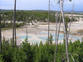
New research is suggesting that magma located below the Norris Geyser Basin in Yellowstone National Park periodically rises close to the surface, heating the geothermal field, before diving back down. Photo is by Lisa M. Pinsker.
From 1997 to 2003, researchers observed a period of uplift and subsidence in the crater using GPS measurements, and Wicks and his colleagues were hoping to learn more. So, they turned to Synthetic Aperture Radar Interferometry (InSAR) from a European Space Agency satellite to get a different view of the moving magma.
InSAR mathematically combines different radar images over time to create digital elevation models, which can reveal changes that are otherwise undetectable, says Paul Segall, a geophysicist at Stanford University in Palo Alto, Calif., who is not part of Wicks’ team. What the team found was “startling,” Segall says.
As published in the March 2 Nature, the team not only found uplift and subsidence occurring at the domes inside the caldera as researchers had observed in the past, but also discovered a notable 13-centimeter uplift under the north rim of the caldera. “This uplift at the margin of the caldera could be interpreted as showing migration of magma,” Segall says.
Indeed, Wicks and colleagues suggest that the uplift on the rim of the caldera is probably associated with the movement of magma up and out of the caldera through a “valve-like system” at the north rim, Wicks says. Like with a faucet, where water is always in the pipes, magma is always present beneath Yellowstone, he says, and the valve controls when it moves. The “slug-like blobs” of magma crawl beneath the caldera and through the domes, inflating and deflating the land as the magma comes and goes.
 The magma then squeezes through a small pathway at the north rim, which is
controlled by tectonic activity, Wicks says. When tectonic activity effectively
slows movement in the “faucet” to a trickle, magma builds up in the
rim and inflates it, he says. When the valve opens again, magma passes through,
spreading out beneath the geothermal Norris Geyser Basin. Below Norris, Wicks
says, as magma spreads out, it heats up the field before diving back down deep
into Earth.
The magma then squeezes through a small pathway at the north rim, which is
controlled by tectonic activity, Wicks says. When tectonic activity effectively
slows movement in the “faucet” to a trickle, magma builds up in the
rim and inflates it, he says. When the valve opens again, magma passes through,
spreading out beneath the geothermal Norris Geyser Basin. Below Norris, Wicks
says, as magma spreads out, it heats up the field before diving back down deep
into Earth.
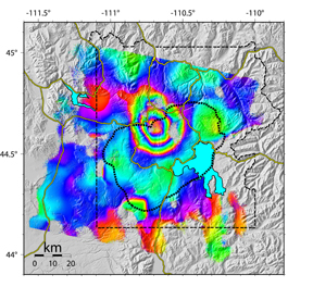
Scientists compiled this image of ground deformation in Yellowstone caldera using satellite images taken from 1996 through 2000. The image shows 12.5 centimeters (5 inches) of uplift centered within the northern end of Yellowstone caldera (black dotted line), about 10 kilometers south of Norris Geyser Basin. Each full spectrum of color (from red to purple) represents about 28 millimeters (1 inch) of uplift. Image is courtesy of Charles Wicks.
Magma movement has long been hypothesized as the cause of the inflation and deflation in Yellowstone, as well as other volcanic areas such as the Long Valley Caldera in California and the Campi Flegrei near Naples, Italy (see Geotimes, April 2006). Another hypothesis, however, has been that the movement of hydrothermal fluids drives the land changes.
Wicks’ team’s suggestion that magma movement is causing the deformation “definitely is a possibility,” Segall says. The lack of certain geochemical signals, such as a lack of chloride in the groundwater, and the uplift across the caldera margin “would argue against a hydrothermal hypothesis.” Still, he says that he remains skeptical — “what is truly going on below the surface is still quite uncertain.”
Wicks says that his team is pretty confident that magma movement is causing the land changes, but agrees that more integration of seismic data, gravity measurements, geochemical tests and other data can help determine changes at depth. There’s a lot still to be done here, Segall says, and “we’re really just scratching the surface of what we can hope to learn about volcanoes through InSAR.”
In the end, however, studying how magma moves below Yellowstone will enable researchers to learn more about the “normal” range of land changes in the volcanic system, Wicks says. Now, if researchers observe an “abnormal” land change, they may have forewarning of seismic activity and a possible eruption. Yellowstone will erupt again, he says; it is just a matter of when and how.
Megan Sever
Links:
"Italy's hidden hazard," Geotimes, April 2006
Print
Exclusive
"Truth, fiction and everything
in between at Yellowstone," Geotimes, June 2005
 |
Geotimes Home | AGI Home | Information Services | Geoscience Education | Public Policy | Programs | Publications | Careers |