geotimesheader
Feature
REMOTE
SENSING FOR ACID MINE SITES
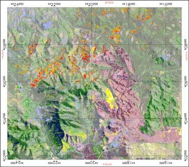 |
What: Vegetation
classification image derived from Compact Airborne Spectrographic Imager
(CASI) airborne sensor data
Where: Tintic
mining district
Resolution:
4 meters Ground Resolved Distance (GSD)
From: G.
A. Borstad & Associates for the NASA Earth Observations Commercial
Applications Program
|
Vegetation can mask the distribution of mineralogical anomalies. Combining
vegetation classification with geologic information can produce a powerful
tool for seeing mineralogical distributions around mine sites. Hyperspectral
data can help classify vegetation.
Deciduous vegetation is shown in colors extending from red to golden
yellow, with evergreens shown in medium to dark green. Bare ground, shown
in pale yellow, often matches with mines and mine wastes.
Purple areas are those affected by a July 1999 brushfire. Some mine
sites were better exposed after the fire, but the ash and soot were so
uniform and thick that the fire left few new rock outcrops exposed.
To evaluate how effective hyperspectral data are for measuring, mapping
and monitoring abandoned mine wastes and their effects, the Environmental
Protection Agency (EPA) Region 8 teamed up with other federal and state
agencies and with industry to study hyperspectral data for five mine sites
in Utah. Called the 1998-2000 EPA-Interagency-Industry Abandoned Mine Lands
Watershed Hyperspectral Analysis Project, the partnership generated hyperspectral
maps for 1.5 million acres and 27 watersheds in the Leeds, Silver Reef,
Marysvale, Tushar Mountains, Oquirrh Mountains, Park City and Tintic mining
districts in Utah. The EPA Region 8 contracted with NASAs Jet Propulsion
Laboratory to gather data from AVIRIS. The USGS SpecLab in Denver processed
the AVIRIS data, conducted field calibration studies and provided a final
evaluation to the EPA.
The EPA Region 8 also challenged the remote sensing industry to demonstrate
its commercial capabilities pro bono. Two commercial airborne hyperspectral
vendors joined the study: Earth Search Science Inc., with its Probe I hyperspectral
system; and a team lead by Borstad & Associates, Spectral International
and Peters Geosciences utilizing the CASI /SFSI (Compact Airborne Spectrographic
Imager/Short Wave Infrared Full Spectrum Imager) hyperspectral systems,
in part under a grant from NASAs John C. Stennis Space Center. Other study
participants included Asarco Inc., Autometrics Inc., the Colorado School
of Mines, Kennecott Exploration Co., Newmont Mining Corp. and Tintic Utah
Metals.
For more about the study results and imagery, visit www.denver.issiinc.com/imspec.
Back to main article.
