 |
|
REMOTE
SENSING FOR
ACID MINE SITES By Frederick B. Henderson III |
|
|
| Geotimes Home | Calendar | Classifieds | Subscribe | Advertise |
| Geotimes
Published by the American Geological Institute |
November
2000
Newsmagazine of the Earth Sciences |
|
|
REMOTE
SENSING FOR
ACID MINE SITES By Frederick B. Henderson III |
|
|
In 1987, NASAs Jet Propulsion Laboratory introduced AVIRIS, the Airborne Visible Infrared Imaging Spectrometer. It was the first hyperspectral imaging system, flying on an ER-2 plane up to 20 kilometers above Earth and measuring the surface in visual to short-wave infrared wavelengths ranging from 400 to 2,500 nanometers. AVIRIS produces a complete spectrum that represents the composition of Earths surface.
NASA and private companies are now developing
satellite systems that can remotely see Earths surface at increasingly
high resolutions. OrbImages Orbview-4 can provide hyperspectral data at
resolutions ranging between eight and 24 meters. Earth Search Science Inc.s
NEMO
satellite will provide similar data at a 30-meter resolution. The Canadian
Radarsat Program will soon offer multispectral radar reading down to three
meters. The U.S. government has loosened security restrictions on high
spatial and spectral resolutions of satellites, making way for companies
to develop these new satellite systems for monitoring Earth: Space Imagings
recently launched IKONOS 1 satellite, for example, along with satellites
that EarthWatch and OrbImage will launch, will view Earth at a one-meter
spatial resolution.
Environmental remote sensing began when NOAA
launched meteorological satellites in the 1960s, and continued with land
and ocean satellites such as Landsat, SPOT.ERS, JERS
and Radarsat. These satellites can map and monitor large-scale environmental
problems, but their resolutions are too low for detecting the small-scale
problems.
With the advent of commercial, high-resolution satellites, coupled with hyperspectral data, remote sensing can monitor industrial and urban pollution down to one meter and is proving a tool for identifying individual materials.
More researchers are recognizing that mapping with high-resolution spectral images of Earths surface is also useful for studying and monitoring acid mine wastes and their impacts on surrounding watersheds. Hyperspectral remote sensing allows for high-resolution measurements of a materials spectra, making it possible to identify an areas specific minerals, rocks, soils and vegetation and the changes over time that record an ecosystems health.
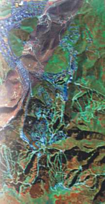
Above right: This hyperspectral image shows Park City, Utah, as seen by the AVIRIS sensor. The background image was taken from 60,000 feet. Its resolution is 17-20 meters per pixel. The image superimposed diagonally across the main image was taken from an altitude of 15,000 feet and is 2-4 meters per pixel. This image shows Park City at a higher resolution, as well as nearby ski slopes (such as the white curves just south of Park City in the lower left portion of the image). Image supplied courtesy of Barnaby Rockwell of the U.S. Geological Survey.
The following pages
offer examples of remote sensing images that are tools for monitoring acid
mine sites.
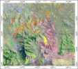
Vegetation classification image derived from Compact Airborn Spectrographic Imager (CASI) airborne sensor data |
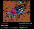
Identification of mineral separations by color |
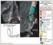
Map derived by applying a spectral angle mapping algorithm to the visible and near-infrared channels of an airborne imaging spectrometer |
Henderson is president of Hendco Services and is a stakeholder facilitator for EPA Region 8 and ISSI.
 |
Geotimes Home | AGI Home | Information Services | Geoscience Education | Public Policy | Programs | Publications | Careers |