Geotimes Home | Calendar | Classifieds | Subscribe | Advertise |
Geotimes
Published by the American Geological Institute |
November
2000
Newsmagazine of the Earth Sciences |
![]() |
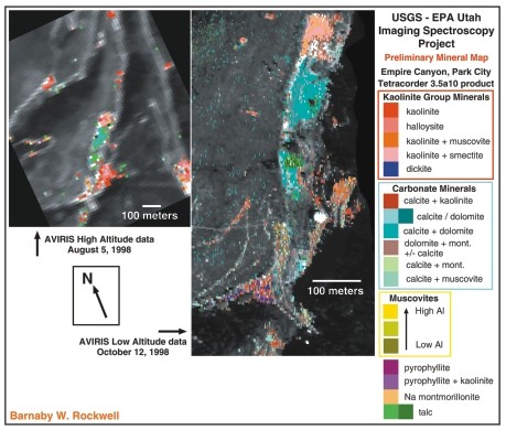
What: Identification of mineral separations by color Where: Waste rock piles in Empire Canyon, Park City mining district, Utah. Resolution: Left: 17-20 meters. Right: 2-4 meters From: Left: AVIRIS flown at 60,000 feet on ER-2 aircraft. Right: AVIRIS flown at 15,000 feet on Twin Otter aircraft. Image analysis performed by Barnaby Rockwell of the U.S. Geological Survey Spectroscopy Laboratory in Denver (http://speclab.cr.usgs.gov). The paper containing these images is available at: http://speclab.cr.usgs.gov/earth.studies/Utah-1/park_cityAV5.html.
|
One of the impressive benefits of hyperspectral remote sensing is the
high degree of mineral separation and identification it allows. Here, the
individual picture elements, or pixels, that contained minerals present
in the USGS spectral library have been color coded by mineral type. These
color-coded pixels are superimposed over a grayscale image. Pixels that
contain other minerals or materials such as vegetation are thus colored
black or gray.
This image shows a comparison of the distribution of minerals mapped
from the 1998 high and low altitude AVIRIS data in the 1.4- to 2.5-micron
spectral region (including clays, carbonates, sulfates and micas). The
northern end of the waste pile contains rock extracted from near the mineralized
ore zone in which abundant pyrite and clay are present. Further south,
waste rock was extracted from barren carbonate-bearing lithologies (some
of which were metamorphosed to talc) that contain little to no sulfides.
These lithologies could serve as buffers to the acidic solutions generated
by oxidizing sulfides elsewhere in the waste rock pile.
![]() |
Geotimes Home | AGI Home | Information Services | Geoscience Education | Public Policy | Programs | Publications | Careers ![]() |