geotimesheader
Feature
REMOTE
SENSING FOR ACID MINE SITES
 |
What:
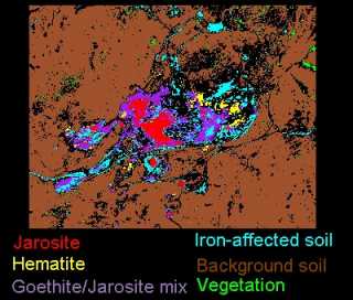
Map derived by applying a spectral angle mapping algorithm to the visible
and near-infrared channels of an airborne imaging spectrometer.
Where:
The Dragon Clay Pit in the Tintic Mining District
Resolution:
5 meters GSD
From: Earth
Search Science Inc.s Probe 1 data processed by Farr View Consulting.
|
The Dragon Mine was mined for the clay mineral halloysite and for base
and precious metals. The waste materials remaining on the site today include
iron oxides and acid associated jarosite (hydrated iron sulfate).
This image maps carbonates as well as iron oxide and sulfate minerals.
At the north wall of the open-pit mine, light blue indicates calcite and
yellow indicates hematite. The hematite also marks the east-west Dragon
fault. The central red zone, which is the central waste dump, indicates
surface jarosite.
Surrounding it is a jarosite-goethite mixture, appearing purple, that
extends west along two mine tailings and may be associated with acid production.
The jarosite commonly occurs mixed with goethite and other hydrous iron
oxides. In non-buffered mine wastes (those not containing carbonates) jarosite
is an indicator mineral for potential acid and toxic metals pollution.
However, because of the Dragon Clay Pit is arid, the downstream transport
of this type of pollution is minimal.
Back to main article.
