geotimesheader
Where
on Earth?
Do you have slides and photos you've collected from field work or
vacations? Every month, we'd like to feature one of your photos from anywhere
in the world and invite other readers to guess where it was taken. Look
every month in the print Geotimes for a new photo. Following are
clues, answers and winners from past issues.
Submit photos for Where
on Earth?
| The first three readers to identify the location
pictured in the current print version of Geotimes receive a Brunton
8099 EclipseTM compass and the first 10
will receive a Where on Earth? T-shirt. Please note that all contestants
are eligible to win one compass per year. |
Answers to
the October and September
photo contests:
Archive
of old answers
October
 |
Clues:
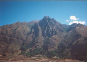
1.
An interannual climate phenomenon brought severe floods and landslides
to this valley in 1998, claiming many lives and destroying a hydroelectric
plant.
2.
Within one 100-mile section of this mountain belt, the vertical distance
between its high peaks and the bottom of the subduction trench offshore
is as much as 14,000 meters (47,000 feet).
3.
Tucked away in this mountain is an important archeaological site, one of
many that dot the entire valley, which terminates at the remains of an
ancient city forgotten until discovered by an archeologist in 1911.
Scroll down for the answer
... |
Answer:
This mountain overlooks the colonial city of
Pisac in south-central Peru's Urubamba valley, named for the river flowing
through it. Also called the Sacred Valley, it was important to the
Inca and houses many Inca ruins, including the ruins of Pisac, nestled
behind this mountain, and the well-known city of Machu Picchu, which sits
at the valley's northern end. |
October winners:
George Dasher Elkview, WV
David King Auburn, Ala.
David Keating
Ryan Christiansen. DeKalb, Ill.
Paul Butler Olympia, Was.
Mauri Pelto Dudley, Mass.
Jim Humphrey Midland, Tex.
Michael Siemens Rolla, Mo.
Jeff Amato LasCruces, N.M.
Seigfried Hamann Huntington Beach, Calif.
September
clues & answer:
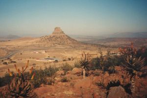 |
Clues:
1.
The cap rock of the hill is a dolerite sill that formed during the breakup
of Gondwanaland. The sill intruded sedimentary rocks that form the rest
of the hill and surrounding plain. They belong to a lithologic group that
contains this country's main source of coal.
2.
In 1879, an indigenous army defeated British troops here in the first major
battle of an eight-month war.
3.
On Christmas Day in 1497, Portuguese explorer Vasco de Gama sighted the
coast of the province in which this hill is located. This sighting inspired
the province's name.
Scroll down for the answer
... |
Answer:
Isandhlwana Hill in the Kwazulu Natal Province of South Africa. Isandhlwana
Hill is a Karoo dolerite (Jurassic age) intrusive into Permian shales/sandstone
of the Pietermariztburg and Vryheid Formations, Ecca Group, Karoo Supergroup. |
September winners:
John L. Snyder Arlington, Va.
William Smith McLean, Va.
George Dasher Elkview, WV
David T. King, Jr. Auburn, Ala.
David J. Wronkiewicz Rolla, Mo.
William M. Jordan Lancaster, Penn.
Bill Laughlin
Jesse Dann Cambridge, Mass.
Skip Blanchard
Dick Swainbank Alaska