Geotimes
Web
Extra Friday,
November 7, 2003
Remote
mapping in disaster zones
When natural disaster strikes, such as the recent
fires in Southern California or severe floods in Europe in 2002, quick assessment
of the land damage can be the difference between a life saved or lost. Researchers
at Columbia University's Lamont-Doherty Earth Observatory and California Institute
of Technology's Jet Propulsion Laboratory recently published findings that they
say prove that synthetic aperture radar (SAR) polarimetry can do a better job
of assessing disaster damage than current optical remote sensing technologies,
such as Landsat.
SAR is an airborne or spaceborne radar tool for looking at Earth's surface
and is especially beneficial when looking at land deformation. The SAR polarimetry
instruments use a single antenna to detect changes in the surface materials.
For example, bare surfaces produce a single "bounce" back to the antenna
on the polarimetry instrument, whereas trees or other ground cover produce more
random prints.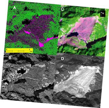
SAR imaging has a clear advantage over other remote-sensing technologies: SAR
instruments can obtain accurate digital images through cloud or dust cover,
through darkness, rain or smoke (Geotimes, November
2003). Like other remote sensing technologies, SAR sensors send out a radio
wave and collect the reflected signals for interpretation. But where it differs
is that SAR uses radio waves and has its own energy beam. Scientists depend
on the all-weather and day and night capabilities to provide quick natural hazards
assessments.
Comparison of various types of remote
sensing data over the Tsaoling landslide within 18 months of the September 1999
magnitude 7.6 Chi Chi earthquake in central Taiwan.
A.) SAR polarimetry data with long wavelength: Purple = bare surface, green
= forest, black = other (including missing data); B.) SAR polarimetry data with
short wavelength; C.) Landsat imagery: purple = landslide source area and debris
apron, green = forest, dark areas in the lower half of image are lakes impounded
by landslide; D.) another satellite image: light colored areas are the landslide
and the vegetated slopes are dark.
Courtesy ofLamont-Doherty Earth Observatory.
SAR applications can be either flown on aircraft or on satellites. As of right
now, SAR polarimetry instruments are only flown on aircraft, such as NASA's
AIRSAR, a DC-8 airplane. The Lamont and JPL researchers evaluated the effectiveness
of SAR polarimetry by mapping a massive landslide in Taiwan that resulted from
a magnitude-7.6 earthquake in 1999. The landslide slid into the Chingshuichi
Valley, killing 34 people and covering about 1.3 square miles of the valley
floor. Their SAR polarimetry data was taken a year after the landslide and they
compared a map of that data with a map taken by Landsat imagery five months
later. "We find SAR polarimetry to be equally proficient, with the critical
added advantage of not needing clear skies to get an image," said Kristina
Czuchlewski, a doctoral candidate at Lamont, in a press release.
As reported in the October Journal of Geophysical Research, the researchers
have developed a classification system for turning the data acquired by SAR
polarimetry into detailed maps depicting landscape elements such as water, vegetation,
rocks and elevation on a very small scale. This classification is the first
step in developing maps of damaged landscapes to provide to rescue workers in
a disaster. Various hazards change the radar scattering properties of the terrain,
so the researchers are developing a set of algorithms for the differing hazards.
They currently have developed algorithms for landslides and have almost completed
a suite for wildfires. In the works, the geologists have algorithms for lava
flows and floods, says Jeffrey Weissel, a geologist at Lamont, and team leader.
The SAR maps could also help predict where disasters will strike next by, for
example, mapping a hillside that's been denuded by fire and is at risk for landslides
with the onset of rain. "We want to develop a system that can be deployed
all over the world in a very short period of time, as hazards are occurring,"
Weissel says.
He says the best way to do that is to put SAR polarimetry instruments on unmanned
aircraft, especially because for the price of one satellite, they could deploy
20 to 30 unmanned planes around the world. In addition to being relatively inexpensive,
Weissel says that the unmanned planes have several advantages over the DC-8s.
Some unmanned aircraft have long hover times, meaning they can stay in flight
over a disaster site for 40 to 60 hours — much longer than a pilot can
safely stay in the air. That ability also allows the vehicles to image events
that last for days, Weissel says, including volcanic eruptions, wildfires and
floods. The unmanned aircraft can also be used in risky situations where it
may be too dangerous to send human pilots, such as above an erupting volcano.
The aircraft fly above the civil airspace, eliminating the potential for disturbing
commercial flight.
NASA is currently looking to retire the AIRSAR plane: These unmanned planes
might be the next step.
Megan Sever
Links:
"SAR: A Versatile New
Tool for Earth Science" Geotimes, November 2003
Earth
Institute at Columbia University
NASA
Earth Observatory
AIRSAR
Mission
Back to top
