
 The
arid Southwest is known for its open spaces and expansive vistas, but some of
the most interesting features are the tight, winding slot canyons hidden from
view. Buckskin Gulch, in the Paria Canyon-Vermillion Cliffs Wilderness Area
that straddles the Utah-Arizona border, is one of the best places to explore
these claustrophobic canyons.
The
arid Southwest is known for its open spaces and expansive vistas, but some of
the most interesting features are the tight, winding slot canyons hidden from
view. Buckskin Gulch, in the Paria Canyon-Vermillion Cliffs Wilderness Area
that straddles the Utah-Arizona border, is one of the best places to explore
these claustrophobic canyons.
Buckskin Gulch is the deepest slot canyon in the Southwest and perhaps the longest
in the world — no one knows for sure. The narrowest section of the canyon
is almost 13 miles long and, in places, no more than arms' width apart. Only
during the peak hours of the day does sunlight reach the canyon floor, hundreds
of feet below the canyon's rim.
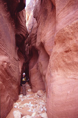
In many places, the steep walls of Buckskin Gulch are only arms-width apart. The canyon is carved out of Navajo sandstone and its characteristic aeolian cross-bedding (left side of photo) is visible throughout. Strewn about the canyon floor are a variety of rocks washed down during flash floods, which are responsible for most of the present-day erosion. All photos courtesy of Jay Chapman.
The history and origin of the deep canyons in the Colorado Plateau, including
the Grand Canyon, is complicated. The current thinking is that features like
the Grand Canyon and Buckskin Gulch are relatively young — 5 to 10 million
years old, says Sarah Tindall, a structural geologist at Kutztown University
in Pennsylvania, who conducts research in the area. Geologists continue to debate
the exact scenario for forming the canyons, she says, but it appears that most
of the incision is related to either regional uplift or stream capture.
Although regional events helped to shape the canyons, flash floods are responsible
for the majority of the day-to-day erosion. The Paria Canyon area experiences
several flash floods each year, and the Buckskin Gulch drainage basin extends
all the way to Bryce Canyon National Park, more than 30 miles away, so it does
not have to be raining in the immediate vicinity to cause a flash flood.
The vertical canyon walls are carved out of the 180-million-year-old Navajo
sandstone, which was once a great dunefield comparable to the present-day Sahara.
Visible on the canyon walls are aeolian cross-beds that formed as sand dunes
migrated across the landscape in the early Jurassic. In some locations, the
walls are covered with so-called desert varnish, which is a mixture of manganese
and iron oxides and has an oily sheen to it. Throughout the Southwest, Native
Americans have carved petroglyphs into the varnish; in Buckskin Gulch, there
are images of big-horn sheep, snakes and other symbols. 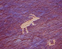
Many rock surfaces in the Southwest are
covered with desert varnish, a mixture of iron and magnesium oxides. In Buckskin
Gulch, Native Americans have carved petroglyphs of big-horn sheep, snakes and
other figures.
To explore Buckskin Gulch on your own, take U.S. Route 89 from Page, Ariz., over the Glen Canyon Dam and into Utah toward Kanab. Near milepost 26, the road takes a sharp turn to the north and begins climbing the East Kaibab monocline. At the end of the sharp turn, there is a small, unmarked dirt road off to the left (south). It is easy to miss, so bring a good map. The road is well-maintained and suitable for two-wheel-drive vehicles. In about 4 miles, a signpost marks the Buckskin Trailhead. If you begin hiking here, you will have to slosh through a few miles of deep sand and unexceptional scenery to get to the slot canyon, but the trail is almost impossible to lose. A better option is to drive another 4 miles to the Wire Pass Trailhead that provides quicker access to the canyon, although the trail can be difficult to follow in places. There is a small parking lot and $5 day-use fee at both trailheads. For overnight camping and backpacking, a $10 permit must be purchased in advance from the Bureau of Land Management.
For almost all hikers, Buckskin Gulch is an in-and-out hike. The canyon winds its way for 14 miles to the confluence with the Paria River, near the Utah-Arizona border. At the intersection, there is a lovely sandbank lined with cottonwood trees that makes a good campsite if you are planning an overnighter.
Jay Chapman
Geotimes contributing writer
Links:
Slot
canyons of the American Southwest
Bureau
of Land Management
 |
Geotimes Home | AGI Home | Information Services | Geoscience Education | Public Policy | Programs | Publications | Careers |