
 Several
forces batter coastal areas everyday: erosion, the onslaught and retreat of
floodwaters from tropical cyclones and hurricanes, El Niño events, winter
storms and tsunamis. Scientists only have reliable records of the impact of
such events on coastal landforms and ecosystems from the past few centuries,
particularly in developing countries.
Several
forces batter coastal areas everyday: erosion, the onslaught and retreat of
floodwaters from tropical cyclones and hurricanes, El Niño events, winter
storms and tsunamis. Scientists only have reliable records of the impact of
such events on coastal landforms and ecosystems from the past few centuries,
particularly in developing countries.
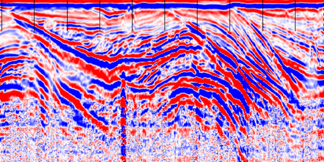
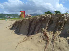
A berm scarp in southern Brazil shows
characteristic signatures of erosion. Geophysical imaging (far right) of sediments
bearing heavy minerals at the scarp’s base reveal past storm activity and
shoreline change over time. All images courtesy of Ilya Buynevich.
But because many coastal barriers around the world developed over the past 3,000
to 5,000 years, most of their dynamic history is archived within their sediments.
Using these sediments, researchers can take an integrated approach to understanding
how beaches, dunes and coastal inlets respond to a variety of natural phenomena
by reconstructing their past behavior over thousands of years. Such reconstructions,
which are getting a boost from new below-surface imaging technology, are particularly
important to coastal communities coping with rising sea levels, diminishing
sand supplies and increasing population pressures.
Using geologic data, scientists are able to determine the locations and extent
of past coastal erosion, allowing them to assess the vulnerability of a particular
shoreline segment to future storm impacts. For example, in the past 200 years,
a number of severe hurricanes and nor’easters (winter storms) have battered
the U.S. East Coast, leading to extensive beach and dune erosion, property damage,
storm surge inundation and even formation of new inlets. For example, Moriches
Inlet along the southern shore of Long Island, N.Y., owes its origin to a 1931
nor’easter, while Shinnecock Inlet to the north was born during a powerful
hurricane in 1938.
Massive damage to coastal communities and dramatic landscape changes associated
with large storms can be understood better when put in the context of long-term
evolution of coastal systems. Studying the layering and composition of beach
deposits, especially the historic surface that records the missing sediments
removed by erosion, shows how the landscape changed and can thus help model
the impact of future storms.
In the past, geologists studied evidence of coastal erosion through the examination
of surface features such as dunes, and intrinsic properties such as sediment
characteristics. However, natural processes and human-induced changes have modified
or obliterated much of the surficial evidence of past erosion. Still, many of
these signatures of past coastal behavior remain beneath the surface. Sediment
cores and trenches alone may be insufficient to capture subsurface features,
and often lack sufficient continuity to fully describe the coastal zone. To
remedy these limitations, subsurface imaging technology, such as ground-penetrating
radar (GPR), has proven to be successful in providing continuous, high-resolution
images of buried beach and dune sediments.
 Depending
on antenna frequency and properties of geological materials (water retention,
texture, porosity), GPR can image decimeter-sized features to depths of more
than 20 meters below the surface. The technology enables scientists to visualize
the subsurface geology, often in 3-D, by creating a reflection profile based
on the travel time of high-frequency electromagnetic waves (see Geotimes,
October 2005). The technique does not work well in sediments saturated with
saltwater, but many barrier systems contain thick lenses of freshwater, which
have a relatively high permeability that enables imaging. These characteristics
make GPR a practical imaging tool in a variety of coastal settings, and in recent
years, the use of this technology has revolutionized coastal geological research.
Depending
on antenna frequency and properties of geological materials (water retention,
texture, porosity), GPR can image decimeter-sized features to depths of more
than 20 meters below the surface. The technology enables scientists to visualize
the subsurface geology, often in 3-D, by creating a reflection profile based
on the travel time of high-frequency electromagnetic waves (see Geotimes,
October 2005). The technique does not work well in sediments saturated with
saltwater, but many barrier systems contain thick lenses of freshwater, which
have a relatively high permeability that enables imaging. These characteristics
make GPR a practical imaging tool in a variety of coastal settings, and in recent
years, the use of this technology has revolutionized coastal geological research.
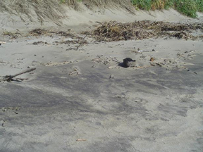
A dune scarp in mid-coastal Maine has
extensive heavy-mineral deposits at its base that show up in images of the subsurface.
In many parts of the world, GPR surveys have been instrumental in reconstructing
past surfaces. In particular, erosional features such as buried storm scarps
produce prominent reflections in GPR surveys due to their distinct geometry,
often complemented with heavy-mineral concentrations — thus recording major
storm events. For example, a series of buried erosional scarps have been imaged
at Hunnewell Beach, Maine, and Crane Beach, Mass., where sediments bearing heavy
minerals (magnetite, ilmenite, garnet) cover the beach following intense storms.
Similar mineralogical signatures of beach erosion, which are sometimes accompanied
by gravel or shell-rich horizons, can be found on many beaches around the world.
Such signatures also can reveal a several-millennia-long archive of erosional
events for expanding coastal systems.
After mapping an area, scientists can then determine the age of a particular
coastal event by radiocarbon dating the organic sediments associated with buried
erosional features or by dating a sand grain’s last exposure to sunlight
at the surface. This information is crucial for determining the timing and recurrence
of extreme coastal events in different parts of the world.
During intense storms or tsunamis, incision and breaching of narrow coastal
barriers may sometimes lead to formation of new inlets. In areas where sand
or vegetation bury and mask historical and relict inlets, their channels may
often be recognized in geophysical records as a legacy of the shoreline’s
dynamic past. In this case, GPR imaging is used not only for identifying buried
channels, but also for providing information on the channel location, dimensions
and geometry prior to closure.
Without GPR, such information rarely can be obtained for historical inlets and
is unavailable for relict channels. But using GPR at Oyster Pond on Cape Cod,
Mass., for example, researchers discovered an old channel beneath a small barrier
beach.
This pond was the focus of K.O. Emery’s classic investigation of a coastal
pond by oceanographic methods in the 1960s, where he used a suite of geological
and geochemical techniques to understand in detail the evolution of a small
coastal water body. Similar to many barrier beaches in formerly glaciated regions,
the gravel content of the barrier fronting Oyster Pond makes core extraction
a challenge. However, this same characteristic produces prominent reflections
in geophysical records due to its contrast with the overlying finer-grained
sediments.
The recent GPR survey at Oyster Pond not only imaged a small eastern inlet that
was depicted on historical charts from the late 1700s to early 1800s, but also
revealed a larger channel structure along the central part of the barrier beach.
The latter was approximately 60 meters wide and at least 2 meters deep and likely
existed prior to or in between the historic mapping efforts. This channel was
probably from an inlet that originated during a large storm.
This study shows that a larger proportion of the barrier beach structure consists
of channel-fill sediments than previously thought. It also underscores the value
of geophysical imaging in providing information that is otherwise unavailable
from historical documents and one that would be extremely difficult to obtain
using only traditional coring techniques. Such geological information is of
immediate use to coastal scientists and managers, who are constantly looking
at ways to mitigate the impact of future storms on coastal communities by identifying
hotspots of erosion or other types of rapid coastal change. We have already
seen, for example, quite a bit of breaching along the barrier islands of the
Gulf Coast during Hurricane Katrina.
In many coastal settings, the interpretation of key reflections on geophysical
records is greatly facilitated by sediment cores at a few carefully selected
locations. Furthermore, with new advances in dating both organic and inorganic
materials, it is now possible to establish accurate ages for ancient shorelines
and associated erosional features, with the potential of reconstructing coastal
evolution over tens of thousands of years. The identification and mapping of
erosional signatures in a spectrum of coastal settings will undoubtedly continue
to help in evaluating the vulnerability of coastal segments to future storm
impacts.
 |
Geotimes Home | AGI Home | Information Services | Geoscience Education | Public Policy | Programs | Publications | Careers |