
 A
local archaeologist’s discovery of a structure that looked like part of
a Roman burial site during an excavation near an aboveground 3rd century Roman
cemetery in Lamta, Tunisia, piqued Susan Stevens’ interest. An expert in
late- and post-Roman North Africa at Randolph-Macon Woman’s College in
Lynchburg, Va., Stevens wanted to explore the site, located beneath an olive
grove. But because the archaeologists did not have permission to dig on the
private property, she says, they could not ascertain the size, shape or purpose
of the structure.
A
local archaeologist’s discovery of a structure that looked like part of
a Roman burial site during an excavation near an aboveground 3rd century Roman
cemetery in Lamta, Tunisia, piqued Susan Stevens’ interest. An expert in
late- and post-Roman North Africa at Randolph-Macon Woman’s College in
Lynchburg, Va., Stevens wanted to explore the site, located beneath an olive
grove. But because the archaeologists did not have permission to dig on the
private property, she says, they could not ascertain the size, shape or purpose
of the structure.
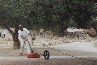
Geoarchaeologist Larry Conyers drags a ground-penetrating radar instrument across
a site in Tunisia. Using the technology, he and colleagues located a church
at least 1,600 years old buried several meters belowground. Courtesy of Larry
Conyers.
 This
past spring, Stevens and Larry Conyers, a geoarchaeologist at the University
of Denver in Colorado, traveled to Tunisia to try to figure out just what might
be buried beneath this olive grove. But instead of digging up the 30- by 40-meter
area, Conyers and Stevens took a small electromagnetic-signal-detection box
and dragged it over the land in a grid pattern for a few hours. When they were
done, they uploaded the collected data to a computer and created a profile of
the subsurface. They knew almost immediately they had found something “way
more exciting than catacombs,” Conyers says. After further analysis, they
realized they had found a Roman Christian church from the 4th or 5th century.
This
past spring, Stevens and Larry Conyers, a geoarchaeologist at the University
of Denver in Colorado, traveled to Tunisia to try to figure out just what might
be buried beneath this olive grove. But instead of digging up the 30- by 40-meter
area, Conyers and Stevens took a small electromagnetic-signal-detection box
and dragged it over the land in a grid pattern for a few hours. When they were
done, they uploaded the collected data to a computer and created a profile of
the subsurface. They knew almost immediately they had found something “way
more exciting than catacombs,” Conyers says. After further analysis, they
realized they had found a Roman Christian church from the 4th or 5th century.
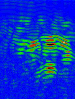
The top of the image shows the ground
surface, which is an olive grove; the top green and red part shows the ceiling
of the church, and the bottom green and red part marks the floor of the church.
Courtesy of Larry Conyers.
The “box” Conyers and Stevens used is a geophysical tool called ground-penetrating
radar (GPR). The device collects and records data from the subsurface, allowing
users to map buried features, including buildings and artifacts. GPR has been
around since the 1950s, but it was not until the 1970s, when a commercially
available GPR system became available, that it actually gained much practical
application. The geophysical tool was developed for mapping subsurface soil
properties and the depth to water tables, and for seeing through glacial ice.
Only in the last decade have geologists and archaeologists begun collaborating
to use the technology in archaeological research.
GPR measures how long it takes for high-frequency (15 to 1,500 megahertz) electromagnetic
pulses to travel from a surface antenna in the box into the ground and back
to the surface. Every surface has chemical and physical properties that reflect
electromagnetic signals uniquely, Conyers says. Those different reflections
from a buried object or layer will produce a somewhat horizontal line in a “reflection
profile.” Putting together thousands of radar reflections yields a 3-D
picture of soil, sediment and feature changes, he says.
In the profile of the area below the Tunisian olive grove, “we could see
the arch of the nave, the top of which is about 2.5 meters belowground,”
says Conyers, who began his career in the oil industry using geophysical tools
like seismic profiling and later translated that knowledge for archaeological
use. Below the arch, they could see the floor of the ancient church, which appears
to be bowed upward, and other features such as archways and doorways.
GPR provided “a hint and a help” with what’s there, Stevens says,
but she still has to go back to the site and “dig in the dirt” to
find a detailed picture. Stevens hopes to excavate the site next summer, now
knowing what she is looking for.
The beauty of using GPR to locate buried treasures such as the Roman church
is not only that it produces high-resolution images, but also that it is noninvasive,
Conyers says. “Most archaeological discoveries are made by somebody accidentally
stumbling upon something, and digging a hole or a trench to see if they can
find more,” he says. GPR doesn’t require the destruction of ground;
“you can simply run the survey.”
Furthermore, as GPR can see through almost any type of groundcover (including
concrete and asphalt), once a site is found, a GPR survey could “take you
from the known to the unknown very quickly, and in 3-D,” Conyers says.
“Then you know the best place to dig an excavation hole,” so as not
to destroy anything and to have the most fruitful excavation.
The quality of a profile that’s collected depends largely on the type of
soil, says Matthew Turner, senior geophysicist with GeoModel Inc., a geophysical
consulting firm based in Virginia that has recently begun collaborating with
archaeologists on some projects. Sandy soils, for example, tend to reveal more
than clays do, he says. And generally, drier soils are better electromagnetic
conveyors than wetter soils. Volcanic ash, Conyers adds, is one of the easiest
soils to see through. That’s why the ancient city of Pompeii, which was
buried by a volcanic eruption in A.D. 79, is an ideal location for using GPR.
People have been excavating the site since 1748 with varying degrees of success,
but using GPR, archaeologists could “map the rest of Pompeii very quickly,”
Conyers says. Indeed, Turner says, running the radar across a site can take
only a couple of hours for small sites to a couple of days for larger ones.
Furthermore, Conyers adds, one person running a GPR box over a site usually
costs a lot less than a team of excavators digging out a location.
The two possible downsides of using GPR at an archaeological site, Conyers says,
are that if the soil is not a good electromagnetic conveyor, the survey might
not yield a good profile, and that the survey can only go a maximum of 5 meters
belowground, as was the case in Tunisia (the average depth is 2 to 3 meters).
Also, GPR works best as an archaeological tool when researchers define an area
in which to search. It’s not worth the time or effort to “go out and
wander aimlessly” looking for something belowground, he says.
Using GPR, Conyers has found a buried Roman church in Jordan, an ancient Maya
site buried beneath meters of volcanic ash in El Salvador, and the original
Native American pueblos beneath a parking lot in downtown Santa Fe, N.M., among
many other finds. Turner has likewise located an old sugar processing mill in
Florida and the original city of Port Royal in Jamaica, which was destroyed
and buried by an earthquake in 1692. The list of places where GPR could be useful
is endless, Conyers says.
In addition to GPR, “a variety of other earth science techniques can be
applied to different archaeological materials or problems with diverse time
and geographic origins,” wrote Leanne Mallory-Greenough and John Greenough
of Okanagan University College in the June 11, 2004, Canadian Journal of
Earth Sciences. Over the past decade, they wrote, earth scientists have
been finding that they can make a big difference in archaeology.
For example, geologic dating techniques that measure how long sediments were
exposed at the surface before being buried, such as optically stimulated luminescence,
can be applied to a variety of important archaeological artifacts, such as burnt
stones and ceramics, which are notoriously difficult to date. Other techniques,
including X-ray analyses and instruments that can read chemical signatures,
can reveal the authenticity of artifacts while dating them, for example revealing
a 500-year-old case of mining fraud in Canada (see Geotimes,
October 2004). These types of tools can help trace artifacts to their original
locations, helping to chart ancient trading paths, they wrote.
Archaeologist William Kelso of the Association for the Preservation of Virginia
Antiquities and colleagues have used a number of these geophysical tools in
concert to investigate the Jamestown settlement in Virginia, first inhabited
around 1602. They have located buried brick piles and cellars, dated artifacts,
and are using such tools to pinpoint the original boundaries of James Fort.
This past summer, using GPR beneath a church in England, they found a 400-year-old
vault that has helped in the quest to identify the remains of the original man
who colonized Jamestown. “I’m a believer that these technologies will
move forward the field of archaeology,” Kelso says.
Remote sensing, such as satellite and digital elevation imagery, is also moving
archaeology forward, especially in places like the Middle East and Egypt (see
Geotimes, February 2004), says Tony Wilkinson, a
geoarchaeologist at the University of Edinburgh in Scotland. Using Corona satellite
images from the 1970s, for example, Wilkinson says, he and colleagues have seen
forgotten roadways in ancient Mesopotamia, which form grooves in the landscape
and are not visible from the ground. They have also seen archaeological sites
“poking up as mounds, or tells,” and levees lining ancient waterways.
“There’s tremendous potential” for using geophysical tools in
archaeology, Wilkinson says. “When we put geophysical tools with standard
archaeological excavations and ground-truthing, we can get the best possible
archaeological picture and really move forward.”
Megan Sever
Links:
"Satellites
reconstruct ancient Egypt," Geotimes, February 2004
"Elizabethan gold riddle
solved," Geotimes, October 2004
"Inspectors
armed with geophysics," Geotimes Web Extra, Nov. 27, 2005
"The Quest
for Better Wine Using Geophysics," Geotimes, August 2004
"Narrowing the radio spectrum for geoscience," Geotimes,
July 2002
Back to top
 |
Geotimes Home | AGI Home | Information Services | Geoscience Education | Public Policy | Programs | Publications | Careers |