
|
 Subscribe

NEWS NOTES
Natural Hazards
Tsunami risk high in Myanmar
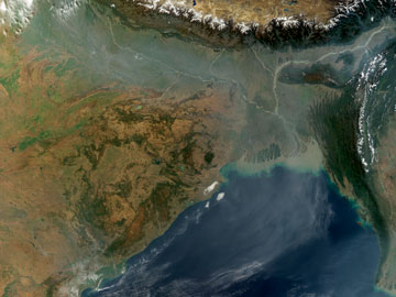 NASA image created by Jesse Allen, Earth Observatory, using data courtesy of the MODIS Rapid Response team |
| Once thought to be relatively seismically quiet, the northern Bay of Bengal, shown here bounded by the Ganges Delta to the north and Myanmar to the east, may be prone to large, tsunami-spawning earthquakes. |
Once thought to be relatively seismically quiet, the northern part of the Bay of Bengal may instead be prone to giant earthquakes that could spawn tsunamis, with potentially devastating consequences for the bay’s densely populated coasts, according to a new study.
Since the 1980s, scientists have thought that the same subduction zone that spawned the devastating 2004 Sumatra-Andaman earthquake — which marks where the tectonic plates bearing India and Southeast Asia meet — continues north through the Bay of Bengal and along the Myanmar coast. Despite that connection, however, it also appeared that the danger of large earthquakes in the more northern part of the bay was minimal, as previous data from that region did not show any active subduction.
That evidence for a lack of tectonic activity was “not compelling,” however, according to Phil Cummins, a senior seismologist at Geoscience Australia. “In fact, most of the geological evidence indicates the opposite,” he told reporters at a press briefing Sept. 4. That evidence includes changes in coastal land levels, with uplift to the south and subsidence to the north — changes that suggest a rupture length of at least 500 kilometers, and that would be consistent with an offshore locked-thrust fault, a type of active subduction zone fault capable of generating powerful “megathrust” earthquakes such as the Sumatra-Andaman temblor. Additionally, Cummins said, new GPS measurements of tectonic deformation along the coast also suggest that there is active subduction in the region, he reported Sept. 6 in Nature.
Whether there have been large tsunamis in the region in the past is also uncertain. In 1762, a powerful earthquake occurred at both the northern and southern ends of the fault, causing a rupture more than 500 kilometers in length. Although accounts tell only of local tsunamis resulting from this earthquake, this type of earthquake “could generate a large tsunami, which could impact the densely populated Ganges Delta” north of the Bay of Bengal, Cummins said. To determine the potential impact of such an event, he simulated a tsunami generated by a magnitude-8.8 earthquake along the coast, and found that such a tsunami could potentially impact a million people. Based on current deformation measurements in the area, it could take another 200 years for stress to build up to pre-1762 levels, although smaller ruptures could generate earthquakes much sooner.
Although the study highlights that the Myanmar coast has the potential for large, tsunami-generating earthquakes, Cummins said he sees his work as a preliminary step. “This calls for further scientific work,” he said.
Indeed, “much work would have to be done to determine whether such a large rupture of the megathrust” off the Myanmar coast, and a subsequent tsunami, is likely, says Kerry Sieh, a geologist at Caltech in Pasadena, Calif. Cummins’ analysis of the historical record and his models of the effects of a potential earthquake are both credible, Sieh says, but with the still-scant paleoseismic evidence available for the region, “no one knows the details of how the megathrust there behaves.”

