
Geotimes Home | AGI Home | Information Services | Geoscience Education | Public Policy | Programs | Publications | Careers

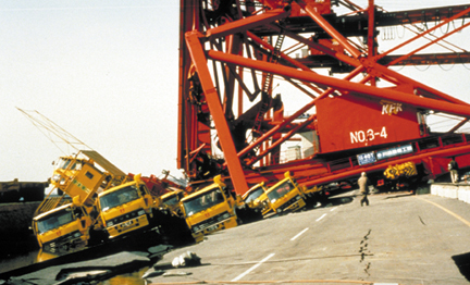 Almost eight years
have passed since the Great Hanshin-Awaji Earthquake devastated Kobe, Japan. Striking
directly below the bustling urban center on Jan. 17, 1995, the magnitude-7.0 earthquake
killed more than 6,000 people, destroyed thousands of homes and buildings, and
wrecked critical infrastructure systems. Kobe, Japan’s sixth largest city
and second largest port, until then was considered one of the most quake-safe
cities in Japan.
Almost eight years
have passed since the Great Hanshin-Awaji Earthquake devastated Kobe, Japan. Striking
directly below the bustling urban center on Jan. 17, 1995, the magnitude-7.0 earthquake
killed more than 6,000 people, destroyed thousands of homes and buildings, and
wrecked critical infrastructure systems. Kobe, Japan’s sixth largest city
and second largest port, until then was considered one of the most quake-safe
cities in Japan. 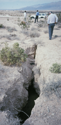 By 1968, Las Vegas
residents were pumping an average 88,000 acre-feet every year. Also by that time,
surveyors had noticed that the city was sinking.
By 1968, Las Vegas
residents were pumping an average 88,000 acre-feet every year. Also by that time,
surveyors had noticed that the city was sinking.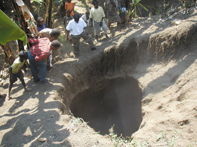 When it comes to a
city’s volcanic risk, the threat depends on the neighboring volcano and what
historically has vented out or fallen down: mudflows or lahars, pyroclastic flows,
pahoehoe and `a`a lava flows, ash or toxic gases. With well over 50 million people
worldwide living or working near a potentially dangerous volcano, it is difficult
to single out a particular city at risk. Around the globe, 59 major cities conduct
business as usual on top of historic lava flows or under the occasional dusting
of ash, says Henry Gaudru, president of the European Volcanological Society’s
International Commission on Mitigation of Volcanic Disasters in Geneva.
When it comes to a
city’s volcanic risk, the threat depends on the neighboring volcano and what
historically has vented out or fallen down: mudflows or lahars, pyroclastic flows,
pahoehoe and `a`a lava flows, ash or toxic gases. With well over 50 million people
worldwide living or working near a potentially dangerous volcano, it is difficult
to single out a particular city at risk. Around the globe, 59 major cities conduct
business as usual on top of historic lava flows or under the occasional dusting
of ash, says Henry Gaudru, president of the European Volcanological Society’s
International Commission on Mitigation of Volcanic Disasters in Geneva. 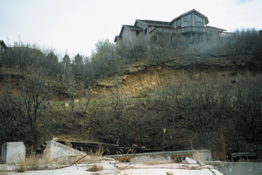 Geology and topography
make landslides an ever-present risk in Colorado Springs — a risk that becomes
more dangerous as people continue to move to the foothills west of the city center.
These higher elevations are prime real estate, offering spectacular views of the
city.
Geology and topography
make landslides an ever-present risk in Colorado Springs — a risk that becomes
more dangerous as people continue to move to the foothills west of the city center.
These higher elevations are prime real estate, offering spectacular views of the
city. |
Geotimes Home | AGI Home | Information Services | Geoscience Education | Public Policy | Programs | Publications | Careers |