
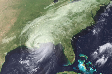
 One of the
largest hurricanes to make landfall in the U.S. Gulf Coast region since Hurricane
Camille in 1969, Hurricane Katrina left a trail of devastation behind it as it
touched down in Louisiana, Mississippi and Alabama on Aug. 29. The storm affected
not only the Gulf communities and shorelines it passed, but also the oil and gas
market (see story, page 48, print
exclusive).
One of the
largest hurricanes to make landfall in the U.S. Gulf Coast region since Hurricane
Camille in 1969, Hurricane Katrina left a trail of devastation behind it as it
touched down in Louisiana, Mississippi and Alabama on Aug. 29. The storm affected
not only the Gulf communities and shorelines it passed, but also the oil and gas
market (see story, page 48, print
exclusive).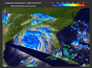 A
typical thunderstorm often illustrates that lightning and rain go together —
but not always. The more important partnership may be between lightning and
ice in a storm cloud. New observations recently confirmed that lightning follows
clouds’ ice content, potentially providing climate scientists with a new
method of measuring water in the atmosphere worldwide — an important component
of global climate models for forecasts.
A
typical thunderstorm often illustrates that lightning and rain go together —
but not always. The more important partnership may be between lightning and
ice in a storm cloud. New observations recently confirmed that lightning follows
clouds’ ice content, potentially providing climate scientists with a new
method of measuring water in the atmosphere worldwide — an important component
of global climate models for forecasts.
This satellite image of Hurricane Katrina, created by combining radar and radiometer
data together from the moment when the storm made landfall, shows the hurricane’s
increased precipitation as it grew to a Category-5 storm. Little white spikes
mark where the Tropical Rainfall Measuring Mission’s Lightning Imaging
Sensor detected flashes of lightning. Note that the detected lightning occurs
in the outer spiral bands of the hurricane, and not at the center. That difference
may be because the clouds forming Katrina’s eye lacked precipitation-sized
ice, a conclusion that requires further research. In the meantime, a new study
has shed light on the role of ice in the occurrence of lightning. Image by Dennis
Boccippio, NASA Marshall Space Flight Center.
“It rains hard usually when you have lightning,” says Walter Petersen
of the Earth System Science Center at the University of Alabama in Huntsville,
but lightning can also happen without rain. However, lightning always occurs
in the presence of ice particles, something determined with observations and
lab experiments in the 1940s and 1950s. The experiments, Petersen says, showed
how three water phases present in a cloud could make graupel pellets —
slightly smaller than hail but bigger than ice crystals — transfer an electrical
charge.
The more graupel, the more lightning, Petersen says, likening a thunderstorm
cloud to a battery. As water vapor is blown up into the cloud, it cools and
condenses to form small cloud droplets and then larger raindrops. These bits
of water become supercooled and eventually freeze as they move up, accreting
together with other ice particles to make graupel pellets, which tend to fall
back down. At the same time, thunderstorm updrafts move ice crystals up in the
cloud. As passing ice crystals collide with the falling graupel, they exchange
electrons. The movement creates an electrical current, basically making one
end of the cloud positive and the other negative — perfect for making lightning.
With that knowledge in hand, Petersen and colleagues examined satellite data
from NASA’s Tropical Rainfall Measuring Mission (TRMM) to look at lightning
flashes around the world, along with the locations of water and large ice particles.
The team compared ice density in the clouds with the amount of flashes produced,
and found that the correlation of the amount of ice with the amount of lightning
stayed steady, whether over land masses or oceans: Increasing the amount of
ice increased lightning flashes proportionally.
“If you look at the oceans or the continents or coastal areas, all these
different areas have different ways to make rainfall,” Petersen says. “The
thing that is consistent in those areas is the mechanism to make lightning:
the presence of this ice mass.”
The new research, published in Geophysical Research Letters on July 26,
is “excellent” and “probably the best documented” if not
the first confirmation of the steady correlation between lightning and precipitation-sized
ice in thunderstorm clouds, says Ken Pickering of the University of Maryland
in College Park.
Because ice is part of the water budget, Petersen says, it is an integral piece
of information for weather and climate modeling. But just how much ice contributes
to the system remains unknown. The research team suggests that lightning measurements
could be a good indication for how much water-ice is present in clouds on a
global scale.
Pickering also suggests that the findings could also help in determining the
chemical impact of lightning on the atmosphere, which catalyzes the production
of ozone by creating nitric oxide — a possible climate feedback loop. Current
satellite instruments, he says, “can’t get an exact count of all lightning
flashes around the world,” and chemical modelers must make estimates based
on meteorological variables. “We may be on a better track to predicting
global flash rates better,” Pickering says, for the next generation of
climate models.
Naomi Lubick
 |
Geotimes Home | AGI Home | Information Services | Geoscience Education | Public Policy | Programs | Publications | Careers |