Web Extra
Monday, October 16, 2006
Strong earthquake shakes
up Hawaii
At
7:07 a.m. local time Sunday, a magnitude-6.7 earthquake rumbled through
the island chain of Hawaii, originating near Hawaii island, known as the
"Big Island," according to the U.S. Geological Survey (USGS).
An aftershock with a magnitude of 6.0 followed seven minutes later.
Hawaii's governor, Linda Lingle, declared a statewide emergency after
the quake, which knocked out power throughout the islands, damaged buildings
and triggered rock slides that blocked roadways. No deaths and only minor
injuries were reported, however, according to an Oct. 15 story by the
Associated Press.
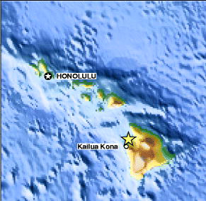
A magnitude-6.7 earthquake struck
off the western coast of Hawaii's Big Island Sunday morning, damaging
buildings and triggering landslides. Image is courtesy of the U.S. Geological
Survey Earthquake Hazards Program.
The earthquake's epicenter was located about 39 kilometers below the
surface and about 10 kilometers off the western coast of the island of
Hawaii, or about 253 kilometers southeast of Honolulu, according to USGS.
Shortly after the event, the National Oceanic and Atmospheric Administration's
Pacific Tsunami Warning Center in Honolulu advised
that neither a Pacific-wide nor a local tsunami was expected to result
from the earthquake.
Although earthquakes are common in Hawaii, Sunday's quake was the most
powerful to strike the state since a 6.7-magnitude temblor in 1983. The
most powerful earthquake ever recorded in Hawaii occurred in 1868, when
a magnitude-7.9 temblor spawned a tsunami that killed 46 people along
Hawaii's southeastern coastline, as well as numerous landslides that killed
36 people.
The Hawaiian islands are the most recent in a 5,600-kilometer-long chain
of volcanoes thought to have formed in the Pacific Ocean as Earth's crust
moves over a stationary "hotspot," a plume of hot magma rising
from deep in Earth's mantle (see Geotimes online,
Web Extra, Aug. 11, 2003). Most earthquakes in Hawaii are related
to volcanic activity and the movement of magma underground, and can occur
either before or during an eruption, according to USGS.
The state's more powerful earthquakes, however, are generally due to stresses
that are more indirectly related to volcanism, says Waverly Person, a
geophysicist at the USGS Earthquake Hazards Program
in Golden, Colo.
"What happens is the stress builds up in the crust from all the volcanoes
on the islands," so that the sheer weight of the islands themselves
creates tectonic stress in the crust, Person says. "That's what causes
an earthquake of this size."
The earthquake's aftershocks "could continue for weeks or even months,"
Person says. In addition to the magnitude-6.0 aftershock that occurred
almost immediately following the main shock, a series of smaller aftershocks
continued to rock the islands Sunday and Monday. As of Monday, power had
already been restored to most of the state and road crews were cleaning
away the rock debris.


 Subscribe