
|
 Subscribe

FEATURE
Polar Robots Do a Cold Job
Derrick J. Lampkin
 Courtesy of Derrick Lampkin |
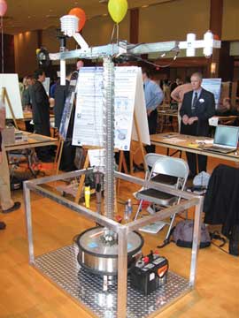
| An important part of the new prototype polar rovers is the “instrument package/deployment” (IPD) assembly, which is composed of meteorological instruments mounted to a dynamic mast system. The instruments will measure radiation, humidity, barometric pressure, surface temperatures, wind speed and wind direction on the Greenland and Antarctic ice sheets. |
“MEN WANTED FOR HAZARDOUS JOURNEY: Small wages, bitter cold, long months of complete darkness, constant danger, safe return doubtful. Honor and recognition in case of success.”
Ernest Shackleton
Announcement for Personnel before Endurance Expedition
Much has changed since the days of Ernest Shackleton, when the men who explored the poles for fame and scientific inquiry faced near-impossible odds for survival. Yet many difficulties remain for contemporary scientists who continue the pursuit of knowledge at the ends of the Earth. Though human scientists will continue to travel to dangerous corners of the planet to perform research, robotic rovers will increasingly do some of the dirty work. We are developing a distributed network of mobile, autonomous and relatively inexpensive wireless robotic rovers capable of measuring climate data in the polar regions and relaying that data to polar scientists. These metal “climatologists” may change the way we perform climate research in Antarctica and the Arctic — and may help us to understand just how the ice sheets respond to climate change.
Continental ice sheets, such as those covering Antarctica and Greenland, constitute the largest part of Earth’s perennial ice masses and play a major role in the stability of Earth’s climate. Yet there is a lot we don’t know about these incredible masses of ice. Ice sheets were once considered passive components of Earth’s climate system, but recent evidence indicates that these structures are dynamic and may be involved in amplifying or driving variability in the climate system. The rovers can help.
The changing mass of ice in Greenland and Antarctica represents the largest unknown in predictions of global sea-level rise over the coming decades. Given the substantial impact these ice bodies can have, improved monitoring of the ice sheet mass balance is of vital concern. Significant advances have been made in leveraging a wide range of observation platforms to monitor ice sheet dynamics, ranging from ground-based to airborne to space-based systems.
Since 1979, robust, ground-based meteorological networks have been in operation throughout Antarctica. The Automatic Weather Station (AWS) network has been expanded over the last several decades, resulting in an observation network of more than 55 stations that measure temperature, relative humidity, wind speed and direction, atmospheric pressure and snow temperature profiles. A similar network was deployed in the mid-1980s. In 1987, the first AWS station was deployed in Greenland; it has since been expanded into the Greenland Climate Network, in which 18 stations collect similar data to the Antarctic network. These data tell us about the processes that control the health of the ice masses.
Large- and moderate-scale investigations are well-served by the spatial distribution of these networks. Many processes in the ice sheet system operate across a range of scales, however, resulting in dynamics that may transcend the utility of the existing AWS network. A scale-adaptable, mobile, autonomous AWS network capable of capturing these vital meteorological measurements could be employed to augment the existing network and capture multi-scale processes currently under-sampled by the stationary system. This is where our rovers come in.
 Courtesy of Derrick Lampkin |
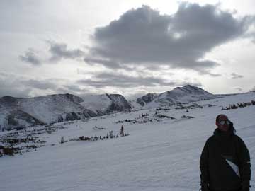
| Derrick Lampkin examines the test site for the new polar rovers at Niwot Ridge, Colo., a location with conditions analogous to those the rovers will face in Greenland when they are deployed next year. |
A robotic climate station requires some basic components to function as stationary units do today: a collection of instruments and a mechanism to place those instruments at the appropriate positions relative to the ground and each other. Our team has recently developed a device that allows the instruments to take measurements at the appropriate positions once the rover unit reaches a target location. This device is a functioning prototype instrument package and deployment (IPD) apparatus.
The IPD package includes instruments that measure the same sort of data that the AWS stations measure — radiation, temperature, barometric pressure, humidity, wind speed and direction — which allow us to determine how much solar energy the ice sheet absorbs, how much energy is radiated back to the atmosphere and how much mass is added or lost as well. Unlike the AWS stations, however, the IPD instrument package is, of course, mobile.
To collect reliable data, all IPD instruments must be elevated at least 1.5 meters above the ice surface. Transporting the instruments while they were elevated is difficult, so the system is equipped with the ability to retract the instruments when the rover is moving and elevate the units when the rover is stationary and ready to record data.
A roving system is no good without the ability to traverse the ice sheet terrain, which is riddled with conditions that range from flat expansive regions to undulating ripples of various sizes called sastrugi. The development of a customized track system capable of transporting the suite of instruments to any specified location on the ice sheet surface is still under way. The IPD will be mounted to a track system complete with storage for power supply, navigation and communication electronics, as well as data logging units.
Getting the collected data from the rover to the laboratory poses another challenge, particularly when the capacity for the rovers to communicate directly to each other may be limited by the terrain. To get around such a limitation, each rover will be outfitted with a transceiver as part of the ARGOS network (a collaborative effort between NOAA and the French Space Agency). This network facilitates data transfer directly to a remote ground station via a satellite link aboard NOAA Polar Orbiting Environmental Satellites platforms.
Although work remains to be done, field testing of the prototype rover at the Niwot Ridge alpine research facility in the Colorado Front Range will begin next year. Niwot Ridge is characterized by low temperatures during the winter, as well as increased solar radiation, high wind velocities and an abbreviated growing season, which make it a good analogue for Greenland. Meteorological data have been collected at Niwot since 1953 from a network of stations ranging in elevation from 2,591 to 3,743 meters.
These data will be invaluable in validating measurements from the robotic system, allowing us to assess system performance. Working at Niwot will allow us to work out the kinks in the rover system before we deploy to the ice sheet where the environment is less forgiving of mistakes. We selected test sites above the tree line to evaluate rover mobility and data collection performance under challenging environmental conditions analogous to those on the Greenland Ice Sheet.
The future of cryosphere monitoring will see a range of innovative robotic systems capable of collecting data from all sorts of rovers and vehicles. The goal, of course, is to help fulfill an important data gap in ice sheet monitoring and to complement existing climate monitoring networks, while reducing the hazards that humans commonly face when working in dangerous environments. It’s a brave new world out there, one where robots will also answer Shackleton’s call.

