
|
|
|
Treasures in a pristine cave
Deciphering life
Looking for kimberlite in Wyoming
Tsunami earthquakes find common ground
Another earthquake in Turkey?
Responding to the mid-Atlantic drought
SEG offers student grants
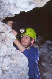
Penny Boston, professor of biology at the University of New Mexico, collects samples from Lechuguilla Cave, N.M. Boston is part of a study of the caves rare microbes and their unique habitats. Courtesy Val Hildreth-Werker: werks@worldnet.att.net |
Over 100 miles of mapped passages, rare speleothems, 20-foot
tall gypsum chandeliers and cave pearls attract cavers from around the
world to Lechuguilla Cave in Carlsbad
Caverns National Park, N.M. But it may be the less obvious microorganisms
recently discovered in the cave, along with their geologically unique habitats,
that are the most scientifically intriguing attractions.
Before May 1986 Lechuguilla was known as a small, insignificant cave mined in the early 1900s for minimal amounts of bat guano. But in the 1950s, cavers heard wind roaring from the caves debris-covered floor. After two years of digging, cavers broke through the debris in 1986, unveiling at least 104 miles of mapped passages in the 1,567-foot deep cavethe deepest limestone cave in the United Statesand providing a new location for studying life in extreme environments. The maze of passages in Lechuguilla also revealed other surprising discoveries: unusual microbes, some of which may not exist anywhere else. Researchers studying the cave hoped its almost untouched habitat would be ideal for studying life in extreme environments. So researchers who have been studying the cave since the 1980s began looking for life in the caves pools and eventually expanded their search into deep, unexplored passages after the pools revealed an abundance of life. |
During the National Speleological Society convention in July in Filer, Idaho, Dale Pate, a cave resource specialist at Carlsbad, addressed questions about current microbiology research in Lechuguilla, and about the idea of limiting access to the cave. While stressing the parks appreciation of volunteer cavers, Pate says that there is a fine balance of access vs. preservation. We strive to keep the cave in as pristine a condition as possible.
The researchers dont know the extent and exact effects of human activity on the caves resident microbes, but evidence suggests that human contact may harm the microbes and their habitats. Pate says, for example, that some research concludes more biological diversity is found in less visited areas of the cave.
| Penny Boston, a research associate professor in the biology
department at the University of New Mexico,
Albuquerque and director of Complex Systems Research Inc., a nonprofit
organization in Boulder, Colo., has been leading the investigation of the
caves microbes and their habitats. The genetic diversity within the cave
is almost impossible to grasp. A large part of it is unknown to science,
she says. Protecting Lechuguilla is important because, unlike a surface
environment, the cave environment doesnt regenerate. Just as there is
a drive to protect rainforests as a surface resource of unknown potential,
Boston says, there should be a push to protect Lechuguilla as a subterranean
resource.
After watching a National Geographic special about Lechuguilla, Boston wanted to find possible microbial habitats in the cave. Eventually, Boston, Diana Northup, a graduate student at the University of New Mexico, and a team of scientists explored the cave for microbes, beginning with an April 1994 expedition. A second expedition in December 1994 convinced Boston that unusual microbes existed within the caves corrosion residue, degrading rock and sulfur deposits. |
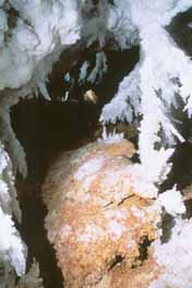
Inside Lechuguilla Cave. Courtesy National Park Service. |
Few caves contain corrosion residue. There is only a sprinkling of information about corrosion residue in caves around the world, Boston says. The residue is a low-density material that consists of clays and minerals, varies in pH, and is rich in rare-earth elements, compared to the parent limestone. A soft, degraded rock layer exists between the corrosion residue and parent rock. Chemically this layer varies little from the limestone.
Organisms probably do not live in the parent rock, as the limestone matrix does not allow enough space for a microbial habitat. But the researchers havent dismissed the possibility, Boston says.
The effect of the caves geology on the microbes and vise versa warrants continuing research. The corrosion residue, the soft layer separating it from the caves parent rock, and sulfur deposits could partly result from microbial processes. We believe that the microbes are mining the rocks, Boston says. Her team still doesnt know under what circumstances the microbes either perpetuate the caves stability by precipitating minerals or deteriorate the cave by producing corrosion residue.
The microbes derive their nutrient supply by oxidizing iron, manganese and sulfur. They might have helped form Lechuguilla through sulfuric acid dissolution by increasing the formation rate of sulfuric acid, Boston says. While secondary processes create speleothems, the portion of the cave theyve explored is no longer in the active sulfur phase, a primary process. There are many ways to manipulate sulfur, so the picture is very complex.
Julia Cole
Geotimes contributing writer
Indeed, Nealson is still doing what he loves. Only now he is developing methods to identify life on other planets. And not just life as we know it, but life of any kind. Earthly bacteria are easy to identify, Nealson says. Its non-Earth organisms that will be harder to find, like those with structures different from DNA. To help identify the fickle foundations of life Nealson is relying on the discernible features of geology. Nealson presented his theories in late August during the International Symposium on Subsurface Microbiology, hosted by the American Society for Microbiology and the U.S. Geological Survey in Vail, Colo.
Nealson and his colleagues at JPL will use synchrotron radiation sourcessuch as those at the Argonne National Laboratory in Chicago, Ill., and the Lawrence Berkeley Laboratory in California that produce X-rays at high energy levelsto look inside rocks collected from other planets. The first step would be to determine density differences to help screen material and keep costs of the project down, Nealson says. Only incongruous rocks may enter the second phase, where they are tested for chemical components. If you see a bunch of chemicals that shouldnt be there, he says, its likely a signal for life.
An aberrant ratio of life elementshydrogen, carbon, phosphate, sulfate or nitrogento the typical rock elementssilicate and aluminumwould provide the golden ticket, the first sign that maybe life exists beyond our own understanding.
Although his ideas are still just ideas, in the next two to three years Nealson is anticipating a chance to test out his theory by analyzing life from extreme environments on Earth. By experimenting with samples from Antarctica, hot and cold deserts, subsurface environments and alkaline lakes, Nealson wants to establish the accuracy of his methods and eliminate any chance that Earthly materials might contaminate the extraterrestrial samples. Nealson has chaired NASA panels on planetary protection (from transferred bacteria or other organisms) in the past and lead discussions on ways to avoid cross contamination between samples from Mars and Earth.
When Mars missions of the future return with rock samples, Nealson will be waiting. His strategy is to develop methods guaranteeing that when scientists do run across unearthly life or its fossil, they wont miss it. I suspect I wont be that lucky to run into it, he says. But God, Id love it if that were true.
Christina Reed
Geotimes
An experienced geologist like Dan Hausel could point out the signs.
Hausel is a senior economic geologist with the Wyoming
State Geological Survey. My job is to identify and evaluate mineral
deposits, gemstones, precious metals and base metals; and to map mining
districts and study Precambrian geology, Hausel says. He recently identified
several new kimberlite deposits in the Iron Mountain District of Wyoming,
an area historically not known for kimberlite deposits. Most of the states
deposits have been found in the southwest near Colorado. Since 1998, Hausel
has identified an estimated 80 percent more kimberlite deposits than were
previously known to exist in the Iron Mountain District.
| What are the signs of kimberlite? Trees do not grow on kimberlite,
but grass will grow slightly taller than usual. Kimberlite is also softer
than the surrounding terrain, so animals dig more burrows in it and expose
the gray, clay-rich soil known as blue ground. Soils over kimberlite
will also contain pyrope garnet, chromium dioxide and picro-ilmenite.
Although not all kimberlite contains diamonds, several other kimberlite deposits in Wyoming are known to. In some of the Iron Mountain kimberlites, Hausel has found G-10 pyrope garnets, which, because they originate at the same depth where diamonds form, can be early indicators of diamonds. |
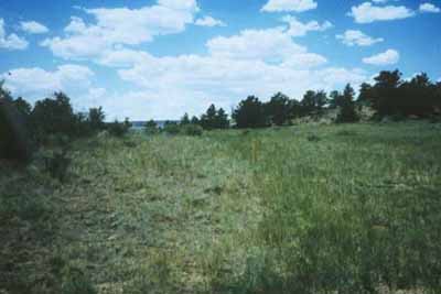
In this image the left side sits over granite, while the right side sits over kimberlite. Courtesy Dan Hausel, Wyoming State Geological Survey. |
Now that Hausel has identified these areas as kimberlite deposits, the survey will collect samples to test for microscopic diamonds, Hausel says. If the deposits contain diamonds, the survey will publicize them and mining companies can then test the soil. In industry, less than 1 part per million of diamond in kimberlite is a good mine, Hausel says.
Kandice Carter
Geotimes contributing writer
Susan Bilek and Thorne Lay of the University of California, Santa Cruz (UCSC) conducted a global investigation to determine the rupture properties of earthquakes in six different subduction zones. Bilek, a graduate student, found that regardless of the plates ages, convergence rates, or supply of sediments, all six of the zones shared a common variation: at shallow depths the rocks were more susceptible to shearing distortions; that is, they all had low rigidity values.
Although her results support the hypothesis that low rigidity and shallow
depths are needed factors in an earthquake that produces an anonymously
large tsunami, they also show that such conditions arent so uncommon.
We were surprised to see the consistency between all the regions, Bilek
says. Our results suggest that tsunami earthquakes can occur in more places
than previously expected.
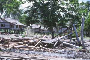
1998 tsunami damage in Papua New Guinea. Courtesy Bruce Jaffe, USGS. |
The last known tsunami devastated Papua New Guinea on July 17, 1998, after a 7.1 magnitude earthquake rocked the coastline near Sissano Lagoon. The swiftly flowing deep water destroyed solidly built structures made of coral blocks, as well as less substantial thatched native shelters, says Michael Blackford, Director of the International Tsunami Information Center at the National Oceanic and Atmospheric Administration (NOAA) in Hawaii. Nearly 2,500 persons lost their lives, he says. Decaying bodies in the lagoon and debris closed the lagoon to fishing for months after the event. |
With only a few tsunami events studied in the age of modern broadband seismic recordings, tsunamis are still much of a mystery. And the cause of the Papua New Guinea tsunami is still a matter of debate, Blackford says. The magnitude of the earthquake was too small to produce the wall of water that left debris 15 to 20 meters high in the remaining trees. Also, he adds, the event did not fit the characteristics of the slow earthquakes known to generate larger than normal tsunamis.
In 1992 an earthquake in Nicaragua with an assigned magnitude of 7.0 resulted in a tsunami that killed 170 people and left 13,000 homeless. This earlier tsunami was what originally intrigued Thorne Lay, professor of earth sciences at UCSC, to study the shallow properties of subduction zones. The earthquake had a strange combination: it produced a large tsunami but demonstrated weak shaking. The event occurred at a very shallow depth, Lay says. And because it ruptured in weak material accompanied by a large displacement of the fault, it generated an unusually strong tsunami, which swept up onto the coast with little warning from the earlier, weak seismic shaking.
Lay found the behavior of the Nicaraguan quake puzzling. I began to wonder whether small events in the same shallow region also ruptured slowly, or was this some complex function of the size of the event? After reading a paper by Hiroo Kanamori on the slow rupture of the Nicaraguan quake, Lay encouraged Bilek to perform a systematic study looking at rigidity for events in Japan, the Aleutians, Mexico, Central America, Peru and Chile. Rigidity is the key parameter that trades off with the seismic moment of the earthquake, Lay says. To create a large tsunami, the ocean bottom needs to move enough to excite the sea wave. This happens when the slip of the fault or displacement is also large. The energy released by the earthquake is proportional to its seismic moment, which is the product of the slip, the area of the fault and its rigidity. So when the displacement of a fault is large, the rigidity must be low. In their study, rigidity was consistently low at shallow depths.
While there is substantial scatter in the data and there are subtle differences from zone to zone, they seem to share a common variation with depth that suggests that the shallow parts of all subduction zones have some common anomalous frictional properties, Lay says. It is still unclear if those properties are due to the presence of sediments and their supply rates, the fluid in the highly fractured, sediment bearing shallow regions of the fault zones, or some manifestation of state-dependent properties of friction (controlled by temperature, pressure, fluid pressure and rheology of the fault zone). But the systematic study does provide surprising results indicating remarkably consistent rigidity rates in the different zones, Lay says.
For tsunami studies, knowing the variation of rigidity with depth allows better determination of the amount of slip during an earthquake, says Eric Geist of the U.S. Geological Survey, who created a computer simulation of the Papua New Guinea tsunami. Most of what we know about these rocks is extrapolated from laboratory studies. Water saturation, porosity and other in situ conditions have a significant effect on the response of the solid earth to earthquakes, Geist says.
The cause of the large Papua New Guinea tsunami may have been a substantial undersea slump triggered by the earthquake, Blackford says. The slump, when combined with tectonic activity, could account for most of the tsunami action.
Geist believes that future advances in tsunami research will depend on collaboration between oceanographers and seismologists as well as detailed seismologic observations such as those presented in the Bilek and Lay study.
[Bileks] observations are the first to bring out the systematic nature of this behavior, and provide the connection between typical thrust earthquakes deeper on the contact zone and the handful of particularly large tsunami earthquakes that have been studied prior to our work, Lay says. Bileks next adventure will be with Professor Susan Schwartz to analyze earthquake ruptures as a function of depth along the Middle America Trench in Costa Rica. Their goal is to cover events with magnitudes less than 5.0 and as small as 2.0 to extend the global analysis to a higher resolution.
Christina Reed
Geotimes
After the magnitude 7.4 Izmit, Kocaeli earthquake the probability of
another earthquake to the west may have doubled due to the additional stress
load on the remaining unruptured segment, says Nafi Toksoz, a seismology
professor at the Massachusetts Institute of Technology. The Anatolian fault,
like the San Andreas in California, is a right-lateral strike-slip fault.
Toksoz wrote a paper on the potential for the Izmit, Kocaeli earthquake
shortly after a 1967, magnitude 7.1 earthquake destroyed a city neighboring
Izmit to the east.
| The Aug. 17 Izmit, Kocaeli earthquake originated at a depth of 17 kilometers and produced at least 60 kilometers of surface rupture. Right lateral offsets as large as 2.6 meters occurred. The earthquake struck at 3:01 a.m. local time. More than 15,000 people died and 27,000 were injured from the collapse of buildings with cast-in-place concrete columns and beams and in-filled brick walls. For more information go to <http://ghtmaps01.cr.usgs.gov/turkey/turkey.html>. | 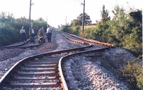
Compression failures from the Aug. 17 earthquake shifted a section of the railroad above. Curtesy of the Istanbul Technical University. |
Christina Reed
Geotimes
By early August, seven states and the District of Columbia had declared advisories, warnings or emergencies. Agriculture was hit hard as plants shriveled in the dry soil. Public water suppliers noted dramatic decreases in the levels of their reservoirs and feared they might not meet essential demands if the drought continued into the fall and winter. Geoscientists at the U.S. Geological Survey (USGS), state geological surveys, and interstate water commissions monitored the droughts effects. They predicted future availability of water and implications of the water shortage, and developed policies for minimizing the droughts impact on the environment and peoples lives.
The USGS played several key roles during the drought. According to Chief Hydrologist Bob Hirsch, the USGS supplied information about water supplies of streams, reservoirs, and groundwater, and about potential impacts on water quality and aquatic habitats. With this information, state and local policy-makers could anticipate the droughts severity and react quickly. The survey kept the media and Congress informed and provided findings that helped federal agencies plan drought relief efforts.
The USGS started streamgaging in 1889 under its second director, John Wesley Powell. This summer the survey monitored the drought using 7,000 streamgages, of which 4,000 are equipped with satellite telemetry for real-time data access over the Internet. USGS streamgages and groundwater observation wells showed the drought, which began nearly three years ago, created near-record low flows in more than three-quarters of the regions streams and rivers, as well as a dramatic reduction in groundwater levels.
A major impact of the drought was saltwater encroachment into eastern freshwater systems. As freshwater levels dropped, saltwater crept into the Chesapeake and Delaware Bays and moved into the lower Hudson River, affecting the ecologies of these waterways.
State surveys corroborated their own findings on water quantity and quality, along with USGS data, to advise state and local officials on drought policy. All the things we do in geology ... are being applied intensively right now, Robert Jordan, director of the Delaware Geological Survey, said in August.
With no immediate end to the drought in sight as the summer ended, the concerns of geoscientists at the USGS, state surveys and interstate commissions did not fade with the fall. Statistically, September and October are our dry months, Jordan said. This is not one event. It took a long time to get into this situation, and it will take a long time to get out.
Althea Cawley-Murphree
Geotimes contributing writer
The awards total at least $50,000 and individual grants range from $500
to $3,000 and are intended to fund specific thesis research expenses. Application
forms may be obtained from Chair, SEG Student Research Grants, 5808 South
Rapp Street, Suite 209, Littleton, Colo., 80120 USA. Phone: (303)797-0332;
Fax: (303)797-0417; E-mail: <socecongeol@csn.net>.
Forms are also available on the Web: <http://www.segweb.org>.
Applications must be postmarked by Feb. 1, 2000, and awards will be announced
by April 15, 2000.
 |
Geotimes Home | AGI Home | Information Services | Geoscience Education | Public Policy | Programs | Publications | Careers |