
Around Mount Rainier
 Mount
Rainier, a famous icon of the Pacific Northwest, draws about 2 million visitors
a year. The stratovolcano has not erupted since a few small events were recorded
in the early 1800s. But numerous lahars — mudflows on the slope of a volcano
triggered by various events including the sudden release of glacial meltwater
— continue to reshape the landscape, and the effects are visible throughout
the park today.
Mount
Rainier, a famous icon of the Pacific Northwest, draws about 2 million visitors
a year. The stratovolcano has not erupted since a few small events were recorded
in the early 1800s. But numerous lahars — mudflows on the slope of a volcano
triggered by various events including the sudden release of glacial meltwater
— continue to reshape the landscape, and the effects are visible throughout
the park today.
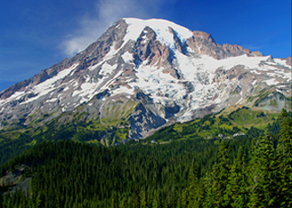
Regions that surround Mount Rainier shed much of their snow in the summer months, revealing a lush garden of trees sufficient to hide the Paradise parking lot (middle). Millions of visitors flock to the national park year-round to hike among its many glaciers. Photo courtesy of Kathryn Hansen.
Most visitors drive the kilometers of winding roads, which is an efficient way to get a feel for Mount Rainier National Park, as well as an up-close view of the majestic volcano. Backpacking, hiking and biking are also options that will take you away from the crowds and closer to Rainier's grandeur.
The best entrance when driving into the park depends on the time of year. Between May and November, you can enter from the northeast side at the White River Entrance Station. But this entrance closes in the winter due to snow conditions associated with its 1,067-meter (3,500-foot) elevation. You can enter any time of year from the southwest side at the Nisqually entrance, which is 456 meters lower and framed with a giant cedar log gate constructed in 1911. Both options eventually connect, and exist as endpoints to the main thoroughfare of the park. Grab a detailed park map online or at any entrance or visitor center.
If you drive in from Nisqually, turn left off of the Nisqually-Longmire Road onto Westside Road. A few kilometers down this fork at Dry Creek, you will find trailheads for several scenic hikes. Shortly beyond this point, recurring floods and rockfalls have permanently closed the road, but make for interesting viewing.
 Back
on the Nisqually-Longmire Road, look for signs for Kautz Creek. The creek flows
from Kautz Glacier, which is the source of the largest lahar since the establishment
of the park in 1899. In October 1942, heavy rains triggered a flow from the
glacier that moved about 40 million cubic meters of sediment 9 kilometers downstream,
and buried the Nisqually-Longmire Road 9 meters deep in debris. From the road,
you can still see dead trees partially buried by the slide and boulders strewn
about.
Back
on the Nisqually-Longmire Road, look for signs for Kautz Creek. The creek flows
from Kautz Glacier, which is the source of the largest lahar since the establishment
of the park in 1899. In October 1942, heavy rains triggered a flow from the
glacier that moved about 40 million cubic meters of sediment 9 kilometers downstream,
and buried the Nisqually-Longmire Road 9 meters deep in debris. From the road,
you can still see dead trees partially buried by the slide and boulders strewn
about.
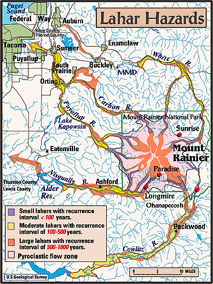
Small lahars, or mudflows often spawned from glacial outbursts, are not uncommon at Mount Rainier. But U.S. Geological Survey research suggests that a large lahar, occurring every 500 to 1,000 years, poses a threat to the surrounding populated lowlands (see Geotimes, April 2005). Evidence for lahars is visible throughout Mount Rainier National Park. Image courtesy of USGS.
Next, stop at the Longmire Historic District, which housed the original park
headquarters established in 1916. Here you can take a break to browse the Longmire
Museum and learn about the park's geology and landscape and the history of Native
Americans who inhabited the area. If prepared and extra ambitious, you can also
pick up your wilderness or climbing permit here. Otherwise, grab a bite to eat
or reserve lodging at the National Park Inn. If camping rather than lodging
suits your style, just east of Longmire is Cougar Rock Campground and a picnic
area, open from May to early October.
Even if your trail ends at Longmire, drive a short 6 kilometers more to see
Christine Falls. This is a favorite spot for photographers to take long exposures
of the water as it plummets below an old stone bridge.
Another bridge past Longmire, appropriately named Glacier Bridge, affords views
of the Nisqually Glacier. The glacier has advanced and retreated significantly
three times since 1965 and has thinned by about 16 meters since 1985. The current
retreat, however, is thought to be slowing. Also, look for a shelf of boulders
deposited by lahars that originated from glacial outbursts. Such debris flows
destroyed a 1930s-era bridge, and the remains of the foundation are still visible
here.
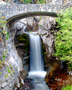
Christine Falls is just one place along
the Nisqually-Longmire Road worthy of stopping to snap a picture. In winter
months, snow and ice add to its appeal. Photo courtesy of Kathryn Hansen.
Perhaps one of the most popular destinations in the park is Paradise, located
about 18 kilometers past Longmire. From May to October, stop by the Paradise
Inn and restaurant, or the Jackson Memorial Visitor Center with guided interpretive
programs and a gift shop. The main attraction of Paradise, however, is its many
trails. For a short hike, try out the Nisqually Vista Trail, which is 2 kilometers
and shows off superb views of the mountain and Nisqually Glacier. A longer option
is an 8-kilometer-roundtrip hike on the Skyline Trail that takes you even closer
to the glacier.
Sunrise is the second most visited site at Mount Rainier National Park and also
boasts the highest elevation you can reach in your car, at 1,950 meters. This
area is located on the east side of the park and can be reached by continuing
along the same road that leads to Paradise. But if this is the only planned
stop, it would be quicker to enter through the east side of the park at White
River.
Many trails also leave from this location. The Palisades Lake Trail winds for
11 kilometers, ending at a lake and a towering rock formation for which the
trail was named. The Burroughs Mountain Trail, Mount Fremont Lookout Trail,
Shadow Lake Trail and Sourdough Ridge Trail also leave from here.
Not far away is the White River Campground, where you can camp or pick up the
short trail that leads to close views of Emmons Glacier, which according to
the U.S. Geological Survey remains the glacier with the largest area in the
contiguous United States at 11 square miles. In 1963, a rockfall from Little
Tahoma Peak covered the lower glacier with debris. The rocks have insulated
the ice from melting and it continues to advance today.
The northwest section of the park is not connected by the main road, but it
is worth the effort of driving around to the Carbon River entrance to reach
the trailhead for Carbon Glacier Trail, which is also a beginning point of the
150-kilometer Wonderland Trail that encircles Mount Rainier. Reservations and
careful planning are required if you want to backpack the entire 150 kilometers,
but the first 11 kilometers along the Carbon Glacier Trail offer much to see
in a day trip. A suspension bridge crosses the Carbon River and leads to the
mouth of Carbon Glacier — the glacier at the lowest elevation in the lower
48 states.
Visit Mount Ranier any time of year; summer is the best time to hike, but winter
conditions are perfect for snowshoeing or cross-country skiing. Just be certain
to call ahead, and ask a park ranger about trail conditions and road closures.
Kathryn Hansen
Links:
Detailed
maps from the National Park Service
Hiking
trail descriptions for Mount Rainier National Park
"Paths
of Destruction: The Hidden Threat at Mount Rainier" Geotimes,
April 2004
USGS
map of Mount Rainier glaciers
The
National Park Service Reservation Center
Learning
to live with volcanic risk from lahars
 |
Geotimes Home | AGI Home | Information Services | Geoscience Education | Public Policy | Programs | Publications | Careers |