
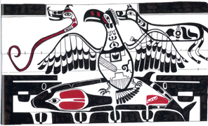
 A
Native American tale tells of an epic battle between the supernatural Thunderbird
and Whale in the waters off the coast of the Pacific Northwest. After the chivalrous
Thunderbird finally succeeded in catching Whale in its talons, it returned to
its nest, where another fight commenced. Then, “there were … shaking,
jumping up and trembling of the earth beneath, and a rolling up of the great waters.”
A
Native American tale tells of an epic battle between the supernatural Thunderbird
and Whale in the waters off the coast of the Pacific Northwest. After the chivalrous
Thunderbird finally succeeded in catching Whale in its talons, it returned to
its nest, where another fight commenced. Then, “there were … shaking,
jumping up and trembling of the earth beneath, and a rolling up of the great waters.”
 Ever
since geologists in the late 1980s discovered that the Cascadia subduction zone
in the Pacific Northwest could generate magnitude-9-plus earthquakes, they have
sought a better understanding of the history and mechanics of the 1,200-kilometer-long
fault. Now, two new studies suggest that Cascadia is more complex, but also
perhaps has a pattern of movement that could help planners and emergency management
personnel better prepare for the next large earthquake.
Ever
since geologists in the late 1980s discovered that the Cascadia subduction zone
in the Pacific Northwest could generate magnitude-9-plus earthquakes, they have
sought a better understanding of the history and mechanics of the 1,200-kilometer-long
fault. Now, two new studies suggest that Cascadia is more complex, but also
perhaps has a pattern of movement that could help planners and emergency management
personnel better prepare for the next large earthquake.
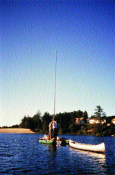
A low-budget coring platform (plywood
bridging two canoes with additional buoyancy provided by 55-gallon drums) was
the setting for retrieval of multiple 6-meter-long cores from the bottom of
Bradley Lake on the southern Oregon coastal plain. The cores revealed a sedimentary
record of multiple tsunamis that have have hit the Oregon coast over the last
4,600 years, generated by earthquakes on the Cascadia subduction zone. Courtesy
of Alan R. Nelson.
When studying Cascadia, Harvey Kelsey, a geologist at Humboldt State University
in California, and colleagues began with Bradley Lake, a small lake about 500
meters inland on the southern Oregon coast. They chose Bradley, after a year-long
reconnaissance of lakes from Washington to California, because for the past
7,000 years, it has recorded Cascadia-generated tsunamis, but not farther-traveling
ones, as the lake is too high and too far inland. What they found there were
two major observations: “One is that the entire margin of Cascadia does
not move during an earthquake, and second is that tsunamis occur in a cluster-gap-cluster
pattern,” Kelsey says.
Reporting in the July/August Geological Society of America Bulletin,
they determined that tsunamis entered the lake on average once every 390 years,
whereas thelocal record of Cascadia earthquakes near Bradley shows an interval
of one every 500 years. “If the entire Cascadia margin moved, then we would
see a one-to-one match,” Kelsey says.
The research team also assembled a detailed record of when tsunamis hit Bradley.
The data reveal that tsunamis occur in 250- to 400-year clusters followed by
gaps of 700 to 1,300 years, with the earthquake in 1700 possibly beginning a
new cluster of quakes. On Jan. 26, 1700, a magnitude-9.0 earthquake ruptured
the entire length of the subduction zone and generated tsunami deposits from
California to Canada (see story, above). This “megathrust”
event was the last major movement on the Cascadia fault system.
“Their work is meticulous. They have put together an excellent standard
for dating along the Oregon coast,” says Brian Atwater, a U.S. Geological
Survey (USGS) geologist at the University of Washington who specializes in Cascadia
tsunami research. Previously, geologists thought that the 1700 event, which
broke along the entire margin, represented the “norm,” Atwater says,
but Kelsey’s team’s work “brings back to light earlier observations
that Cascadia has a variable rupture mode. This is a really important finding.”
In another study in the July/August Geological Society of America Bulletin,
a team led by Andrea Hawkes, a graduate student at University of Pennsylvania,
proposed a potential method to give advance warning of large earthquakes in
the Cascadia zone. This study is the first to look at two widely spaced megathrust
events.
The team analyzed fossils of microorganisms that are highly sensitive to changes
in water chemistry and thus record minor changes in land level. These fossils
are proxies for small-scale land sinking or uplift produced by smaller earthquakes
that appear to precede large-scale movements, such as on the Cascadia fault.
Although the two sites differ in sedimentary records, both clearly record a
distinct sequence of precursor events — subsidence, deposition of tsunami-generated
sediments and uplift — that occur three to 10 years prior to a megathrust
movement along the Cascadia fault. “The most beneficial aspect of our study
is that it gives modelers better variables with fewer errors,” Hawkes says.
She is now looking at additional marshes along the Oregon coast to better refine
her data.
“These precursors are interesting observations, but there is still a lot
of uncertainty,” says Tom Brocher, co-project chief of the Pacific Northwest
Earthquake Hazard Investigations for USGS. “They may be good alerts for
long-range concerns, such as building safety, but not necessarily for a megathrust
movement,” he says. “Our records are too short in time to know exactly
what this data means.”
David B. Williams
Geotimes contributing writer
 |
Geotimes Home | AGI Home | Information Services | Geoscience Education | Public Policy | Programs | Publications | Careers |