Web Extra
Monday, September 11, 2006
Mayon Volcano eruption
slows
Fewer
seismic events and lessened ground deformation indicate that the ongoing
eruption of Mayon Volcano, the Philippines' most active volcano, is finally
slowing down, according to a Sept. 9 bulletin from the Philippine
Institute of Volcanology and Seismology (PHIVOLCS). The slowdown follows
almost two months of volcanic unrest for the mountain, which is located
on the Philippine island of Luzon.
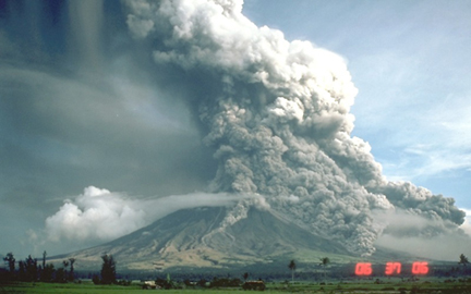
During a 1984 eruption, pyroclastic
flows cascaded down the flanks of Mayon Volcano. That eruption and the
more recent activity, now slowing, mark only a few of the mountain's long
history of eruptive events. Images are courtesy of the U.S. Geological
Survey.
On July 14, Mayon started a "mild" eruption, as pieces of lava
tumbled midway down the mountain's flanks, and the number of earthquakes
and amount of sulfur dioxide emissions increased, according to PHIVOLCS.
As a result, the institute increased the alert level to 3 (out of a possible
maximum 5) implying an "increased tendency towards eruption,"
and advised that people stay at least 6 kilometers away from the mountain.
Then, on Aug. 7, the institute raised the alert level to 4, indicating
an eminent eruption, as six small events between 7:08 a.m. and 7:48 a.m.
spewed ash up to only 800 meters above Mayon's summit.
The
large explosive eruption that some scientists expected never happened,
however, and the number of volcanic earthquakes has been dropping. Scientists
detected 31 events on Sept. 2, followed by nine events on Sept. 3 and
only two on Saturday, according to PHIVOLCS bulletins on those days. Still,
despite the slowdown, Mayon remains under an alert level 4, and areas
8 kilometers from the mountain are considered a hazardous danger zone.
Mayon Volcano is located on the
Philippine island of Luzon, at the junction of two tectonic plates. Mayon
is the most active of the region's major volcanoes.
Beyond the hazardous zone, about 30,000 people remain in evacuation centers,
where they have been living for more than a month, according to a Sept.
8 Agence France-Presse report. So far, there is no
word as to when evacuees can return home, the report says.
Such unrest is nothing new for Mayon, which rises 2,462 meters above sea
level at the boundary of the converging Philippine and Eurasian plates.
Records dating back to 1616 indicate that eruptive events, producing pyroclastic
flows and mudflows, have been a regular occurrence for Mayon, according
to the Smithsonian Institution's Global Volcanism Program.
The last major eruption to warrant an alert level 5 took place on July
26, 2001, when an explosive plume reached 10 kilometers above the summit,
and pyroclastic flows headed toward surrounding cities. The most deadly
eruption struck in 1814, when lava from Mayon buried the town of Cagsawa,
killing 1,200 people, according to the Global Volcanism Program.


 Subscribe

 Fewer
seismic events and lessened ground deformation indicate that the ongoing
eruption of Mayon Volcano, the Philippines' most active volcano, is finally
slowing down, according to a Sept. 9 bulletin from the
Fewer
seismic events and lessened ground deformation indicate that the ongoing
eruption of Mayon Volcano, the Philippines' most active volcano, is finally
slowing down, according to a Sept. 9 bulletin from the 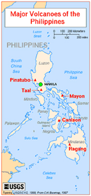 The
large explosive eruption that some scientists expected never happened,
however, and the number of volcanic earthquakes has been dropping. Scientists
detected 31 events on Sept. 2, followed by nine events on Sept. 3 and
only two on Saturday, according to PHIVOLCS bulletins on those days. Still,
despite the slowdown, Mayon remains under an alert level 4, and areas
8 kilometers from the mountain are considered a hazardous danger zone.
The
large explosive eruption that some scientists expected never happened,
however, and the number of volcanic earthquakes has been dropping. Scientists
detected 31 events on Sept. 2, followed by nine events on Sept. 3 and
only two on Saturday, according to PHIVOLCS bulletins on those days. Still,
despite the slowdown, Mayon remains under an alert level 4, and areas
8 kilometers from the mountain are considered a hazardous danger zone.