
|
 Subscribe

Travels in Geology September 2007 posted September 27, 2007
Madeira: More than just wine
Davide Baioni
 Marcial Fernandes: Turismo da Madeira |
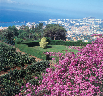
| The botanical gardens in Funchal, Madeira, offer a terrific view of the capital city. |
With rolling green hills surrounded by frothy blue ocean, the island of Madeira lies in the middle of the Atlantic Ocean, less than a thousand kilometers southwest of Lisbon, Portugal, and 600 kilometers from the coast of Morocco. Perhaps best known for its namesake soft, fortified wine, people might not realize that this volcanic island is also home to stunning geological formations, which host some of the world’s foremost flowers year-round. In fact, Madeira is often called “the island of the flowers.” Here, iridescent waterfalls crash over the treacherously narrow roads, dreamlike flowers glimmer through a mist of rainbows and exotic fruits dangle from primeval tree limbs; the flora is so exotic it almost seems contrived.
For these reasons, Madeira is a very popular European tourist destination and cruise ships often stop at the capital, Funchal, during trips from the Caribbean to the Mediterranean, or from the Mediterranean to northern Europe. An international airport provides an easy connection between the island and mainland Europe. To get there from the United States, though, you’ll have to fly to Europe first. The cheapest way may be to fly to Lisbon, then buy a separate flight to Madeira.
 Davide Baioni |
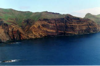
| Ponta de São Lourenço, a narrow, curved peninsula on the eastern side of the island of Madeira, offers a look at the island's volcanic history. |
The island is part of a small volcanic archipelago of the same name in the Atlantic Ocean, first known to the Romans and then rediscovered by Portuguese sailors around 1419. Of the island chain, Madeira is the largest and most populated island.
Miocene- to Holocene-aged volcanoes formed the islands when the Eurasian Plate moved over a hotspot in the same way the islands of Hawaii formed. The lava that formed Madeira reached above the ocean’s surface about 5.2 million years ago.
Madeira is well-known for its pristine landscape and perfect climate — temperatures average between 16 degrees Celsius and 25 degrees Celsius, or roughly 60 to 80 degrees Fahrenheit. Anthurium, orchids, birds of paradise, variegated lilies, protea and other flowers bloom everywhere.
Landing on Madeira, you’ll probably first note the striking scenery of Ponta de São Lourenço, a narrow, irregular and curved peninsula on the eastern side of the island; it is a textbook example of volcanic cinder cones that have since been shaped by erosion from the sea. Approached by ship, Madeira offers an unforgettable look at Funchal: sharp mountains dropping straight into the valleys, dense vegetation growing on the mountain terraces, split by steep cliffs and dotted with white houses.
 Marcial Fernandes: Turismo da Madeira |
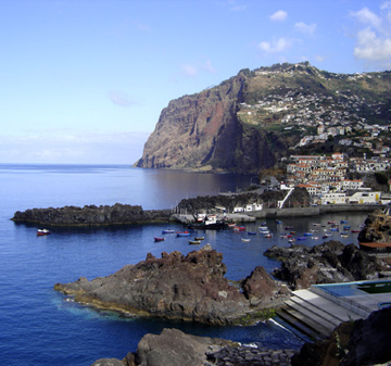
| Câmara do Lobos is a small fishing village not far from Funchal that is known for its specialty drink, the poncha. It is also a great place to stop along your driving tour of Madeira, as several good hikes leave from here. |
Funchal, the capital of Madeira, is located in a unique area; what were once tall cinder cones now form an amphitheater surrounding the city, thanks to millennia of erosion. The botanical gardens offer a splendid view of Funchal Bay and the contrasting colors of the surrounding countryside. The gardens contain more than 2,000 plants from around the world, a tropical birds exhibit and an outdoor cafe. The orchid collection is at its best from December to April. Funchal also offers views of one of the best and thickest lava flows of the main volcanic stage. The lava flowed southeast and cooled as it was flowing, leaving behind distorted column-like jointing.
Spend a day in Funchal and then head out to explore the rest of the island. You can either do an organized shore excursion (organized through a cruise ship, or through hotels or tourism agencies in the capital), or rent a car. However, be aware that many of the roads are narrow and difficult to navigate, so driving yourself might be more exciting than you want. If you do drive, get a good tourist map. To see the widest variety of the geomorphological changes across the island and to get the most out of your trip, split the island into west, central and east circular driving tours, whether with a guide or on your own.
First, head west toward Câmara do Lobos, a small fishing village known for its special drink, called poncha, a mixture of lemon juice, honey and sugarcane spirits. The two most important beaches on the island are found bordering the village on each side. Furthermore, just outside the village, you’ll find two of the neatest sites on the island: Cabo Girão and Curral das Freiras. Cabo Girão, two kilometers from Câmara do Lobos, rises more than 560 meters above the sea and is the third-steepest cliff in Europe. It was formed by a succession of overlapping volcanoes and is a good place to start a hike, so long as you’re not acrophobic. Once you’re done exploring the cliff, get back in the car and head up the road a bit to Curral das Freiras, a small town nestled in a valley floor between two mountains nearly perpendicular to the valley floor. The valley is thought to have either formed when a caldera collapsed, or from erosion. Curral das Freiras, which translates to “Nuns’ Valley,” earned its name in the 1500s when Funchal was attacked by pirates and some nuns escaped to this valley and set up a new convent.
 Marcial Fernandes: Turismo da Madeira |
| Curral das Freiras is a small town nestled in a valley floor that is thought to have either formed when a caldera collapsed or from erosion. |
After your trip through the valley, head up the road toward the village of Ribeira Brava. On the way, you’ll pass through a luxuriant “laurisilva” forest (a specific type of subtropical forest) that was named a World Heritage Site by UNESCO in 1999. After driving for an hour through winding, sharp basalt walls, and just when you start to wonder if you are lost, you find yourself at the Boca da Encumeada road junction. Drive just a few hundred meters farther and you will find a viewpoint where you can stop. From here, you can see both sides of the island. The scenery is breathtaking.
Continuing on your drive, you will soon reach the Paul da Serra plateau. This alpine plateau (approximately 16 kilometers long and six kilometers wide) marks the highest point of the western part of the island. The clastic deposits that make up the plateau are red or red-brown in color, and the absence of any kind of vegetation gives it the feel of a Martian landscape. Here you can see a distinct scoria, or cinder, cone, called Pico Urze, at the end of the plateau. It is the southernmost of a line of three scoria cones cutting across the landscape. You can easily see the vertical dykes that travel across the red weathered tuff and radiate out from the top, where a volcanic plug is visible.
At this point, the road will start to travel down toward the north coast, characterized by steep cliffs interspersed by valleys containing younger lava flows. The lava flowed down out to sea at the coastal village of Porto Moniz, where you can see an eroded ash cone called Ilhèu Mole (Soft Island) where the flow of lava stopped. This is a very popular tourist attraction, thanks to the concrete ledges that have been added to form rock pools for swimming.
Following the coast road eastward, you will find the village of Seixal with its vineyards, a reminder that Madeira is also renowned for its wine that was responsible for spreading its namesake and the taste of its home island throughout the world. Wine is a way of life here. If you stop to ask for directions on a drive through the countryside, you will, without fail, be offered a glass of wine.
On the drive back to Funchal, make sure to stop at the waterfall called “The Bride’s Veil” and at the village of São Vicente, which has lava tube caves that are open to visitors. São Vicente achieved worldwide fame thanks to Charles Lyell who visited the island in 1852 and used the outcrop of early-Pliocene-aged reef limestone next to the village’s church, approximately 400 meters above the sea, to explain Madeira’s origin.
Once you get back in Funchal, take a relaxing walk in the old town center and find a typical Madeiran restaurant, where you can spend your evening enjoying a good dinner and a good glass of wine while contemplating all the geology you’ve just seen.
Baioni is a graduate student at the Università degli studi di Urbino "Carlo Bo" in Urbino, Italy, working on his doctorate in geology. He is also an avid traveler. Baioni dedicates this article to Piia Elina Askolin.
Links:
Travel Guides:
Madeira Regional Tourism Department
www.madeira-web.com
www.madeira-island.com
www.madeira-tourist.com
Back to top

