
|
Feature When Levees Fail Megan Sever Levees by the numbers Print Exclusive How fast is New Orleans sinking?
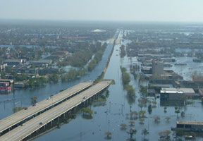
When Hurricane Katrina struck, many people were surprised at how poorly New Orleans’ levee system performed in the face of the Category-3 storm. The levee failure resulted in the flooding of 80 percent of the city. Photograph is courtesy of Louisiana Department of Environmental Quality. Since Katrina struck, however, people around the country, and the world, have learned that levees — both natural and human-made — are everywhere, and, they can fail anywhere, leading to flooding. The Dutch have relied on levees for 1,000 years, people along the Mississippi River from Minnesota to New Orleans have relied on them for 200 years, and people in Northern and Central California have relied on them for 150 years. Many of the levees in the United States were built more than a century ago to protect farmland, and have been negligibly, if at all, maintained. Furthermore, people keep moving into floodplains and into harm’s way. The problem, says Jeff Mount, a geologist at the University of California in Davis, is that people are asking an antiquated system to do more than it was ever designed to do. And when that happens, disaster can strike. For New Orleans, such a lesson came too late, but the city can still plan for the future. Elsewhere, in Central California, for example, people worry about what might happen down the road, if politicians and engineers do not act soon to upgrade the state’s vulnerable levee system. Both locales are learning from the Netherlands, which has one of the world’s most extensive and effective levee systems. Katrina perspective In May and June, two independent teams released studies about the levee failure, which both teams are calling the single most costly catastrophic failure of an engineered system in history. The reports — one by the Interagency Performance Evaluation Task Force (IPET) and commissioned by the U.S. Army Corps of Engineers, and another by a volunteer group of academics led by the University of California in Berkeley — looked at what happened, how and why it happened, and how to avoid a repeat of Katrina’s devastation. “The two reports are very well-aligned, especially in our reviews of the engineering mechanisms that broke down,” says Robert Bea, an engineer who co-led the Berkeley team. The take-home message of both reports is that “this was very, very definitely a human-caused catastrophe.” Although some flooding was bound to happen given the size of the storm and the design of the levee system, much of the “carnage” resulted from the inadequacies of the system, he says. According to the IPET team, two-thirds of the flooding and one-half of the economic losses can be attributed directly to water flowing through the levee breaches. New Orleans is surrounded by 580 kilometers (360 miles) of levees built at various points over the past 150 years. Investigations, involving direct observations, as well as numerical and physical modeling, revealed that about 97 kilometers of the levees failed, says Tarek Abdoun, a civil engineer at Rensselaer Polytechnic Institute in Troy, N.Y., and a member of the IPET team. Some of the levees failed more catastrophically than others, he says. The team identified half a dozen different failure mechanisms, Abdoun says. Furthermore, some of the levees that failed were not overtopped by the storm surge, as widely reported in the days and weeks following the hurricane. Instead, these levees failed from within, says Peter Nicholson, an engineer at the University of Hawaii in Manoa and a member of a team that reviewed the IPET’s process and report. Some levees failed because the underlying support was too weak for the load put on them, Nicholson says. Water pushed sideways against the walls until it overcame the strength of the soils. Other levees merely eroded away like sandcastles under ocean waves. Levees also failed due to internal erosion and seepage, he says — water seeping through the soil foundations beneath the levees scoured out bigger holes, through which more water passed. An even bigger problem, he adds, was “overtopping scour,” where the water washed away the soil behind concrete floodwalls, allowing the floodwalls to topple over. These failures were related to the type of soil used in the designs of the levees or the soils on which they were constructed, Nicholson says — the Corps used sand, shells and soils dredged up from the bottom of the canals to build up the levees. Such soils are erosion-prone and compactable. The combination of the weight of the levees and the compressible soils on which they were built made the levee foundations sink, causing their crests to drop below design levels and fail under extreme circumstances, he says. The IPET and Berkeley teams both found that most of the levee failures were as much related to the original levee and floodwall designs as the storm itself, and thus could have been avoided, Nicholson says. Furthermore, he adds, many of the levees and floodwalls were not constructed even to the level to which they were designed. The levees were designed to withstand a Category-3 hurricane, which is inadequate protection for a city that lies mostly below sea level and is still sinking, he says. “The designs didn’t provide enough for the safety of critical infrastructure,” he says, and they still don’t.
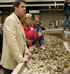
In January, U.S. Sen. David Vitter (R-La.), Louisiana Transportation Secretary Johnny Bradberry and Sen. Mary Landrieu (D-La.) (from left to right) toured WL Delft Hydraulics in the Netherlands to learn about the Dutch flood protection system. Photograph is courtesy of U.S. Senate. California worries Central California’s levees protect Sacramento, Stockton and other cities, as well as much of the nation’s agriculture and the water supply of 23 million Californians, including most of Southern California. In the event of a major breach, these areas could be up to 5 meters underwater, and the water supply to Southern California could be knocked out for a period of years, Bea says. California does not face a hurricane risk like the Gulf Coast, but it has its own natural hazards to worry about, including seasonal flooding of the Sacramento and San Joaquin river systems, which drain the steep Sierra Nevada and meet in a series of low-lying islands in the delta near San Francisco Bay, says Mount of Davis. Much of the delta is up to 8 meters below sea level — similar to New Orleans, he says. Additionally, seasonal flooding has gotten worse over the past few years and is expected to worsen further with climate change, he says. And then there’s the earthquake issue: Studies have suggested that a magnitude-6 or -7 earthquake within 10 kilometers of the delta could cause breaching of 50 to 90 percent of the levee system, Bea says. Such a breach would devastate the water supply system. No one really knows how many kilometers of levees exist in California, Mount says. DWR has been trying to get a rough count, and has so far measured 22,500 kilometers of levees statewide, Harder says. The ones in worst shape, however, are primarily in the Central Valley. Farmers built most of the levees outside of and within the delta around the time of the California Gold Rush, 150 years ago, when they drained the marshes to reclaim the fertile land for agriculture, Harder says. They usually dredged the land and scoured out the river bottoms and deposited that soil on top of the levees to make them taller, he says. That process led to the levees being composed of tree stumps, vegetation and poor soils — materials “we would completely reject in building levees today,” he says. And, like New Orleans, the levees and the surrounding landscape in the delta are subsiding due to compaction of the organic soils. The levees were designed to “fail” episodically, in that floods were allowed to happen when “things got really bad,” Mount says. Over time, as the land around the levees, and the levees themselves, have subsided, people have just added more dirt on top. Today, he says, these same levees “are being asked to protect not just the farmland, but also the water supply of 23 million people, and sprawling urban centers.” Although the Corps has been trying to survey many of the levees every year, especially those that are protecting the water supply, “we have no idea what the situation is” in most levees, Mount says. Most likely, he says, if engineers surveyed them all, they would discover that these systems are in dire straits. “We know there are problems with seepage, underseepage, liquefaction, subsidence, and then there’s this wildcard — beavers and rodents that are building 2-meter-wide dens in the levees underwater, so we don’t even know where they are,” he says. Central and Northern California’s levees are indeed “very weak, very marginal,” Harder says. Additionally, most areas throughout this region have less than 100-year flood protection, he says, referring to the statistical calculation of the maximum level of floodwater that is expected to be exceeded on average once every 100 years. California’s capital, Sacramento, is only protected to an 80-year flood level and in fact, flooded this past winter. “In the Central Valley, including Sacramento, we could have flooding 15 feet (5 meters) deep — it would look just like New Orleans,” Harder says. Scientists have been calling for the system to be fixed for decades, Mount says, but until Katrina struck New Orleans, their calls largely fell on deaf ears. The issue became more urgent last winter, as many areas flooded in winter and spring storms, and a Corps survey revealed that more than two dozen levees could fail at any moment. Katrina “brought the issue home,” Bea says, but “most people look at New Orleans and say ‘it’s fixed, or getting there at least,’ and they move on.” As people go back to their normal lives, he says, “you can almost see the worries receding with the floodwaters.” Dutch experience
Much of Holland lies below sea level or is vulnerable to floods from the three large rivers that run through it. The arms of the Maeslant storm surge barrier near Rotterdam, as seen here, are each 240 meters long — the barrier is almost as long as the Eiffel Tower. The arms of the barrier close, completely shutting down the waterway, when water levels reach 3 meters above normal levels. Photograph is courtesy of Delta Works/Ministerie van Verkeer en Waterstaat - Rijkwaterstaat - Adviesdienst Geo-Informatie en ICT (AGI). Finally, Battjes says, all three regions have a common “cyclic” history of floods, followed by residents building new hydraulic “works” and higher dikes, and then watching the cycle repeat itself. The Dutch acquired their hydraulic expertise out of necessity and out of disaster, he says, as seems to be happening in the United States now following Katrina. The Netherlands, however, is a bit ahead of the curve, as it has had many more wake-up calls through history, Battjes says. Most recently, on Feb. 1, 1953, a high-tide storm from the North Sea breached a number of sea dikes in the southwestern part of the country, inundating or sweeping away 47,000 homes and buildings, and killing around 1,900 people. Those floods, he says, changed the political, psychological and environmental landscape of the country. The Dutch chose to enact the most extensive storm-surge protection project in world history. The multibillion-dollar Delta Works plan, which took 40 years to build, involved closing off almost all of the inlets and estuaries in the southwest by a series of dams and storm-surge barriers with massive floodgates to prevent North Sea storm surges from entering. Delta Works protects much of the country for up to a 10,000-year-storm, with other parts protected to a 2,500-year standard. “And we still don’t think it is good enough, in view of increased population and infrastructure,” Battjes says, so the scientists and politicians are going back to the drawing boards to create a new, better plan. “In this respect, Katrina served as a wake-up call in Holland, marking the extreme importance of adequate flood protection in populated areas,” he says. One new plan, called Room for the River, will include a full-scale redesign of the way the country thinks about and manages its rivers, Battjes says. Instead of building ever higher dikes to accommodate increased design discharges, the plan will allow the rivers to flood in designated areas when the rivers are dangerously high. Most politicians favor the plan, but considering it involves flooding private land, many landowners are against it, he says, so only time will tell how practical it is. Still, he says, the plan is a good example of where Holland is heading: “This option is intended to allow room for future changes” in climate, geography and populations, “and it may cost more now, but it’s better for the future.” That mentality needs to be the future of flood management, he says — realizing that people cannot engineer everything, so they have to build as strong a defense as possible, but it also needs to be adaptable. Sustainable steps In addition to repairing the levees and floodwalls, it installed floodgates, similar to those the Dutch use, and temporary pumps to prevent the storm surge from entering canals during a hurricane, as happened during Katrina. “It’s much better engineered,” Nicholson says, but there’s more to be done. In California, alongside the Corps, DWR is now working on the 29 “critical” levee sites, says Oscar Hidalgo with DWR. Those sites need to be repaired by Nov. 1, when the next winter storm season begins in California. “We’re not building new levees or making them better, we’re merely reinforcing them — it’s like triage,” he says. As the Dutch move ahead with their plans, some lessons can be learned, even though their system is not necessarily the best for us, Bea says. The primary lesson Americans can learn from the Dutch is to cooperate with nature — “it’s mandatory, not voluntary,” he says. The only sustainable system, he says, is one that is “financible,” in step with nature and people, and adaptable. The IPET report called for a need to build in “adaptive capabilities” — to plan for subsidence, changing population demographics, changing patterns of hurricane intensity and frequency, and rising sea levels. Such sustainability should be included in California’s system as well, Harder says. “We can raise the height and width of the levees, build new ones near the old ones, install ‘armor’ to prevent erosion,” but, he says, “we also need to make good land-use decisions.” Key to the futures of both New Orleans and California might be limiting growth and development, and restoring some of the natural wetlands and marshes, Harder says. But realistically, he says, the regions have to have good evacuation plans and make sure that everyone has flood insurance. On a national level, “we need to undertake a massive, nationwide levee inventory,” Nicholson says, such as was done for dams with the Dam Safety Act. Once engineers know what’s out there, they can start fixing the worst ones and working through them one at a time. “Levees are like roads: You don’t just put them there and neglect them, and leave them alone forever,” Abdoun says. “You need to regularly maintain and update them.” Neglect has been the status quo for too long, he says. And that’s when disaster strikes.
Sever is a staff writer for Geotimes. Links:
|
 |
Geotimes Home | AGI Home | Information Services | Geoscience Education | Public Policy | Programs | Publications | Careers |
 Subscribe

 When
Hurricane Katrina struck New Orleans and the Gulf Coast a year ago this
month, “levee” became a household word. Prior to the massive
levee failures and the devastation that followed, the only people who
were more than nominally familiar with the earthen embankments lived alongside
them.
When
Hurricane Katrina struck New Orleans and the Gulf Coast a year ago this
month, “levee” became a household word. Prior to the massive
levee failures and the devastation that followed, the only people who
were more than nominally familiar with the earthen embankments lived alongside
them.
 Although
the IPET team does not point fingers or “go after the social issues
within the hierarchy of the Corps and the funding and politics,”
Nicholson says (because IPET considered such issues beyond their scope),
the Berkeley team does address those “valid” concerns. “No
one group had a monopoly on the responsibility and liability here,”
Bea says. “On top of being an engineering failure, what happened
in New Orleans was a huge institutional and organizational failure,”
he says. But it’s not unfixable: The important thing to watch, he
says, is how the Corps, politicians and scientists move forward.
Although
the IPET team does not point fingers or “go after the social issues
within the hierarchy of the Corps and the funding and politics,”
Nicholson says (because IPET considered such issues beyond their scope),
the Berkeley team does address those “valid” concerns. “No
one group had a monopoly on the responsibility and liability here,”
Bea says. “On top of being an engineering failure, what happened
in New Orleans was a huge institutional and organizational failure,”
he says. But it’s not unfixable: The important thing to watch, he
says, is how the Corps, politicians and scientists move forward.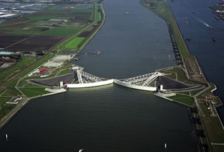 Similarly,
much of the Netherlands is reclaimed out of tidal marshes and swamps,
and is continuing to subside, Battjes says. And all three regions face
strong storms, with Central California and Holland facing strong winter
storms and New Orleans facing hurricanes, and the regions are facing increasing
challenges from climate change, Bea says.
Similarly,
much of the Netherlands is reclaimed out of tidal marshes and swamps,
and is continuing to subside, Battjes says. And all three regions face
strong storms, with Central California and Holland facing strong winter
storms and New Orleans facing hurricanes, and the regions are facing increasing
challenges from climate change, Bea says.