|
NEWS NOTES
Why China Quaked: A perfect seismic storm
 Courtesy of the Tectonics Observatory at Caltech |
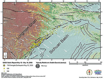
| The Longmen Shan Fault separates the Tibetan Plateau from the Sichuan Basin. |
The massive magnitude-7.9 earthquake that struck China’s Sichuan province on May 12, killing 70,000 people and injuring hundreds of thousands more, may have taken Chinese citizens by surprise, but some experts say a major seismic event in this region was only a matter of time.
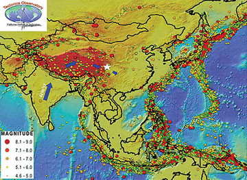
It doesn’t take a degree in geology to know that powerful tectonic forces underlie the immense Himalayan mountain range that neighbors the Sichuan province. These 8,000-meter-tall peaks started rising about 45 million years ago when the Indian subcontinent crashed into the Eurasian Plate. Today India continues to grind north at a geologically swift pace of about five centimeters a year, uplifting the Tibetan Plateau even higher and generating scores of powerful earthquakes throughout central Asia.
The Sichuan quake released an enormous amount of pent-up energy along the Longmen Shan Fault, which separates the 6,500-meter-high Tibetan Plateau from the much lower Sichuan Basin. This fracture in Earth’s crust is a thrust fault, where compressional forces push one side of the fault — in this case the plateau — up and over the basin.
On May 12, the 250-kilometer-long fault line ruptured in two places, according to Yuji Yagi, a seismologist at Tsukuba University in Japan. The first rupture uplifted a 100-kilometer-long section seven meters in 50 seconds, and then 10 seconds later, another section sheared four meters upward in a minute. The two consecutive ruptures made for an exceptionally long period of ground shaking, nearly two terrifying minutes. (Most earthquakes last just a few seconds.)
Although the duration of the quake certainly contributed to the severe structural damage in the region, the earthquake’s shallow focus, less than 10 kilometers belowground, played a larger destructive role, says Laurie Kovalenko from the Tectonic Observatory at Caltech in Pasadena, Calif. The short travel distance to the surface meant little energy was dissipated underground. “The amount of shaking correlates with rupture depth,” she says. “The closer the rupture is to the surface, the stronger the shaking.”
The shallow focus also meant that the seismic waves emanating from ground zero propagated through Earth’s uppermost crust where they can travel faster than in the deeper subsurface — as fast as 3.5 kilometers per second. This is why within minutes of the Sichuan shaking, tremors were reported thousands of kilometers away in Shanghai, Beijing and Thailand.
 Courtesy of the Tectonics Observatory at Caltech |
| Map showing the location of the May 12 Sichuan earthquake (white star) as well as the location of all earthquakes occurring between 1964 and 2004 with magnitudes between 4.6 and 9.0 (colored circles). |
Seismic waves can travel quickly and efficiently in this part of the world because very dense, hard rock underlies much of China and Eastern Asia, says Walter Mooney of the U.S. Geological Survey in Menlo Park, Calif. In the same way that light shoots through fiber optic cables without dissipating energy, seismic energy can travel far through China’s uniformly hard crust without losing power.
Much of the quake’s tragically high death toll was due to widespread structural failures. More than 80 percent of the buildings in heavily populated Beichuan County collapsed, trapping thousands of residents in the rubble. Subpar construction is partly to blame, but Jean-Phillipe Avouac of the Caltech Tectonic Observatory also points out that much of the Sichuan Basin is composed of loosely packed sediments shed from the plateau. This unstable ground amplified the shaking in many places, he says.
The steep topography and remote location of the Sichuan area greatly hindered rescue operations, adding to the death toll. Landslides blocking the mountain pass roads into the basin further complicated rescue efforts. Some of these slides intercepted rivers, creating hundreds of natural dams and so-called quake lakes. These unstable dams are a flood threat to towns downstream and Chinese authorities have been working since the quake to drain the lakes safely.
China is no stranger to earthquakes, but this latest quake has shaken the entire country. The horrendous death toll continues to rise. Thousands of aftershocks, some greater than 6.0 in magnitude, have repeatedly struck Sichuan and surrounding regions, further complicating the already difficult rescue and cleanup efforts. And geologists say that such aftershocks could continue for months.
Links:
Flood threat averted after China quake, Geotimes online, Web Extra, June 10, 2008
Aftershock warnings continue to shake up China, Geotimes online, Web Extra, May 21, 2008
Quake rocks central China, Geotimes online, Web Extra, May 12, 2008
News story on CNN.com
News story from Xinhua

 Subscribe


