
|
 Subscribe

Geophenomena
Heavy Hawaii spawns twin earthquakes
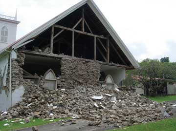 |
| The 150-year-old Kalahikiola Congregational Church in the Kohala District, at the northwestern corner of Hawaii’s Big Island, sustained severe structural damage from the October 2006 earthquakes. Photograph is by M. P. Poland, USGS Photos. |
Two back-to-back earthquakes that shook the big island of Hawaii in October were likely caused by how Earth’s surface flexes under the island’s heavy weight, scientists say. The heavy island compresses the planet’s surface at one depth while stretching it at another, producing the unusual pairing of temblors, the scientists reported.
On Oct. 15, a magnitude-6.7 temblor, originating at 40 kilometers below sea level, rumbled across the northwest coast of Hawaii’s Big Island (see Geotimes online, Web Extra, Oct. 16, 2006). A mere seven minutes later, a magnitude-6.0 temblor followed. Originally thought to be an aftershock, the second earthquake, which originated at a shallower depth of about 20 kilometers below sea level, may now be considered a separate event, researchers reported in December at the American Geophysical Union’s (AGU) annual fall meeting in San Francisco.
These earthquakes, the result of the heavy burden that the volcanic island of Hawaii puts on Earth’s crust and upper mantle, a region called the lithosphere, were among the deepest earthquakes known to occur within ocean basins that are far from plate boundaries, says Stephen Kirby, a geophysicist at the U.S. Geological Survey (USGS) in Menlo Park, Calif., who presented his research on the earthquakes along with Fred Klein, also of the USGS.
These deep earthquakes can be felt “all over the islands” even when they are “relatively small,” because the flexing plate can shift the stresses in the crust and mantle across a broad region, Kirby says. Furthermore, with deeper earthquakes, the seismic waves travel primarily through Earth’s denser, more-conductive mantle rather than through the jumbled volcanic rock in the crust, which can absorb much of the seismic energy. Consequently, the two earthquakes “lit up the whole northern third of the island” with seismic activity, he reported at the meeting.
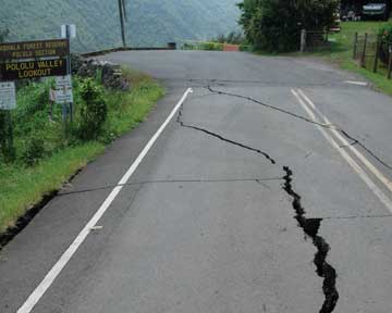 |
| The earthquakes and subsequent rockfalls damaged a road leading to the Pololu Valley overlook in Kohala. Photograph is by M. P. Poland, USGS Photos. |
To compare the events, the researchers first determined the orientations of the fault lines and the directions in which the earth slipped along those faults. The scientists noticed that the deeper earthquake resulted from forces stretching the ground apart, while the shallower earthquake was the result of forces squeezing the ground together. Furthermore, although at different vertical depths, in both cases the highest-stress regions were not centered directly under the heavy volcanic island, but occurred around the rim of the bowl-shaped dip in the lithosphere, where the thick layer bows the most sharply.
Those data were consistent with the idea that the two earthquakes were releasing two kinds of stress from the flexing lithosphere, Kirby says. However, the data were still puzzling: While the first, deeper earthquake occurred at a depth corresponding to “where one would expect the high-stress layer to be, what struck me is that the second earthquake was deeper than I expected it,” Patrick McGovern, a geophysicist at the Lunar and Planetary Institute in Houston, Texas, reported at the AGU meeting.
Previous models of stress patterns in the lithosphere under an island suggested the earthquake should be shallower, McGovern says. However, those models assumed that the crust and mantle bent as one, rather than taking into account that the crust is stiffer than the mantle. Using a more realistic two-layer crust-and-mantle model to simulate the stresses in the lithosphere, McGovern found that the stresses concentrated at the top of the mantle can push the hypocenter of a potential earthquake deeper.
Such deep earthquakes due to flexing plates could occur elsewhere in the world, including along passive margins such as in the Atlantic coastal region, Kirby says. That region, which used to be hotter than it is now, has been contracting, which bends the plates and reactivates ancient fault lines produced when Europe and North America split apart — thereby creating “rare but sometimes very damaging earthquakes,” he says.
The scientists hope that by better understanding what causes these deeper, often high-magnitude earthquakes in Hawaii, they will be better able to prepare for future hazards, both on the islands and elsewhere.
Carolyn Gramling
Links:
"Strong earthquake shakes up Hawaii," Geotimes online, Web Extra, Oct. 16, 2006
