On Oct. 8, a magnitude-7.6 earthquake shook Kashmir, a region split by Pakistan
and India. Most of the damage took place in the Pakistan-governed portion of
the region, amplified by a multitude of landslides large and small that cascaded
down the steep mountainsides of the Himalaya.
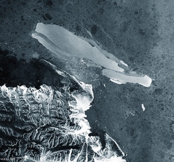
One such landslide, pictured in this issue (Print
Exclusive), brought down a hillside above the Neelum River,
north of the Pakistani region’s capital of Muzaffarabad. The dolomite and
limestone, sedimentary rocks from the Muzaffarabad Formation, were laid down
during the Precambrian (590 million years ago), according to Ahmad Hussain of
the Geological Survey of Pakistan. Lieutenant Colonel Wiley C. Thompson, a graduate
student in geosciences at Oregon State University who is currently serving in
Afghanistan, took this photo on Oct. 28, while participating in American relief
operations in Kashmir.
After the earthquake, relief to the region slowly trickled in, hampered by destroyed
roads, weather, and political disputes over where, how and when rescuers could
go — as well as by a small international response in comparison to the
philanthropic outpouring to the tsunami-devastated Indian Ocean countries, after
the December 2004 earthquake in Sumatra. At the end of November, the United
Nations estimated its relief efforts were short by about half of the funding
necessary to help more than 400,000 people who remained reliant on relief aid
as winter conditions closed in above elevations of 1,500 meters (about 5,000
feet).
In addition to landslides throughout the region, Muzaffarabad and the surrounding
towns and villages suffered devastating shaking that collapsed houses and apartment
buildings as if they were toy structures, causing them to pancake and crumble
(see Geotimes, December 2005). More
than 73,000 people died in the immediate aftermath.
For initial coverage of the Kashmir earthquake,
visit the Geotimes Web Extra archive.
 Icy
breakup
Icy
breakup |
Geotimes Home | AGI Home | Information Services | Geoscience Education | Public Policy | Programs | Publications | Careers |