
|
 Subscribe

Feature
Buried Beneath the Black Sea: Cities and Ships Submerged
Carolyn Gramling
Discovering volcanoes old and new
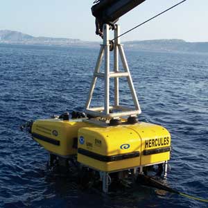 |
| Above: A team of archaeologists and geologists used Hercules — not the ancient strongman of Greek legend but a remotely operated vehicle that was specifically designed to survey and excavate ancient sunken ships — to explore the floor of the Black Sea. Photograph is by Todd Viola; Immersion Presents. Below: Jason brings King Pelias of Thessaly the Golden Fleece in this painting on a clay vessel, dating to between 340 and 330 B.C. Image is courtesy of Collection of Joseph-François Tochon d’Annecy. |
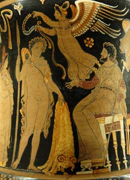 |
According to Greek mythology, on the eastern shores of the Black Sea, there was once a kingdom called Kolchis. Located in what is today the Republic of Georgia, this kingdom was said to be the home of the Golden Fleece, the legendary treasure that Jason and his Argonauts set out to find and bring back to Greece.
The Argonauts’ quest across the previously unexplored Black Sea to bring back treasure is an allegory of the Greeks’ own exploration, and eventual colonization, of the region, says Robert Ballard, an archaeological oceanographer at the University of Rhode Island (URI). Searching not only for gold, but also for fish, the Greeks “went in both friendly and as a raiding party,” he says. “They made it into a wonderful journey.”
For more than two decades, Ballard has been on his own epic quest to merge oceanographic tools and techniques with archaeological methods, in an effort to uncover long-buried historical treasures — such as the R.M.S. Titanic, which Ballard discovered in 1985, hidden under 3,800 meters of water in the North Atlantic Ocean.
In the summer of 2006, Ballard continued this quest in the Black Sea, spearheading one leg of a series of expeditions in the region that aimed to uncover geological and oceanographic evidence of classical human history buried under the waters bordering Greece, Turkey and Ukraine.
Underwater museum
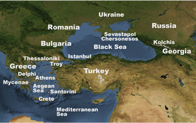
Long an important trading center and crossroads of human civilization, the Black Sea has seen the rise and fall of nations over thousands of years. Although its vast waters may have daunted ancient explorers, the Black Sea is, in fact, only barely a sea. Bordered by modern-day Bulgaria and Romania to the west, Turkey to the south and Ukraine to the north, it is nearly landlocked, connected to the Mediterranean Sea only through the narrow, dangerous Bosporus and Dardanelles straits.
Fed by several major European rivers, the surface waters of the Black Sea are also only half as salty as the ocean. To a depth of about 50 meters, these waters support abundant marine life, from zooplankton and mollusks to fish and dolphins. Below that surface layer, however, lies denser, saltier water. From about 200 meters all the way down to the sea’s bottom — about 2,000 meters at its deepest point — the water is almost completely oxygen-free, or anoxic. This layer gives the Black Sea the distinction of being the largest anoxic body of water in the world: Because the density difference between the two layers is so large, they rarely mix, and the colder, denser waters of the bottom rarely receive any influx of oxygen from above.
These conditions make the Black Sea a unique laboratory for scientists to study its physical, chemical and biological properties. But the low-oxygen conditions also offer something to archaeologists and historians: Many organisms that consume and break down organic materials cannot survive in that environment. Therefore, Ballard and other scientists suggest, ships’ hulls and other often-fragile clues to ancient civilizations are likely still well-preserved and intact under the sea’s dark waters. “It’s a veritable museum there,” Ballard says.
The labors of Hercules
In May, the team set out for the northern Black Sea on board URI’s R/V Endeavor, preparing to do some of the first deep-water archaeology around the Crimean peninsula. To help them on this expedition, Ballard, also the founder and head of the Institute for Exploration (IFE) at Mystic Aquarium in Connecticut, and his team brought along Hercules — not the ancient strongman of Greek legend, who accompanied Jason on his quest for the fleece, but a remotely operated vehicle (ROV) that was specifically designed by archaeologists, geologists and engineers to survey and excavate sunken ships of antiquity.
The team used Hercules and IFE’s “towfish” Echo, which carried sidescan sonar and sub-bottom profiling instruments to map the seafloor, to scan more than 650 square kilometers of underwater terrain in the hunt for archaeological treasures from ancient shipping routes to paleoshorelines. Hercules is part of a coupled robotic surveying and sampling system. The ROV is connected by a 30-meter-long tether to Argus, a “towsled” that is connected to the ship by a cable and is equipped with multiple lights, high-definition cameras and temperature, salinity and pressure sensors. Hercules also has its own high-definition cameras and sensors, as well as a pair of manipulator arms to collect samples.
 |
| Image is courtesy of NASA’s Earth Observatory and AGI. |
The 2006 expedition, which was conducted in collaboration between URI and the Department of Underwater Heritage of Ukraine, was looking for evidence of ancient deep-water trade routes from the Bronze Age, at about 1500 B.C., to the Byzantine period, about A.D. 1000, Ballard says.
One principal question that historians ponder is how well the ancient mariners were able to navigate far from land. Some argue that rather than cutting directly across the Black Sea along the shortest route, captains in antiquity would have preferred to stay close to the shoreline to avoid navigating through the tricky currents and winds out in the middle of the sea. Others, however, suggest that ancient mariners had no difficulty venturing far from shore. Given the Black Sea’s unique preservation ability, Ballard thought that if the team searched along the suspected trade routes, it might be possible to find evidence of Bronze Age ships lying intact on the seafloor — supporting the idea that some ancient captains did take the shortest route, and were willing to rely on their navigation skills.
To test this, the team focused on trade routes that may have led directly from the ancient Greek colony of Chersonesos — established about 2,500 years ago in the southwestern part of Crimea, near modern-day Sevastopol — to the Bosporus Strait. At a key location on the peninsula and possessing deep-water harbors, Chersonesos was a primary transit point for maritime trade from the Bronze Age through the Byzantine era.
To study the site, the team used “traditional archaeological survey techniques” that Ballard modified for deep-sea work, says Katy Croff, a URI graduate student in archaeological oceanography. Previous underwater archaeology studies, limited by technology and time, have focused on studying a specific wreck. The 2006 expedition, however, aimed to do a large-scale archaeological survey of the area to figure out which sites might be of most interest, she says. “We wanted to find as much as we could first, rather than camping out at one place and then finding out that 100 feet away there is something more interesting.”
When surveying a site on land, archaeologists generally create a grid, demarcated by lines of string, to keep track of the distribution of artifacts within the site. Underwater, the task requires a bit more hardware, but the principle is the same, Croff says. Instead of lines, “we used side-scan [sonar] to find targets to go back to,” she says. “This is one of the first large-scale underwater surveys of its kind.”
The team crisscrossed the northern Black Sea with the sidescan sonar, which mapped strip after strip of seafloor. To “see” what the seafloor looks like, the sonar sends out acoustic pulses to the seafloor that bounce off irregularities on the bottom, such as rocks and ripples. It then records the reflected energy. The pulses reflecting off sand ripples — or half-buried shipwrecks — will create a very different sonar picture from that of a smooth, muddy bottom.
With the sonar, the researchers discovered several sunken ships from the region’s thousands of years of history, including a World War II-era Russian ship sunk by a German torpedo, says Dwight Coleman, a marine geologist also at URI, who was a co-chief investigator on the expedition.
The team also discovered a late-Byzantine-era vessel from the 10th century, loaded with ancient one-handled clay jars called amphorae, Coleman says. “It lies right along a suspected trade route between Chersonesos and Istanbul,” he says. The ship was found about 24 kilometers offshore — still within sight of land, but not hugging the coast. That suggests that Byzantine-era captains did indeed know how to navigate across the open waters and were familiar with the wind and current patterns, he says. Although the ship does fall along the suspected trade route, however, “it’s hard to scientifically say ‘it’s on this route’ until we collect more data,” he adds.
Although armed with Hercules, which can collect not only images but also artifacts, the team has not yet begun to excavate their find. “Everything we did was non-intrusive — we just took pictures,” Croff says. Although the team is curious about what the amphoras might hold, which could include “wine, olive oil or fish guts,” she says, “collecting artifacts requires conservation,” which the recent expedition wasn’t set up to do. “This material has been down there for thousands of years and it’s still well-preserved. If we know where it is and how to get back to it, the best place for it is really on the seafloor,” Croff says. Conservation of the clay artifacts, once removed from their underwater environment, requires first and foremost that they must be kept damp, and then only very slowly dried, to avoid cracking.
The team plans to return to the site in August to begin its excavation in earnest. “This is really just the beginning,” Ballard says. “We’re happy to really move forward next year — once you start excavating, that’s when the discoveries really come.” And upon the team’s return, Hercules will also take more than just pictures, he says.
After the flood
Although shipping routes were a primary target, the Black Sea expedition also had another goal, Coleman says: to continue a long-standing quest for ancient shorelines, drowned river valleys and human-built structures that all suggest a once-shallower Black Sea. At one time, the Black Sea was a freshwater lake, and the water level was much lower during the last glaciation — but when, and especially how rapidly, it became a sea is still hotly debated.
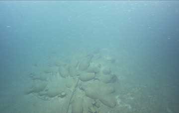 |
Ceramic jars dating to the 9th to 11th centuries A.D. were found on the floor of the Black Sea along a possible trade route between Istanbul and Chersonesos on the Crimean Peninsula.Image is courtesy of IFE, URI GSO, and the URI Institute for Archaeological Oceanography. |
In 1997, Walter Pitman and Bill Ryan of Columbia University proposed a controversial hypothesis: that the sea level abruptly rose about 7,200 years ago, due to salty Mediterranean water breaking through a natural dam across the Bosporus Strait and flooding the freshwater Black Sea — timing that they note coincides roughly with the biblical story of Noah’s Flood (see Geotimes, February 2004). The hypothesis is still disputed, and archaeologists, historians and oceanographers continue to search for evidence of Neolithic sites that might have been inundated by the rising sea.
“Most of looking for these archaeological sites is an exercise in geology — looking for evidence of ancient shorelines,” Coleman says. Additionally, he says, geological training is necessary to sort out those ancient shorelines from modern sedimentary environments on the shelf, which are likely due to the density gradient in the Black Sea.
That strong density difference, which keeps the sea’s layers mostly stable and in place, can still produce some interesting effects, Coleman says. For example, sonar pulses sent from the upper layer can bounce off the higher-density layer. Additionally, internal “waves” that never see the surface can travel along the interface between the high- and low-density layers of water, he says. Once those waves reach the shelf, they break. “At 150 meters deep, we see evidence of sedimentary bedforms that look like sand waves,” he says. Those bedforms can easily be confused for buried shorelines.
Correctly interpreting evidence of ancient shorelines, therefore, requires understanding “landscape archaeology, or environmental archaeology” as well, Coleman says. “We’ve mostly identified places where paleoriver channels have flowed across the shelf, evidence of terrestrial flora such as grass growing, and peat deposits and deposits within cores that are evidence of an arid and subarid landscape,” he says. The researchers also identified sites with shoreline features such as smooth, well-rounded beach stones and intact bleached mollusk shells — a freshwater species dating to more than 7,000 years ago, he says. Such mollusks could only have lived in nearshore environments that became inundated and were preserved by rising sea levels.
The team has also mapped the layers of sediment that lie underneath parts of the Black Sea floor, using a “sub-bottom profiler,” also mounted on the towfish Echo. The sub-bottom profiler sends sound pulses toward the seafloor. As in seismic reflection surveys, some of the sound reflects off the seafloor and some of it may penetrate it, providing information about the thickness, composition and slope of the seafloor’s layers. These data, collected about 15 to 30 kilometers off the coasts of northern Turkey and southern Ukraine and up to 50 kilometers off the coast of Bulgaria, could potentially be interpreted as representative of coastal and nearshore structures and paleo-shoreline deposits, Coleman says.
The data also reveal that the sea hides other features fascinating to geologists and oceanographers, Coleman says. “We have compiled some geologic cross sections that show active slumping going on off the slope, and other geologic processes,” such as underwater landslides likely triggered by earthquake activity and turbidity currents, he says.
Opening up the sea
“The Black Sea is absolutely fascinating, and largely unexplored,” in part because the region only opened up to Western scientists at the end of the Cold War in the late 1980s, Coleman says. Since Ryan and Pitman published their high-profile work in the 1990s, the Black Sea has attracted more attention, he says, but the region still retains much of its mystery. And although the Golden Fleece is long gone, the sea still holds plenty of treasure for intrepid explorers to find.
“There are so many places still to be explored,” Croff says. “Especially underwater.”
|
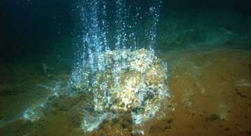
Discovering volcanoes old and new There occurred violent earthquakes and floods, and in a single day and night of misfortune. . . the island of Atlantis . . .disappeared in the depths of the sea. — Plato, Timaeus In the late Bronze Age, at about 1630 B.C., an explosive volcanic eruption buried part of the Greek island of Thera under tens of meters of ash and rock. In the explosion, the caldera that once formed the center of the island, now called Santorini, collapsed and fell into the sea. The eruption triggered earthquakes and tsunamis that swept over the surrounding islands, and its pyroclastic flows of ash and pumice quickly poured out across the Mediterranean Sea, extending as far as Crete.
The disaster, a catastrophic event that some investigators suggest may also be the subject of Plato’s dialogue Timaeus, in which he tells of the destruction of Atlantis, has long been considered by geologists to be one of the largest eruptions in recorded human history, says Haraldur Sigurdsson, a volcanologist at the University of Rhode Island (URI). Sigurdsson and a team of scientists from both URI and Greece’s Hellenic Center for Marine Research traveled to Santorini in the summer of 2006 to examine the geologic evidence still lingering on the seafloor from the Minoan eruption — so called because the Minoan civilization dominated the eastern Mediterranean at the time. “When you’re dealing with a big volcanic eruption, the first thing you want to know is how big is it,” Sigurdsson says. Because the eruption occurred far from land, “over 90 percent of [the deposits are] on the seafloor,” but no one had yet studied the seafloor in detail to piece together the past, he says. Sigurdsson’s expedition was one leg of a series of expeditions to the Mediterranean and the Black seas from May to June 2006, each with the common goal of using oceanographic methods to search for clues to ancient human history (see main story). The Santorini expedition actually comprised two smaller expeditions, Sigurdsson says: one, conducted on board the Greek vessel R/V Aegaeo, studied the stratigraphy and layering of the volcanic deposits on the seafloor around Santorini to better assess the Minoan eruption’s overall size and impact. The second, on URI’s vessel R/V Endeavor, deployed the remotely operated vehicle (ROV) Hercules to take a closer look at some promising targets on the seafloor, and also investigated the nearby younger Kolumbo volcano. Previous estimates of the total volume erupted during the Minoan catastrophe, made in 1975 from cores and land-based evidence, had been about 39 cubic kilometers — “a pretty respectable size,” Sigurdsson says. For comparison, he says, Washington’s Mount St. Helens erupted about half a cubic kilometer of material in 1980, and the 1883 eruption of Indonesia’s Krakatoa — one of the largest in recent history, which was said to have altered global weather patterns for many months — ejected about 10 cubic kilometers of rock, ash and pumice into the sky. While measuring the thickness and volume of the deposits around the island, however, the team discovered that the Minoan eruption was nearly twice as large as the previous estimates, at 60 cubic kilometers of rock and ash. The researchers found volcanic deposits up to 80 meters thick as far as 20 to 30 kilometers from the volcano, Sigurdsson says. Ash fallout from the volcano, transported in the upper troposphere, has also been found far to the east, in Turkey, the Black Sea and the Nile Delta, and possibly even in Asia. Earlier evidence from tree rings had pointed to a global cooling around this time, but it was hard to pinpoint the precise cause, as both Mount St. Helens and Vesuvius had also erupted within 50 years of the Thera eruption, Sigurdsson says. “But now it’s clear that this was the biggest event.” As devastating as the ancient Minoan eruption must have been, however, scientists and local citizens are keeping a more watchful eye on its nearby younger cousin, Kolumbo. The volcano is one of a chain of about 20 underwater volcanoes that follow along a rift northeast of Santorini. Kolumbo erupted as recently as 1950, but its last major eruption was in 1650, when it briefly formed an island that soon disappeared — and also generated a pyroclastic surge of searing hot ash and rock that killed 70 people on Santorini. Today, Kolumbo’s summit is 500 meters below the sea surface, and its caldera extends down to a depth of 1,500 meters. One of the big surprises of the cruise, Sigurdsson says, is that the caldera includes a large hydrothermal vent field. “It’s very active, with vents rising several meters above the seafloor, spewing out a lot of gas,” he says. The vents are also actively forming “Kuroko”-type mineral deposits that contain large quantities of lead, zinc, copper, silver, antimony and gold, named for a type of deep-sea rare-metal deposit found near Japan, he says. The find is particularly exciting because it is renewable, and has only formed since the 1650 eruption, he says. Even more important, perhaps, is the information that the hydrothermal vent field can give about where the next volcanic action is likely to be. “When you look at the seismic activity, the earthquake distributions in the area, almost all of the activity is in the Kolumbo field,” Sigurdsson says. “It is an active volcano that last erupted in 1950 — it’s clear that there should be more focus on the study of that area, from a hazards point of view.” And indeed, he says, “the average person in Santorini says they’re much more afraid of Kolumbo.”
CG |
Gramling is a staff writer for Geotimes.
Links:
"Black Sea Floods," Geotimes, February 2004
