
|
 Subscribe

NEWS NOTES
Desperately seeking salt dome
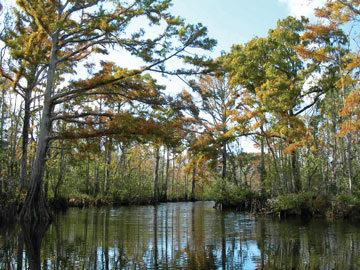 Courtesy of the Pascagoula River Audubon Center |
| Some Mississippians say diverting billions of gallons of water from the nearly pristine Pascagoula River to expand the Strategic Petroleum Reserve will cause irreparable harm to the river’s wildlife. |
On a mild evening in April, hundreds of Mississippians gathered at the civic center in Pascagoula, Miss., for a town hall meeting. They turned up en masse to oppose a $4 billion project that several people called a “boondoggle.” Although the moderators limited speaking time to three minutes per person, the meeting dragged on for more than three hours. At issue? Expansion of the Strategic Petroleum Reserve.
The Strategic Petroleum Reserve consists of four sites along the Gulf Coast where government-owned crude oil is stored belowground in enormous hollowed-out salt domes. Since 1975, the reserve has held hundreds of millions of barrels of oil for emergencies. In 2005, Congress voted to expand the Strategic Petroleum Reserve from 727 million barrels to an even 1 billion barrels. If all goes according to plan, much of that extra oil will be pumped into a salt dome beneath Richton, Miss., less than two hours north of Pascagoula.
The Department of Energy (DOE) says the project will bring jobs to the area. But some Mississippians argue that the economic boost won’t come close to offsetting the potential environmental damage wrought during the construction phase. “This is a half-baked plan,” said State Senator Deborah Dawkins at the meeting. “I intend to fight it every step.”
The problem is not where DOE plans to put the reserve; it’s how they plan to build it. The subterranean salt dome, which lies beneath approximately 28 square kilometers just west of Richton, is solid. To create space for the oil, DOE plans to pump in 50 million gallons of freshwater each day from the nearby Pascagoula River. Over four or five years, the water will dissolve enough salt to create 16 large caverns capable of holding 160 million barrels of oil. The waste — tens of billions of gallons of brine — will be released into the Gulf of Mexico.
The technique, called solution mining, is not new. In fact, the existing reserve sites in Texas and Louisiana were constructed in a similar manner. “What you have is a very cost-effective way to create large-volume storage,” says Steven Seni, a geologist formerly with the Railroad Commission of Texas who now works as a consultant.
But not everyone sees it that way. “In light of the drought that we’re experiencing, they’d have to be the craziest people in the world to take that much freshwater and destroy it,” says Eric Richards, a spokesperson for the Gulf Conservation Coalition, a group of concerned citizens who banded together in December to fight the project.
The Pascagoula is the last unimpeded river system that flows into the Gulf of Mexico. The river basin boasts wetlands designated as essential fish habitat by NOAA’s National Marine Fisheries Service, state-protected lands and several rare and endangered species.
Locals already draw some 55 million gallons of water from the Pascagoula each day for irrigation, livestock and industry. Richards says that taking an extra 50 million gallons will substantially reduce the flow, allowing saltwater from the Gulf to travel farther upstream and damage freshwater habitat.
Residents say alternatives exist. But proposals to get the water from elsewhere — either the Mississippi River or the Gulf — may not be viable options, Seni says. Using seawater to hollow out the caverns would require much greater volumes of water, as seawater can’t dissolve as much salt as freshwater can, and pumping in water from the Mississippi, which is farther away, would be more costly.
Residents and local scientists are also concerned about the potential impacts of dumping leftover brine into the Mississippi Sound. DOE plans to inject the brine via diffusers onto the seafloor about 30 kilometers off the coast. There, DOE says, the brine will mix with the less-salty seawater. The agency contends that brine has been similarly disposed of in Louisiana and Texas with no ill effects. But the hydrology that exists off the coast of Mississippi may be different from what exists off the coasts of other states, says Bill Walker, director of the Mississippi Department of Marine Resources in Biloxi. “I’m encouraging the DOE to help us fund a study in the discharge area to determine what the current patterns are.”
The Gulf Conservation Coalition says DOE should put the brine underground in deep injection wells. But DOE says that the process of carving out caverns in Richton will generate too much brine for injection or, another option, desalinization.
DOE has been trying to find a new site for petroleum storage since 2005. The agency considered several sites, but in February 2007, following environmental assessments, it finally selected Richton. Mounting public opposition late last year led DOE to start preparing a supplementary environmental impact statement. The agency held its first four public hearings in April. Although the public comment period ended on April 29, residents still have plenty of time to voice their support or opposition. A draft of the supplementary environmental impact statement should be ready for public review next spring.
Even if DOE does build a reserve in Richton, the caverns won’t be ready to receive any oil before 2018.
Links:
Petroleum reserve filling halted, Geotimes, July 2008
Oil: Is Now the Time to Fill the Strategic Petroleum Reserve?, Geotimes, March 2008

