
 Although there
was a time in the not too distant past when the only Americans to visit Nicaragua
were covert CIA operatives and intrepid journalists, the country has since broken
the cycle of violence and embraced democracy, ushering in a period of peace and
stability. Today, Nicaragua has a great up-and-coming energy to it, like when
a new hip bar comes to town.
Although there
was a time in the not too distant past when the only Americans to visit Nicaragua
were covert CIA operatives and intrepid journalists, the country has since broken
the cycle of violence and embraced democracy, ushering in a period of peace and
stability. Today, Nicaragua has a great up-and-coming energy to it, like when
a new hip bar comes to town.
Students and merchants fill its bustling cities, which contain a wide variety of locally owned restaurants and family-operated hotels. Still, even the most popular tourist destinations remain largely untouched by the globalization of giant hotel chains and fast food restaurants, and most small towns remain almost completely isolated. But day trips from the major cities make it possible to see Nicaragua's best geologic features — its volcanoes — which are evenly spaced across the countryside.
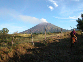
Steam and ash slowly rise from San Cristobal's 600 meter-wide crater. San Cristobal is not the tallest volcano in Nicaragua, but it is the most massive. It is locally known as El Viejo, which translates as "the old one." Photos by Jay Chapman.
Part of the so-called, "Ring of Fire," Nicaragua's volcanoes run parallel to the Pacific Coast, which stretches northwest toward El Salvador and southeast toward Costa Rica. The volcanic front is formed by the subduction of the Cocos Plate beneath the Caribbean Plate. A similar process occurs in the Pacific Northwest, where the Juan de Fuca Plate plunges beneath the North American Plate. None of the volcanoes in Nicaragua are currently erupting; however, geologists classify many of them as active, and the risks associated with volcanic hazards are high. Ash, steam and small rubble emanate daily from their craters.
 The mother of
all volcanoes in Nicaragua is San Cristobal, which looms over the university
town of Leon — the intellectual and artistic center of the country. San
Cristobal is a stratovolcano that rises more than 1,500 meters from the lowland
plains to a giant crater spewing steam and ash. It is possible to hike to the
rim, but an easier option is to rent a horse for the day. Either way, you will
need a guide to show you the way through the dense tropical dry forest and network
of trails.
The mother of
all volcanoes in Nicaragua is San Cristobal, which looms over the university
town of Leon — the intellectual and artistic center of the country. San
Cristobal is a stratovolcano that rises more than 1,500 meters from the lowland
plains to a giant crater spewing steam and ash. It is possible to hike to the
rim, but an easier option is to rent a horse for the day. Either way, you will
need a guide to show you the way through the dense tropical dry forest and network
of trails.
Right next to San Cristobal is the smaller and somewhat odd-shaped La Casita volcano. Here, in 1998, heavy rainfall related to Hurricane Mitch caused severe landslides and lahars that killed more than 1,000 people — mostly peasant farmers living in rudimentary housing at the base of the volcano. Throughout Central America, landslides are the deadliest geologic hazard. A seldom-traveled cobbled road, which crisscrosses the landslide area, leads to the summit.
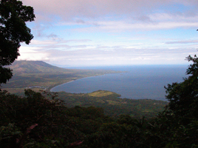
Orographic clouds — clouds formed by air forced over earth's topography — engulf Concepcion, the most symmetrical volcano in Central America and tallest in Nicaragua. Concepcion, together with Maderas volcano (where this picture was taken), form the dumbbell-shaped island of Ometepe in Lake Cocibolca.
One of the most overlooked but loveliest volcanoes in Nicaragua is Cosiguina. Tucked away in the northwest corner of the country, Cosiguina forms its own peninsula that juts out into the Gulf of Fonseca and Pacific Ocean. Its gentle slopes lend themselves to hiking, but you can also rent horses in Potosi, a nearby fishing village. The real gems of Cosiguina, apart from the stunning views from the summit, are the precipitous cliffs of its crater and the dazzling lake at the bottom. The eruption that created the 2-kilometer crater in 1835 is the largest in Nicaragua's history. Scientists now consider Cosiguina dormant.
 Far from dormant,
Nicaragua's youngest volcano is Cerro Negro, a 250-meter basaltic cinder cone.
In the mid-1800s, lava started spurting from a farmer's corn field, and it hasn't
let up since. Although the volcano rises from bleak, seemingly lifeless lava
fields, it attracts many colorful characters. Snowboarders and skiers routinely
ride down Cerro Negro's flanks on its loose volcanic scree. In 2002, a Frenchman
broke the world speed record for mountain biking at more than 100 miles per
hour on the volcano.
Far from dormant,
Nicaragua's youngest volcano is Cerro Negro, a 250-meter basaltic cinder cone.
In the mid-1800s, lava started spurting from a farmer's corn field, and it hasn't
let up since. Although the volcano rises from bleak, seemingly lifeless lava
fields, it attracts many colorful characters. Snowboarders and skiers routinely
ride down Cerro Negro's flanks on its loose volcanic scree. In 2002, a Frenchman
broke the world speed record for mountain biking at more than 100 miles per
hour on the volcano.
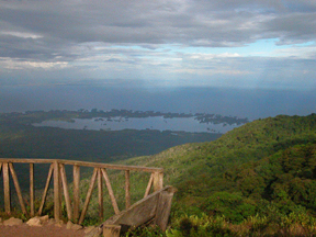
Looking out from the biological research
station atop Mombacho volcano, the Las Isletas island groups juts into Lake
Cocibolca. Geologists debate the origin of the islands, but the leading theory
is that a large debris avalanche created the islands.
Cerro Negro isn't the only volcano with adventure sports. Both Momotombo (outside
Managua, the nation's capital) and Mombacho (overlooking the colonial city of
Granada) have zip-line canopy tours. The zip-line tour originated in Costa Rica
in the early 1980s as a way to enhance ecotourism and has become a staple of
the tourism industry. On Mombacho, the tour zips between tall tropical hardwoods
that provide shade for a coffee plantation far below. Unlike other volcanoes
in Nicaragua, the upper reaches of Mombacho's slopes are protected from farming
and have become a haven for wildlife. There is a biological research station
at the summit that studies the diverse suite of insects, birds, amphibians and
mammals that make their home there.
On clear days, looking southeast from Mombacho, the almost perfectly symmetrical slopes of Concepcion volcano are visible in the distance. The beautiful Concepcion, together with the frumpy Madera volcano, forms the dumbbell-shaped island of Ometepe in the middle of Lake Cocibolca, Central America's largest lake. Rising sharply from the lake, Concepcion is the tallest volcano in Nicaragua, and its summit is often obscured by clouds, lending the island a mysterious and magical aura. Concepcion is one of the most active and dangerous volcanoes in Nicaragua. The inhabitants of Ometepe are clustered around the volcano's base — squeezed between the slopes and the sea. The only way on or off the island is by a stomach-churning ferry ride across the frequently turbulent lake.
Whether you visit all of Nicaragua's volcanoes or none at all, the once-troubled country is a wonderful travel destination. The tourism boom that hit Costa Rica in the last 20 years is just beginning to spread across the border. If you are looking for a less expensive, albeit more rustic, experience without sacrificing the natural wonders of a Central American country, Nicaragua is hard to beat. Daily expenses, including accommodations and meals, run $20 to $30. The aforementioned guides cost between $10 and $25 per group and horses rent for about $2 per person per day.
Jay Chapman
Geotimes contributing writer
Links:
Nicaragua
tourism Web site
USGS
Nicaragua volcanoes site
Real-time
Webcam of Nicaragua's volcanoes (in Spanish)
"In Harm's Way:
Population and Volcanic Risk," Geotimes, April 2004
 |
Geotimes Home | AGI Home | Information Services | Geoscience Education | Public Policy | Programs | Publications | Careers |