
 A magnitude-8.7
earthquake struck near the coastline of northern Sumatra at 11:09 p.m. local
time on Monday. Indonesia's National Coordinating Agency for Disaster Management
and Refugees has so far put the official death toll at 330, according to CNN,
with Nias Island and Simeulue Island hardest hit. Indonesia's vice president
has predicted that as many as 2,000 people may be dead (see Los
Angeles Times story). The epicenter of the earthquake was close to the
site of last December’s destructive earthquake, which set off a devastating
tsunami across the Indian Ocean that resulted in the deaths of nearly 300,000
people.
A magnitude-8.7
earthquake struck near the coastline of northern Sumatra at 11:09 p.m. local
time on Monday. Indonesia's National Coordinating Agency for Disaster Management
and Refugees has so far put the official death toll at 330, according to CNN,
with Nias Island and Simeulue Island hardest hit. Indonesia's vice president
has predicted that as many as 2,000 people may be dead (see Los
Angeles Times story). The epicenter of the earthquake was close to the
site of last December’s destructive earthquake, which set off a devastating
tsunami across the Indian Ocean that resulted in the deaths of nearly 300,000
people.
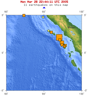
USGS published this preliminary map of
the location of Monday's earthquake in Sumatra, which was followed by smaller
earthquakes to the southeast. The magnitude-8.7 mainshock (the largest square)
occurred not far from last December's magnitude-9.3 event (see map below). Courtesy
of USGS.
No tsunami was triggered by the earthquake, but the possibility of a tsunami resulted in the evacuation of coastal areas for higher ground in Thailand and elsewhere. NOAA's Pacific Tsunami Warning system issued a bulletin warning that the earthquake "has the potential to generate a widely destructive tsunami" nearby and that "authorities in those regions should be aware of this possibility and take immediate action." The bulletin suggested evacuation of coastlines that are within 1,000 kilometers of the earthquake's epicenter, and suggests monitoring for sites farther away. The region currently has no tsunami monitoring system in place.
 David Applegate,
head of the USGS Earthquake and Geologic Hazards group, says that "the
rupture appears to have taken place on the Sunda trench," which is one
of the zones that researchers had determined had increased stress due to the
Dec. 26th event. Seismologists published earthquake risk estimates for the region
in the March 17 Nature, saying that a large earthquake was likely (see
"Sumatra seismic risk"). "I
should hasten to add, however, that the paper did not predict the earthquake
in the sense of specifying a time window," Applegate says. "Rather,
it suggested increased likelihood of an event."
David Applegate,
head of the USGS Earthquake and Geologic Hazards group, says that "the
rupture appears to have taken place on the Sunda trench," which is one
of the zones that researchers had determined had increased stress due to the
Dec. 26th event. Seismologists published earthquake risk estimates for the region
in the March 17 Nature, saying that a large earthquake was likely (see
"Sumatra seismic risk"). "I
should hasten to add, however, that the paper did not predict the earthquake
in the sense of specifying a time window," Applegate says. "Rather,
it suggested increased likelihood of an event."
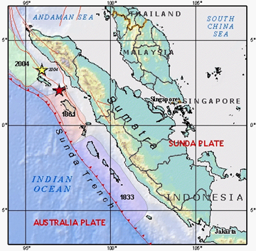
The Sunda fault is part of the subduction fault system that ruptured last year,
and today's earthquake had the same kind of fault movement as last year's event.
The epicenters are 179 kilometers apart, according to Paul Earle of USGS, with
today's earthquake occurring to the south (see map at left). He says that this
section of the fault zone last experienced a large earthquake in 1861, which
triggered a tsunami that hit Sumatra.
The December 26th earthquake is labeled
with a yellow star, and Monday's earthquake with a red one. The pastel-colored
zones show sections of the fault that ruptured in previous events. Courtesy
of USGS.
Yesterday's event is "not nearly the earthquake that the December one was," which has recently been estimated to magnitude-9.3, says John Vidale, a seismologist at the University of California at Los Angeles. The December event was at least three to four times larger, he says, so that even though the ground may have moved in the same way (along a thrust fault that could push ocean water), it didn't move as much, most likely. "As far as I know, we only know where this earthquake started," Vidale says. "It's hard to know the extent of the rupture," though it is probably big. And with regard to the recent work that calculated stress in the region, the fault the researchers said was the "most stressed is the one that broke," he said.
Magnitude-6.0 and magnitude-6.7 earthquakes also struck just southeast of the
8.7 event, within hours, according to USGS.
Naomi Lubick
Links:
CNN
story
Story at Los
Angeles Times
USGS
preliminary report on the magnitude-8.2 Sumatra earthquake
MSNBC
story
"Warning:
Tsunami," Geotimes, March 2005
 Order your free
trial copy of Geotimes!
Take advantage of your
special promo code.
Order your free
trial copy of Geotimes!
Take advantage of your
special promo code.
 |
Geotimes Home | AGI Home | Information Services | Geoscience Education | Public Policy | Programs | Publications | Careers |