
Check out this month's On the Web links, your connection to earth science friendly Web sites. The popular Geomedia feature is now available by topic.
Q&A: Author Frank Parchman
talks about his recent book Echoes of Fury. Print
Exclusive
Books: Riding
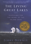
the Great Lakes: A review of The Living Great Lakes
DVDs: Libby,
Montana in review
Maps: Showcasing Gunnison Gorge
 The
Living Great Lakes The
Living Great Lakes
by Jerry Dennis. |
At the height of the industrial expansion of North America, the pollution of
the Great Lakes was widely accepted as unavoidable. The polluting industries
— steel, chemicals, aluminum, soda ash and heavy manufacturing — were
located on their shores to take advantage of the abundant water supply, access
to ports and inexpensive power. With the rare exception of Chicago, the cities
turned their backs to the lakes and largely put them out of mind.
Over the past few decades, the lakes have been rediscovered. Everywhere, cities
are building new waterfront facilities, resorts have been revitalized, the voices
of Native nations have been raised, and ancient traditions revived.
The commitment to revive the lakes was renewed at the first meeting of the Great
Lakes Collaborative, borne of a presidential directive for all federal agencies
with Great Lakes responsibilities to coordinate their activities. At this meeting
in Chicago in late 2004, governors, mayors, commissioners and American Indian
chiefs marched behind flags and bagpipes into a grand ballroom filled with environmental
advocates, scientists, reporters and bureaucrats.
The well-orchestrated ritual centered on a hope and a promise. The hope was
that the time had arrived when North America’s immense system of freshwater
seas would finally receive their due recognition as one of the world’s
greatest environmental treasures and that their care might become the aim of
an international environmental restoration effort on a scale worthy of their
grandeur and plight. The promise was that this group would lay out a common
strategy with a set of priorities for action that would make such restoration
efforts feasible. After signing a document pledging to work together toward
these goals, each dignitary made a brief speech, and most contained some variant
of the sentiment, “at last.”
Coincident with this meeting, I was reading The Living Great Lakes, by
Jerry Dennis. While reading it, I also thought, “at last.” Finally,
here is a book on the Great Lakes that is alive with a tone of awe and respect,
one that presents the fascinating details of bathymetry and limnology, chemistry
and biology, and meteorology and geography in the context of a great sailor’s
story rather than in the dry tones of an atlas. Not since the old children’s
book Paddle to the Sea, where a doll rode a toy canoe down perilous rapids and
a lonely expanse of lake to the sea, have the Great Lakes been presented as
the grand adventure they are.
This adventure takes place aboard the Malabar, a replica of the workhorse schooners
that, at the beginning of the 20th century, carried vacationers and tourists
from Great Lakes cities to the popular playgrounds of the Thousand Islands and
Mackinac Island. In the late 1980s, investors thought that the lakes might once
again attract people for pleasure cruises. But by the first years of the 21st
century, that dream was abandoned.
And so the Malabar, its cement hull patched together by the colorful captain
and his makeshift crew, makes one final sail from Michigan to the profitable
tourist market along the coast of Maine. Ironically, the journey on which the
author takes us is a farewell voyage. It’s just the right metaphor for
the book’s message: Take a close look at our lakes before they’re
gone.
There’s nothing like a seagoing adventure to remind us of the capricious
and unexpected mood-shifts of nature. Even more than most waters, the Great
Lakes have a way of surprising us with sudden winds and fickle currents. Great
Lakes mariners worked hard to know the lakes intimately, as their lives and
the lives of their passengers depended on it.
And even as Dennis writes eloquently about the power and beauty of the lakes,
he chronicles the many dangers that threaten their future: the steady influx
of invasive plants and animals that hitch rides in the ballast of cargo ships,
the rising pressure to remove water from the lakes to feed the thirst of expanding
suburbs and perhaps someday drought-ravaged prairies, and the continuing flushing
of industrial, agricultural and urban wastes from some of the largest U.S. and
Canadian cities.
This book, while lighthearted and adventurous throughout, reminds us without
preaching that our lives, too, depend on the lakes in more ways than we usually
notice and it’s high time we got to know these waters with something like
the respect and long-term commitment of seasoned sailors. I recommend that you
go along for the ride and reintroduce yourself to the living and very much alive
Great Lakes.
 For
decades, residents of Libby, Mont., worked, lived and played in the vicinity of
the Zonolite vermiculite mine, run by W.R. Grace since 1963. In the 1970s and
1980s, workers from the mine started to experience lung problems, and eventually,
many were diagnosed with diseases brought on by exposure to asbestos. On Feb.
7, a grand jury handed down an indictment of W.R. Grace, after a five-year asbestos-contamination
inquiry by the Environmental Protection Agency (EPA), stating that the company
engaged in fraud, obstruction of justice and conspiracy, in addition to Clean
Air Act violations, related to exposing the town of Libby to asbestos.
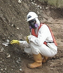
For
decades, residents of Libby, Mont., worked, lived and played in the vicinity of
the Zonolite vermiculite mine, run by W.R. Grace since 1963. In the 1970s and
1980s, workers from the mine started to experience lung problems, and eventually,
many were diagnosed with diseases brought on by exposure to asbestos. On Feb.
7, a grand jury handed down an indictment of W.R. Grace, after a five-year asbestos-contamination
inquiry by the Environmental Protection Agency (EPA), stating that the company
engaged in fraud, obstruction of justice and conspiracy, in addition to Clean
Air Act violations, related to exposing the town of Libby to asbestos.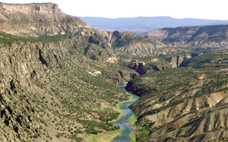 The 264-square-kilometer
Gunnison Gorge National Conservation Area (NCA) in western Colorado is one of
a number of protected regions recently created by Congress to preserve unique
and beautiful areas for future generations. The outstanding scenery, magnificently
exposed geologic formations and recreational opportunities within the Gunnison
Gorge NCA, such as kayaking, rafting, fishing, hunting, hiking and camping,
attract more than 10,000 visitors a year.
The 264-square-kilometer
Gunnison Gorge National Conservation Area (NCA) in western Colorado is one of
a number of protected regions recently created by Congress to preserve unique
and beautiful areas for future generations. The outstanding scenery, magnificently
exposed geologic formations and recreational opportunities within the Gunnison
Gorge NCA, such as kayaking, rafting, fishing, hunting, hiking and camping,
attract more than 10,000 visitors a year.
The Gunnison River canyon is in the heart
of the Gunnison Gorge National Conservation Area in western Colorado. A new
poster (shown below), book and map highlight the geology, ecology and human
history of the protected lands.
To showcase the geology of the scenic Gunnison Gorge NCA, the U.S. Geological
Survey (USGS) and the U.S. Bureau of Land Management recently published a 1:45,000-scale
map and companion book. Written and designed for members of the public, these
colorful and richly illustrated publications still retain the scientific content
to serve the needs of scientists and land managers.
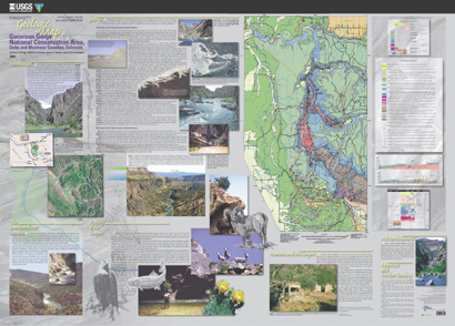 The
geologic map forms the centerpiece of an attractive poster that describes the
geology, ecology and human history of the NCA. Information for the map mostly
came from detailed geologic mapping by retired USGS geologist Wallace R. Hansen.
The companion book, The Geologic Story of Gunnison Gorge National Conservation
Area, Colorado, includes color photographs and figures that highlight and
explain many of the geologic features.
The
geologic map forms the centerpiece of an attractive poster that describes the
geology, ecology and human history of the NCA. Information for the map mostly
came from detailed geologic mapping by retired USGS geologist Wallace R. Hansen.
The companion book, The Geologic Story of Gunnison Gorge National Conservation
Area, Colorado, includes color photographs and figures that highlight and
explain many of the geologic features.
One intent of the map and book is to portray the NCA as a geology classroom
in which nonscientists can learn basic geologic principles. As an aid to nonscientists,
all technical terms used in the book are defined in a glossary. With the geologic
map and book in hand, the reader can explore and learn about the igneous and
metamorphic basement rocks that form the steep inner canyon and the colorful
sedimentary rocks that unconformably overlie the basement rocks. Readers can
also learn why all sedimentary rocks older than about 170 million years (Middle
Jurassic) are missing in the NCA, as compared to other areas in Colorado; why
the Gunnison River flows through the Gunnison uplift and not around it; the
origin of the spectacular Ute Indian fault, which cuts through the center of
the gorge; and the fascinating history of canyon cutting that has occurred during
the past 2 million years.
 |
Geotimes Home | AGI Home | Information Services | Geoscience Education | Public Policy | Programs | Publications | Careers |