
|
 Subscribe

Feature
Prevention Is the Best Medicine: Doing Site Evaluations to Prevent Geological Hazard Catastrophes
Scott Burns
Hazard potential online Print Exclusive
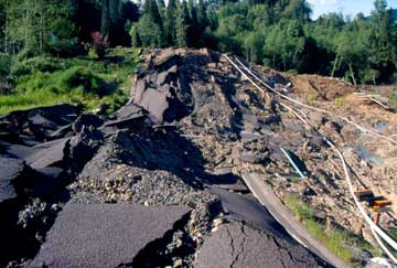 |
| In 1998, much of the Aldercrest-Banyon neighborhood of Kelso, Wash., was destroyed when a slow-moving landslide began beneath the houses and roads that were built atop an ancient landslide. Photograph is by Scott Burns. |
Following several years of above-average rainfall, in February 1998, land began to move in a residential neighborhood in Kelso, Wash. Over the next couple of months, some of the houses in this community 77 kilometers north of Portland, Ore., began to show signs of distress. Eventually, one house cracked, and several other homes had to be evacuated. Although the city tried to fix the damage by patching cracks in the streets, the rains had set in motion a catastrophe that could not be stopped — a slow-moving landslide.
In the end, the landslide had its way with the town, destroying 60 homes. The problem was that the site had been erroneously mapped as stable ground, when in fact, the homes had been erected on an ancient landslide that just needed a little extra rain to reactivate. This disaster could have been prevented, had engineering geologists gotten involved before the neighborhood was built.
The 5th edition of the Glossary of Geology describes engineering geology as a specialty of geology relevant to the planning, design, operation and maintenance of civil engineering works; the development, protection and remediation of ground- and surface-water resources; and other human activities where geologic factors and conditions impact the public welfare and the safeguarding of life, health, property and the environment. And that’s just about right. We investigate sites prior to development and provide recommendations, taking into account geologic hazards, landslide and slope stability, erosion, flooding, bedrock and soil types and, of course, the seismic risks.
Site evaluations are at the heart of what engineering geologists and geological engineers do. Since they emerged in the 1920s, these professionals have become the major investigators of the development potential of locations. Before constructing a street, railroad, airport, canal or building, the developer must know the geological limitations of each site. Engineering geologists and geological engineers work closely with the designers (geotechnical engineers and architects) to make sure that they understand the geological limitations of a site before building structures atop it.
The economic toll from geologic hazards in the United States reaches $52 billion per year, according to the U.S. Geological Survey. On average, earthquakes account for $4.4 billion of that annual damage, while floods account for $5.2 billion and landslides account for $3.9 billion of annual damage. Yet some, or even much of this is preventable.
No one wants a structure to fail. No one wants to have a loss of life, property or function. Preventing such losses from the failure of structures and resisting the impact of geological processes is of paramount importance to public safety. Engineering geology is about people — maintaining their safety while enabling them to benefit from development.
Conducting a site evaluation
Safety begins with a rigorous site evaluation, which is usually composed of analyzing countless datasets. First, we explore the geological materials of the site. We need to know the strengths and weathering characteristics of the bedrock and soil, and whether they can support the foundation. For instance, we need to know the structure of the bedrock and if joints, folds or faults are present. Likewise, we need to know if there are expansive clays in the soil or geologically weak bedrock, such as shale. Other important pieces of information include mapping the surficial deposits and landforms of the site, as well as the drainage system, because groundwater, springs and surface water can all affect a structure being built.
Second, we explore the geological processes, especially the natural hazards found at the site, to determine the possibility or probability of landslides, floods, earthquakes, coastal erosion, tsunamis or volcanoes striking the site.
Third, we determine if there are any geological constraints, including conditions from previous human activity on the site that have weakened or aggravated the stability of the earth materials. Previous mining operations leave sinking (or subsiding) ground, tunnels that might collapse when the timbers rot, abandoned open pits, or improperly graded mine spoils. A previous industrial plant may have contaminated the soil and groundwater of the site. Old coke plants, gas stations or dry cleaners, for example, may have left chemicals in the ground.
We perform site evaluations in two steps, beginning with consulting the literature for past geological reports, soil surveys, and geologic, topographic and hazard maps. If air photos are available, they should be consulted to understand the landforms. The Internet can also provide background information of hazard potential for sites (see sidebar). Maps and sketches summarize details of the site. Yet nothing substitutes for a site visit to directly observe the bedrock, fractures and faults, soils, landforms, human development, drainage and water. Indirect approaches using seismic techniques help also to gain subsurface information.
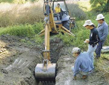 |
| U.S. Geological Survey researchers dig a trench in a fault near San Francisco to learn more about the fault’s characteristics. Photograph is courtesy of the U.S. Geological Survey. |
The impact of a site evaluation is felt in many ways. It might result in a change of the design of a structure because of a poor soil — for example, putting down stabilizing soil atop poor soils (such as expansive clays) before constructing a house — or a geological hazard, such as building a house off of the ground in a tsunami zone. Site evaluations might also lead to setting the structure back from a hazard zone, such as an active fault or at the top of a landslide. Or we could recommend somewhat simpler solutions such as grading soils of a steep site where slope stability is a problem, or building drains where groundwater flow is substantial on a slope. Or, of course, site evaluations could end up in complete rejection of the site because of weak soils or bedrock, or other problems with a hazard that would threaten the safety of humans and property.
While the hazards are varied and numerous, two geological hazards — earthquakes and landslides — are important to focus on because the background information is often incomplete, and geologic experience is central to success. Earthquakes can cause damage on a massive scale and come unannounced. In general, we know where they will occur, but the “when” part of the equation has been elusive. Significant earthquake hazard maps exist for California and Utah, but many other states have less than adequate coverage. Complicated by the public’s often short memories, the development of land at significant risk of earthquake damage remains a constant challenge for engineering geologists.
Landslides are equally important, as they can also significantly affect property owners, largely because there is essentially no insurance to cover damage from this hazard. We can predict where landslides might occur, and we know they have the greatest chance of occurring after periods of high rainfall. But, few landslide potential maps exist for use in land-use planning.
Both of these hazards need more focus to help reduce their impact on society and to help the investigators do better site evaluations.
Earthquake Evaluations
In earthquake-prone areas, site evaluators use four levels of building codes that equate to the level of earthquake potential, which is based on both potential earthquake magnitudes and the values of acceleration of the seismic waves. A site evaluator first needs to assess the earthquake potential for each site, determining whether or not there are local faults that could generate an earthquake or distant faults that could produce large earthquakes that could have a local impact from hundreds of kilometers away — such as the subduction zone earthquakes generated along the coasts of Oregon, Washington and Alaska.
If earthquake potential is discovered at the site, then the response of the local soils will need to be considered. The SHAKE-91 computer program, developed at the University of California at Berkeley, predicts the amount of parent material shaking at the site from either source of seismic waves. Sites with sandy soils and a high groundwater table are prime candidates for earthquake liquefaction, along with areas of steep slopes with unstable soils and old slope failures — all recipes for structural failures in an earthquake.
If local faults are determined to be active — that is, have shown movement in the past 10,000 years — then the site evaluator needs to determine three things: the recurrence interval for fault movement; the timing of the last movement on the fault; and the maximum-size of an earthquake one could expect for that fault. California is the leading state for generation of these types of data, which were incorporated into the maps of the state’s active fault systems, as mandated by the Alquist-Priolo Earthquake Fault Zone Act of 1972. (The act mandates that all major fault zones be mapped and regulatory zones be established for land-use planning.) If a fault has no data available, then site evaluators must trench the fault to evaluate the soils and to determine the three factors.
Landslide Evaluations
Landslides may not grab the headlines like other geological hazards, but the sustained losses are on par. As our population expands, we are spreading into areas where homes did not previously exist. These new areas of development are often only available because of their more complex engineering challenges. Often, these areas have unstable slopes. The first thing a site evaluator needs to do when evaluating an area for landslides is to determine the availability of any landslide hazard maps. In most localities, unfortunately, none exist (see story, this issue). And where landslide hazard maps do exist, evaluations may be based on only one of the following: old slides, the local geology or slope angles without geology. Though each is important, knowing about all three is imperative.
Determining if there has been previous landslide activity is of paramount importance: If a slope has moved before, it has a higher chance of moving than a slope with similar characteristics that has never moved. Characteristics such as scarps, toes, hummocky topography and seeps are geomorphic hints of old landslide activity. Building on the toe of an ancient slide that reactivates can cause slumping to occur. Reactivation of past landslides can be devastating if buildings and roads are built upon them. Once moving, many old landslides are difficult to stop, and the homes and infrastructure can be destroyed. Movement can occur after many years of inactivity, so sites are never safe.
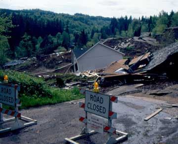 |
| Sixty houses were destroyed by a landslide in Kelso, Wash. The town of 14,000 people suffered more than $70 million of destruction from a landslide that could have been prevented if it had not been built atop an old slide. Photograph is by Scott Burns. |
Myriad examples of failed infrastructure from landslides exist around the country. In 2005, following heavy rain, the La Conchita landslide reactivated in Southern California, killing 10 people and destroying 36 homes (see Geotimes, November 2005). The same year, a slow-moving landslide in Laguna Beach, Calif., reactivated and destroyed 11 homes, and a number of multimillion-dollar homes were destroyed by similar landslides in Orange County, Calif. (see Geotimes, April 2005). In 1999, in Colorado Springs, Colo., 35 homes were destroyed when increased rainfall reactivated old landslides with houses on them, and caused $80 million of damage.
The Kelso, Wash., case is perhaps a perfect example of a disaster that could have been averted. The Aldercrest-Banyon neighborhood of Kelso was the first landslide disaster in the United States that the Federal Emergency Management Agency (FEMA) declared an official disaster area. This housing development, built in the early 1970s on an ancient, unmapped landslide, started moving in 1998. Once the large earthflow started creeping, water from broken storm drains fed abundant water into the system, further increasing movement rates. All told, 60 homes were destroyed, and homeowners in another 77 homes, located above the scarp, wondered if they were next.
The homes and infrastructure in this town of 14,000 people suffered more than $70 million of destruction. In the end, FEMA and the state of Washington offered a buyout of 127 homeowners at 30 cents on the dollar. Many homeowners suffered significant losses. This was the second largest landslide disaster in U.S. history involving homes on a landslide — the largest was in the Palos Verdes Hills of Southern California in 1956, when 130 of 160 homes on a 260-acre ancient landslide were destroyed when the landslide reactivated. The Kelso slide could have been prevented if the landslide had been mapped, and houses were not allowed to be built on it.
In the future, climatic change may also increase local landslide activity, if precipitation changes. Hurricanes, which some modelers have predicted to increase with global warming, dump copious rainfall in short periods of time in the Appalachian Mountains of the eastern United States, causing many small landslides and debris flows. If hurricanes increase in intensity or frequency, such landslides may likewise grow more frequent. Also, models suggest that some areas of the United States may see an increase in rainfall that could also lead to increased reactivation of ancient landslides, or could form more modern slides.
Of course, slopes without old failures must also be analyzed for landslide potential in a site evaluation. Bedrock geology is important — especially if it is shale or clay, as both are prone to landslides. Cincinnati, Ohio, for example, has had many landslides over the years because parts of the city are built on shale. Duty, La., is the site of a 130-square-kilometer landslide complex located on clay. Gas pipelines passing through this area have ruptured many times due to slope movement in the clay.
High slope angles can also increase the chances for landslides. Presence of “dip slopes,” where sedimentary rock layers are parallel to the slope surface, can also have high landslide potential if a clay layer is exposed in a roadcut from the slope. The clay layer can become an impermeable layer atop which water can flow, thus making it a potential slip surface for the landslide. In areas where debris flows and mudflows are common, valley bottoms and the fan surfaces below them are not good places to build structures because of the potential of destruction from the flows. Site evaluators today have many excellent slope stability programs to help determine potential stability of a site.
In the end, the geologic work necessary to evaluate a site for myriad geologic hazards prior to building isn’t too difficult, time-consuming or expensive, especially if you consider what’s at stake.
Burns is a professor of engineering geology at Portland State University whose research focuses on geological hazard mapping and landslides. He is past president of the Association of Environmental and Engineering Geologists. E-mail: burnss@pdx.edu.
Links:
"Hazard potential online," Geotimes, February 2007 Print
Exclusive
"Susan Cannon: Watching for flowing mud," Geotimes, February 2007
"Watching for Landslide Weather in California," Geotimes, November 2005
"Dream homes slip away," Geotimes, April 2005
