
Check out this month's On the Web links, your connection to earth science friendly Web sites. The popular Geomedia feature is now available by topic.
Maps: Mapping the seafloor for everyone
Books: Swooning over Scopes: A review of Monkey
Town: The Summer of the Scopes Trial
Books: In the Field with Darwin: A review of Charles
Darwin, Geologist
About a year and a half ago, a U.S. Navy submarine bumped into a mountain. The underwater seamount sits about 550 kilometers (350 miles) south of Guam, and despite being captured by satellite images, it remained uncharted.
 Indeed, the planet’s oceans
remain a blur, at a time when Google Earth and all sorts
of other digital mapping products boast the ability to map a surface with pinpoint
accuracy. Yet slow and steady political and scientific efforts to fill in underwater
mapping blanks may show some promise, scientists cautiously say, as federal
funding and interest seems to be trickling in.
Indeed, the planet’s oceans
remain a blur, at a time when Google Earth and all sorts
of other digital mapping products boast the ability to map a surface with pinpoint
accuracy. Yet slow and steady political and scientific efforts to fill in underwater
mapping blanks may show some promise, scientists cautiously say, as federal
funding and interest seems to be trickling in.
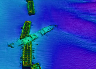
Multibeam sonar data captured this image of a shipwreck that came to rest atop the concrete chambers that American troops used to create Mulberry Harbor, in shallow water offshore France, during World War II. Image is courtesy of Larry Mayer.
In presenting the National Oceanic and Atmospheric Administration (NOAA) budget request last February, Vice Admiral Conrad Lautenbacher, the agency’s administrator, highlighted the Bush administration’s increase in funding to the Department of Commerce and Transportation to cover “critical mapping, charting and data improvements.” The requested allocation for fiscal year 2007 added $5.1 million, for a total of $41.8 million.
In particular, Lautenbacher said, the agency needs vertical set points that orient maps to the same elevation and spatial grid, which are lacking. Such “V datum” are “especially important” in the Gulf of Mexico, he noted, for both resources and ecosystems management, which are responsibilities carried out by different sections of NOAA, as well as other agencies.
That dispersal of responsibility has created problems historically, says Marcia McNutt, head of the Monterey Bay Aquarium Research Institute. The U.S. Geological Survey is responsible for mapping land but also has a marine geology division that in the past did some mapping, and NOAA’s Coast and Geodetic Survey maps land and nearshore environments for navigational charts. Past turf battles have broken out over differences in opinion about which agency should do what.
A National Academy of Sciences National Research Council (NRC) report published in 2004 attempted to settle some of these responsibility issues. The report laid out a course of action for the federal government to follow, to efficiently map its sovereign marine territory and fulfill its own responsibilities under the international U.N. Law of the Sea.
Larry Mayer, an ocean-mapping marine geologist and geophysicist at the University of New Hampshire in Durham, who chaired the NRC report, says that Japan has been sinking tens of millions of dollars annually into its marine mapping activities since the mid-1980s, to collect data in support of the Law of the Sea. Although the United States may be behind, Mayer says, “NOAA is making an effort” to work toward fulfilling recommendations made in the presidential Ocean Commission’s report (see Geotimes, July 2004) and the NRC report. The federal investment has occurred “slowly, and never to levels requested in the reports,” he says, but considering the current tightness of the federal budget, ocean mapping’s status “is not totally discouraging.”
One big leap forward will come with the conversion currently under way of the Okianas Explorer, a former naval ship, which will be committed to ocean exploration and seafloor mapping. But Mayer says that the biggest shifts have come with technology changes: Increased quality and accuracy now comes at more affordable costs, and evolving computer algorithms can now crunch data faster. These jumps have made the prospect of mapping the oceans seem more readily achievable, he says.
For example, one Canadian scallop fishing company has mapped large swaths of Canadian territory using a $1 million multibeam sonar system attached to its boat, Mayer notes. The gains for the company included quartering the time spent looking for likely habitat to harvest to fill their quota, thus reducing environmental impacts. Mayer says that U.S. fishermen have yet to adopt the same practice, perhaps because government-sponsored data they need are more easily available and free — thus reducing their desire for expanded, more expensive datasets.
Still, Mayer says that recently some U.S. fishermen walked into his office with portable hard drives to download the data collected by government-sponsored cruises. The digital format lets sea captains use the data in the same manner as GPS systems now available in cars.
In an endeavor that will cost millions of dollars a year, Lautenbacher said that NOAA wants to update and convert paper charts that cover the nation’s navigable waters to digital formats that can be used in the same fashion, by the end of 2010. With proposed funds for 2007, the agency would add some 3,000 square nautical miles of more accurate full-bottom coverage data, contained in 70 charts of all sizes, in addition to the 535 already completed (more than 400 are left to do by 2010).
Navigation, however, is not the only use of ocean maps. From resource extraction to ecosystems management to homeland security, different map users may collect different kinds of information at different resolutions for the same region. Scientists argue that uniform collection criteria would help to create a universal framework for all map users.
The Center for Coastal and Ocean Mapping at the University of New Hampshire hosted a NOAA-sponsored meeting last month, where different stakeholders began the process of hammering out such protocols. The eventual goal is a universal seafloor basemap for all users. A systemic, community-wide view will save time and money, says McNutt of the Monterey Bay Aquarium Research Institute, where researchers have pioneered underwater mapping techniques at high resolution, using autonomous robotic vehicles.
McNutt compares the current status of ocean maps to a grassy lawn into which many different people have mowed their initials: “You might as well go back and forth and mow the whole land,” in an orderly fashion using the same criteria, she says. Haphazard ocean mapping, like the crazed scrawls of a lawnmower run amuck, “isn’t going to save you one instant of time.”
Naomi Lubick
 Monkey
Town: The Summer of the Scopes Trial Monkey
Town: The Summer of the Scopes Trial by Ronald Kidd. Simon & Schuster Books for Young Readers, 2006. ISBN 1 4169 0572 3. Hardcover, $15.95. |
With a plethora of books about the Scopes trial already cluttering the shelves, including Edward J. Larson’s Pulitzer-Prize-winning Summer for the Gods, is there really a need for Ronald Kidd’s Monkey Town? Indeed, there is.
Today as in 1925, the controversy over evolution centers on the science curriculum of the public school system, and so teenagers are bound to be curious about its history. Yet treatments aimed at such readers tend to be sober factual accounts, short on narrative verve and dramatic flair. The exception, of course, is the play Inherit the Wind, which, though not aimed specifically at the young, nevertheless quickly became a staple of the high school classroom and the high school stage. For all its dramatic virtues, however, Inherit the Wind was not intended as a documentary: John Scopes himself quipped about the introduction of a fiancée for Bertram Cates, the character based on Scopes — “They had to invent romance for the balcony set.”
Kidd, too, invents romance for the purposes of his lively and appealing novel: His narrator Frances swoons over the handsome Scopes, fantasizing about the day that they will preside over Rhea County Central High School together. But despite this fictionalization, the setting, personalities and events of the Scopes trial are presented with scrupulous accuracy, and the few exceptions are certainly justifiable. For example, Frances is based on real-life Frances Robinson, who was eight years old at the time of the trial, but Kidd made narrator Frances older, 15 years old, presumably to connect to the intended teenage audience.
Monkey Town was inspired by a conversation Kidd enjoyed with Robinson in 1994, nearly 70 years after the trial. The plan to host the American Civil Liberties Union’s test case of the Butler Act — which forbade teachers in public schools “to teach any theory that denies the story of the Divine Creation of man as taught in the Bible, and to teach instead that man has descended from a lower order of animals” — in Dayton, Tenn., was hatched in the drugstore belonging to F. E. Robinson, Frances’s father. Thus Kidd has a pretext to arrange for Frances to witness or even affect the events surrounding the trial.
It is, however, a bit of a stretch for Kidd to have Frances help thwart a plot to run the Baltimore Sun’s caustic reporter H. L. Mencken out of town on a rail. (There in fact was such a plot, which Robinson’s grandfather helped to thwart.) A surprising, but delightful, touch in the book is that Frances eventually befriends Mencken, who is humanized by his love of music and his devotion to the women in his life.
Not all of the supporting characters receive such development, however. The only characters who are really fully portrayed are Mencken, Scopes and Frances herself. But the lack of character development is not a serious flaw in the book, as the young Frances would not have possessed a great deal of insight into the personalities of the glittering visitors to Dayton on the basis of a slight acquaintance, and the intended audience would not be tremendously interested in any case.
Despite a sometimes didactic tone, Kidd convincingly renders Frances’ struggle with reconciling her own conflicted feelings about science and religion, culminating in a theological position that may or may not be deliberately unresolved. During defense attorney Clarence Darrow’s famously withering examination of politician William Jennings Bryan, witness for the prosecution, Frances comes to the realization, “Evolution, like creation, could have taken place in seven days, if the days were long enough.” But then, when she broaches the subject with her father, he objects not to the interpretation of the days of Genesis but to the idea of common ancestry — “You think your Grandpa Haggard came swinging in on some tree?” — to which she lacks a ready answer.
With its lively dialogue, fast-paced plot and adroit use of historical detail, Monkey Town is a welcome contribution and important read — especially in a time where communities across the country still wrestle with the perceived religious consequences of evolution, and the quality of science education suffers as a result.
Branch is deputy director of
the National Center for Science Education in Oakland, Calif. E-mail: branch@ncseweb.org.
Back to top
 Charles
Darwin, Geologist Charles
Darwin, Geologist by Sandra Herbert. Cornell University Press, 2005. ISBN 0 8014 4348 2. Hardback, $39.95. |
The book title “Charles Darwin, Geologist” may seem to be an oxymoron, as the common perception is that Darwin was a biologist. Sandra Herbert’s well-produced book of that title, however, documents that Darwin was first a geologist. Through her many years of work on Darwin’s writings on geology, as well as a study of his extensive collection of specimens now held in Cambridge, Herbert does not narrowly focus on Darwin, but rather puts Darwin the geologist firmly into the context of the 19th century.
Despite all the ink spilled on Darwin, few realize that on the HMS Beagle, his primary passion was for geology, not biology. On the Galapagos, he wrote 10 times more notes on geology than biology, and he scarcely bothered about the finches!
Darwin’s active life as a geologist spanned the years from 1831 to 1842. In 1831, he spent two months studying the geology of Shropshire and North Wales, partly under the wing of the Reverend Adam Sedgwick (see Geotimes online, Travels in Geology, October 2005). During the Beagle voyage, he studied the geology of several locales, which he subsequently wrote up in three geologic classics, which he published between 1842 and 1846.
On his return to Britain he wrote up his voyage and studied the recent glacial deposits in Shropshire, Glen Roy, in Scotland in 1838, and in Snowdonia National Park in Wales in 1842. But after his 1842 visit to the old glaciers of Snowdonia, he gave up fieldwork, largely because he was unable to walk more than a few kilometers due to an unidentified illness (thought to be Chagas’ disease) from his trip around the world (which would plague him until his death).
Because of this illness, his plans for future geologic study, especially of ancient coral reefs, were thwarted. Instead, he turned to barnacles and then to The Origin of the Species and other biological studies, which required no strenuous fieldwork.
In her book, Herbert gives a thematic rather than chronological study of Darwin’s work, making it clear how important geology was for his evolutionary ideas. The book’s greatest strength comes from Herbert’s research, in which she managed to locate most of Darwin’s geological writings. Her study is based on Darwin’s writings and specimens, rather than on fieldwork in the areas where Darwin went. As a result, she is not so sure-footed when discussing the actual localities.
Much of the book seeks to put Darwin’s geologic work into historical context of geology, general science and the cultural and religious milieu of the day. Herbert gives both a picture of the state of geology while Darwin was active in the field and discusses the geologic writings that influenced him. By focusing on written rather than oral influences, however, she underplays the influence both John Henslow and Sedgwick had on Darwin’s development as a geologist before he sailed on the Beagle.
The last two chapters present the importance of geology to the formulation of Darwin’s evolutionary ideas. Despite the problems of the gaps in the fossil record he admitted to in The Origin of Species, it is clear from his notebooks that the idea of fossil succession was very important in convincing him of evolution in 1837, six months before he posited his theory of natural selection. Herbert deals with Darwin’s attitude toward geologic time, and her discussion is invaluable for anyone looking at how Darwin used geology as a basis for evolution.
This is a useful book, and I hope it inspires others to actually retrace Darwin’s footsteps for a detailed field history of his geologic research.
Roberts is an honorary research
fellow in history at Lancaster University in the United Kingdom and is a country
vicar. He has a master’s in geology from Oxford and a bachelor’s degree
in theology from Durham.
Links:
"On Darwin's Trail," Geotimes
online, Travels in Geology, October 2005
 |
Geotimes Home | AGI Home | Information Services | Geoscience Education | Public Policy | Programs | Publications | Careers |