
|
 Subscribe

FEATURE — Hazards
2007 Highlights Home page >> Hazards Features >> Hazards Highlights
Man Meets Nature in the Built Environment: A Discussion With Scott Burns
Engineering Earth, With Kevin Trenberth
Hazards: Other Highlights
Man Meets Nature in the Built Environment: A Discussion With Scott Burns
|
|
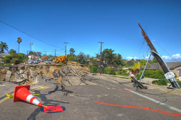
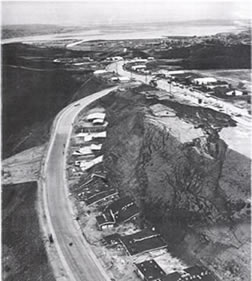
| Thirty years ago (above), the land surface slipped in La Jolla, Calif., in much the same spot as it slipped this year (below). Like in many parts of the country, this can be activated by heavy rains or seismic activity. | |
 Ben Cutshall |
Natural hazards differ from natural disasters in that “disasters” only affect humans. In the past year, humans have clashed with nature around the world: severe droughts in the American South; unprecedented heat waves and wildfires in Southern Europe; severe storms and floods in the American Midwest, Mexico, Northern Europe and much of Southeast Asia; landslides in the Pacific Northwest, California and Southeast Asia; devastating earthquakes in Indonesia; and typhoons in the Pacific, just to name a few. And climate change models predict that the intensity of storms, heat waves, droughts and related phenomena are only going to worsen over the coming decades.
However, an interesting trend is beginning to emerge, says Scott Burns, a geology professor at Portland State University in Oregon: “Man is beginning to work with Mother Nature instead of against her,” he says. Burns spoke with Geotimes managing editor Megan Sever about the new trend, what we’ve learned from 2005’s Hurricane Katrina and why houses just keep sliding down hillsides.
MS: What’s the biggest story this year? And what trends have we seen?
SB: Well, there are a whole bunch of things happening. Number one, probably — not only in the United States but around the world — is the number of geological hazards that have occurred, which are affecting us in engineering geology. We’re talking about landslides, floods, hurricanes (which cause floods), volcanoes, earthquakes and the like.
Katrina was a huge disaster two years ago that really affected us: We’re now looking at the quality of levees everywhere, because what caused most of the destruction in New Orleans was the levees breaking, causing a huge flood and really wreaking havoc. And it was poor quality in the construction of those levees, and not understanding the geology when they were built, that led to the destruction. All over the United States and around the world, that one event led us to say, “We need to check our levees.”
Another trend we’re seeing is that we continue to look at the quality of our dams, asking, “Are they going to hold up?” and figuring out what needs to be done to ensure they are safe. Another big deal is dam removal. This is a huge topic. It takes a vast amount of geology [to properly remove a dam], because you want to get the streams repaired so they can transport the fish. But you have all this sedimentation that has occurred behind the dams, so you have to figure out what to do with that. This is a complex issue.
Another major event that occurred this summer was the bridge that collapsed in Minnesota [in August]. That led immediately to everybody looking at their bridges, wondering if theirs were safe.
MS: The bridge collapse wasn’t geologic though. How are engineering geologists involved in such disasters?
SB: We’re called in to evaluate the characteristics of the river running underneath the bridge and the geology below. The river characteristics and the type of geology, whether bedrock or sediments, and whether there’s an earthquake risk, are going to dictate what type of bridge is built. Design techniques are based around these properties and we make sure they’re safe.
MS: It seems like a lot of what we’re talking about is reparative work or reevaluations.
SB: Yes, our infrastructure in the United States is aging. Our bridges, roads, buildings, dams and levees are all aging. We’re now beginning to go back and say, “Is that infrastructure safe?” And we’re finding out that in some cases, it’s not. We aren’t building a lot of new dams, levees or bridges. And we aren’t building highways like we used to. We’re going back and changing things and redoing things. And when we redo them, we want to make sure that they’re geologically sound.
MS: There have been a number of landslides and debris flows this year, from California to the Pacific Northwest to Southeast Asia. Are such events increasing?
SB: Yes, and we’re going to be seeing more of these. There are landslides and debris flows that occur every year, such as those that occur after forest fires or exceptionally heavy rains. But most big landslides are reactivations of ancient slides. People keep building in these areas, and local agencies keep giving building permits and not requiring geological oversight. For example, in Oregon, the Street of Dreams slide reactivated this year. They built a dozen $3 million houses on this old landslide that started reactivating at the toe. One $3 million house had a big crack down the middle of it within seven months of [the occupants] moving into it. Los Angeles had a whole bunch of landslides this past winter, which occurred after large rainfall events. And most of them are reactivations of old landslides.
MS: So how can we plan for these events or mitigate the human impacts?
SB: First of all, we need people not to build on old landslides. Or, an engineering geologist has to help plan how to mitigate the slide — which can be done, carefully. You just need to take all [potential hazards] into consideration.
Also, cities and states need to work with engineering geologists to update their local ordinances — and that includes most of the hazards, your earthquakes, floods, landslides, etc. We’re trying to get more communities to upgrade their ordinances, and trying to get more geologists involved in that effort.
Another thing we’re trying to do is get more geology departments to teach applied geology. We need to get more young people coming out of departments where they can do applied geology — a field where there are lots of jobs.
The U.S. economy is doing well, so we’ve had this big housing boom and buildings are being put up everywhere. That’s going to lead to a lot of work for engineering geologists.
Links:
“Prevention Is the Best Medicine: Doing Site Evaluations to Prevent Geological Hazard Catastrophes,” Geotimes, February 2007
Engineering Earth, With Kevin Trenberth
After each drought, heat wave or flood, talk abounds over whether the event was caused by global warming or natural variability — and, as a result, over what to do. In the past year, the discussion has focused increasingly on “geoengineering” Earth as a way to stop the effects of climate change — for example, blocking the sun, salting clouds to produce rain on command, or putting carbon dioxide into the ocean.
This fall, Geotimes managing editor Megan Sever spoke with Kevin Trenberth, head of the Climate Analysis Section at the National Center for Atmospheric Research in Boulder, Colo., about the year’s main events and the prospect of geoengineering —a topic he and colleagues examined earlier this year in a paper in Geophysical Research Letters.
MS: It seems like there have been a lot of bad droughts and bad floods this year. Is this year anomalous? Or is it just that we’re now hyper-sensitive to this sort of thing?
KT: It’s hard to say until one gets a bit more information, but my impression is that you’re correct on both counts. The interesting thing this summer is the extraordinary amount of action in the tropics in the Indian Ocean. There has been tremendous amount of convection there that was subsequently reflected in flooding in India and China early in the summer.
In the tropics, there’s usually someplace that is dominant. In 2005, we had an extraordinary hurricane season in the Atlantic with Katrina and Rita and Wilma, and so on. Last year (2006), tropical storm activity was relatively weak in the Atlantic — or actually close to normal. And when there’s an El Niño event, as in 2006, there tends to be more action in the Pacific. And this year, the first part of the season (May to July), the action was much more in the Indian Ocean.
Overall, the hurricane season in the Atlantic has been about normal this year. The only thing that’s been exceptional is that two of the hurricanes were Category-5 storms. And the storms that made landfall in Texas had heavy rains associated with them, which produced tremendous flooding.
And over the summer, severe drought developed in the Southeast and California, with wildfires breaking out in California in October as a result.
It’s very likely that some of this is related to climate change.
MS: You beat me to my next question.
KT: [laughing] I think one of the things we’re learning is that people always ask us, “Is this global warming or is this natural variability?” And in many ways, that’s not really the right question. It’s actually a combination of both, almost inevitably, in every case. The combination of the two means that we are seeing exceptional things happening both in terms of the number and intensity of storms, and especially changes in rainfall and droughts and flooding.
MS: Some scientists have said that they don’t yet have a grasp on hydrologic changes expected with climate change. Are we learning more about that?
KT: I think so, yes. The Intergovernmental Panel on Climate Change report that we put out this year identified some patterns of precipitation changes around the world that are already occurring — general drying in the subtropics and wetter conditions at higher latitudes especially in the Northern Hemisphere. And what’s more, we can simulate those changes in climate models.
Perhaps the bigger change is that more of the precipitation is occurring in heavy rainfall events. What’s happening is that the rising temperatures lead to increased evaporation, which puts more moisture in the atmosphere. And the fact that the atmosphere itself is warming up as well means that it can hold more water vapor. Basically, for every 1 degree Fahrenheit increase in the temperature, the atmosphere can hold about 4 percent more water vapor.
MS: Generally speaking, are extreme events expected to worsen with climate change?
KT: The main changes we expect in extremes are that ironically you get both drought and heavier rains in association with changes in precipitation. In dry places where it is not raining, a drought can set in and the plants wilt a little quicker. The surface moisture evaporates and water vapor gets carried to where there are storms. And because there’s more water vapor in the atmosphere, you get heavier rainfall. Now of course the floods and droughts occur in different places at different times, but those can easily swap from one year to the next. One year you can have flooding and the next year drought.
This means that managing water resources is going to be more of a challenge. There are times when you don’t have enough water, and then there are times when you’ve got too much.
MS: What do you think is bringing geoengineering to the forefront?
KT: Climate change is a difficult problem. I think one reason geoengineering is a popular idea right now is that there’s a certain amount of despair that policymakers won’t be able to work together to solve the problem and therefore climate change is coming, ready or not … So we’re asking, “What can we do to maybe stop it in other ways, by using geoengineering?”
MS: In your GRL paper, you studied the effects of Mount Pinatubo on the global hydrological cycle to see what the effects might be if we simulated a volcanic eruption, as a geoengineering ploy, to block out the sun to cool the planet. What did you find?
KT: We looked at all of the precipitation over land, and all of the river runoff and discharge into the ocean from 1948 onward, and we found that the year following Pinatubo broke all kinds of records. Rainfall and river discharge were by far the lowest of all years since 1948.
So people have been saying, “Maybe we can block out the sun in some fashion and cut down on warming.” This is not exactly the same as stopping the increases in the greenhouse effect, because increases in carbon dioxide in the atmosphere change the outgoing radiation on the planet, whereas if you block out the sun, by emulating a volcano or putting reflectors somewhere between the sun and Earth, then that cuts down the incoming solar radiation.
MS: Generally, do you think geoengineering is a good or bad idea?
KT: It may have its place. But I’m inclined to think of it as a bit like the patient with a broken arm who goes to the doctor and the doctor says, “Take two aspirin and it’ll kill the pain.” But it won’t heal it.
But the other part of geoengineering is that once you start doing it, if you decide that it’s too expensive or that you can’t keep doing it, the downside of suddenly going back to the greenhouse world could be a lot worse than if you’d gradually let warming occur in the first place. I really think there’s a lot more we can do to address the real problem, in cutting back our emissions and cutting back our energy use before we really set on that path.
Links:
“Controlling Nature,” Geotimes, August 2006
"Change in Climate: Q&A with Margaret Leinen," Geotimes, December 2007

