|
 |
features
 |
SAR:
A Versatile New Tool for Earth Science
Geoscientists are depending more and more on synthetic aperture radar's
all-weather, day and night capability — using it to map digital
topography, to study Earth as it moves and to detect and monitor floods,
oil spills or storm damage as quickly as possible.
Rosalind T. Helz et al.
|
|
|
LIDAR:
Mapping a Shoreline by Laser Light
The days of collecting beach profile data solely in the field are gone.
Now coastal geologists are looking to the skies, using a new radar tool
to study changes to the shoreline over large areas.
James C. Gibeaut
|
Precision
Agriculture: Changing the Face of Farming
Commercial farms around the world are changing, and remote sensing is
beginning to play a large role. A new suite of technologies promises to
help farmers better manage their crops at the scale of individual fields.
Doug Rickman et al. |
|
news.html

November 26
Energy bill locked in Senate
November 21
Mercury transitions in the Everglades
November 14
Meeting updates: Particles on Mars and Earth
November 11
Evolution to stay in Texas texts
November 7
Remote mapping
in disaster zones
Webextras
Archive
 Taking
a trip?
Check out Travels in Geology to find geologically significant places to
visit. Taking
a trip?
Check out Travels in Geology to find geologically significant places to
visit. |
 News
Notes News
Notes
Tracing the Navajo sandstone
Tertiary is toast
Government peer review
Stuck between a rock and a cold place
Biosphere 2 bubble burst
Biblical tunnel timing
Turkish tectonics
Geophenomena
New
pursuit of near-Earth asteroids
Finding faults in Washington
|
 |
 |
|
views.html
Comment
Civilian Agencies Implement
the Bush Space Policy
In April, President Bush authorized a national policy establishing guidance
for federal use of commercial satellite data. Civilian agencies must now examine
their needs.
Ralph J. Thompson
Political Scene
Our Public Lands
Managing public access and wilderness protection on federal lands is one of
the most enduring policy-making challenges.
Larry Kennedy
Geologic Column
The Romance of Geology in
Russia
In the 1960s, the Soviet Union was a vast expanse waiting to be explored. It
was geologists who took the call, traveling to the farthest reaches of the country
— inspiring a new generation of geological explorers.
Paul Belasky
|
departments
Profiles
Ed
Roy: Thinking and Teaching in Texas
Energy & Resources
Alaska's
latest development stir
Mineral
Resource of the Month: Silicon
 Check out this month's
Energy Notes!
Check out this month's
Energy Notes!
Geomedia
Fossils
of the Florissant
Areal
mapping applications
On
the Web
|
 |
 |
cover
 ON
THE COVER ON
THE COVER
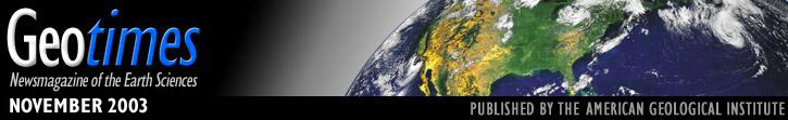
This shaded-relief and color-coded topographic
image shows a portion of Matagorda Island, Texas, off the coast of the Gulf of
Mexico. Elevation data were acquired by the University of Texas at Austin with
an airborne laser system, called LIDAR (light detection and ranging). Coastal
geologists are beginning to use this system to map historical shoreline change.
Read the story on tracking shoreline change.
Image courtesy of James Gibeaut.
|
announcing
Coming Soon...
December:
Global Mining and Sustainability
Visit our
searchable archive.

|