
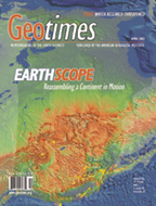
 EarthScope:
Reassembling a Continent in Motion
|
| Science
on Tribal Lands
Land management requires good earth science, especially for one of the country's most significant land-owning populations: Native Americans. Susan M. Marcus |
Coming
Soon...
May:
Water
June: Preserving
Geoscience Data
July: Highlights
of trends and research
Announcing
STUDENTS:
Read our special careers
page.
Do you love science
and writing?
Apply now for
the Geotimes Fall 2002 internship
April 19
Superplumes across the mantle
April 16
Deadlines approaching for Wash. and N.H. geologists
April 12
Marshlands in danger
April 1
Aftershocks in Taiwan
March 29
Piece of the tectonic puzzle found
March 26
Shallow earthquake hits Afghanistan
News
Notes
 USGS
water research threatened
USGS
water research threatened
Life
on the rocks
East
vs. West in the inner core
Trouble
in British Columbia
Field
Notes
Comment
Science Funding out of
Balance
Advances
in science and technology are keystones of economic prosperity. We need to support
a broad portfolio.
The Honorable Sherwood Boehlert
Political Scene
Turning a Request
into Reality
It is going to take a major effort by the geoscience community
to convince Congress to fund EarthScope. But the long-term payoff will be worth
it.
David Applegate
Geophenomena
 Slip
and slide in Kentucky
Slip
and slide in Kentucky
Dry
spell in the Eastern U.S.
Quake
shows Turkey quick and nimble
Webextras
on recent large quakes
Technology
3-2-1
Meltdown
The Cryobot: It burrows, it melts, it collects.
Christina Reed
 ON
THE COVER
ON
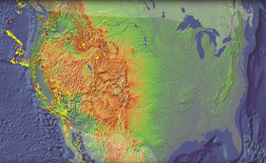
THE COVER The continental United States (pictured here rotated 90 degrees) is home to active faults and volcanoes. In this image, yellow dots indicate earthquakes with magnitudes of less than 6.0 that have occurred since 1980. Open circles are earthquakes between magnitudes of 6.4 and 8.0 that have hit since 1900. Triangles represent major volcanoes, white lines represent active faults, and the red circle and triangle in the center mark the Yellowstone hot spot. Earth scientists still have many questions about the structure of the North American continent and how all these dynamic processes relate to each other. Read story. Photo supplied courtesy of the IRIS Consortium.
 Print
Table of Contents
Print
Table of Contents From the Editor
Where on Earth?
Society Page
Geomedia
Calendar
Classifieds
